| NWS Tallahassee Significant Weather Events |
 |
 |
 |
| Event Type | Event Date(s) |
Event Description (click links below for event details) |
| Tornado | January 8-9, 2024 |
January Tornado Outbreak at the Start of 2024. A powerful storm system moved across the southeast portions of the United States January 8 and 9th, 2024. The system brought widespread damaging winds overnight and into the morning hours of January 9th. Additionally, a powerful squall line traversed the area bringing another round of damaging winds and several tornadoes during the morning of January 9th. Information is preliminary but several injuries and one fatality occurred as a result of the tornado outbreak. |
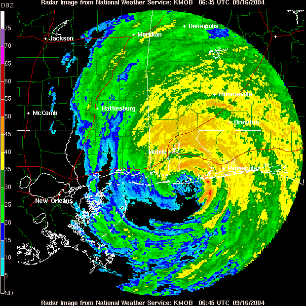
| Hurricane | August 30, 2023 |
Hurricane Idalia makes Landfall in the Southeast Big Bend of Florida Hurricane Idalia makes landfall across the southeast Big Bend of Florida. It produced one of the largest storm surges observed for many residents of coastal Taylor/Dixie county and it rivaled/exceeded observations from the 1993 Superstorm in several locations. Idalia also brought extensive wind damage from the coast inland to north Florida and south central Georgia. |
| Tornado |
Late December 2021 to Early January 2022 |
Tornadoes Close Out 2021 and Begin 2022. The weather brought an active end to 2021 and a active start to 2022 across the area. Through the end of 2021, and into 2022, there were several days of thunderstorm activity across the forecast area. A few of these storms did end up producing tornadoes. Through the period of December 29 into January 2nd, 4 tornadoes occurred across the forecast area. |
| Tropical Storm | September 8, 2021 |
Tropical Storm Mindy develops along the northern Gulf Coast. Tropical Storm Mindy was a tropical cyclone that quickly developed along the northern Gulf coast of Florida. Thankfully, the short time to development limited the overall impacts across the area. However, strong wind gusts along the coast, and inland, did cause downed trees and some power outages. Very heavy rainfall near the center of the storm also caused areas of flash flooding. |
| Tropical Storm | August 16, 2021 |
Tropical Storm Fred Makes Landfall along the Forgotten Coast. Tropical Storm Fred, at its strongest, was a tropical storm containing sustained winds up to 65mph and a central pressure of 994mb. The main impacts to our region revolved around heavy rainfall, strong wind gusts along our coastal communities, and storm surge ranging from 1 to 4 feet along the coast of the FL Panhandle and Big Bend (highest across the Big Bend at Indian Pass and locations eastward). |
| Tropical Storm | July 7, 2021 |
Tropical Storm Elsa impacts SE Big Bend & SW GA Tropical Storm Elsa made landfall along Taylor/Dixie County, FL on July 7th, bringing flooding and strong winds to the southeast Big Bend and portions of southwest Georgia. |
|
Tornado Severe Weather |
April 24, 2021 |
April 24th Severe Weather Outbreak April 24th was the biggest severe event in our forecast area this season, when a total of 60 convective warnings were issued, which led to 5 confirmed tornadoes, widespread wind damage, multiple hail reports, and flash flooding. The combined impacts during the prolonged period resulted in 139 storm reports, a local record for a single day! |
| Tornado | April 10, 2021 |
Several Tornadoes Impact the Florida Panhandle In the morning hours of April 10, 2021 a large squall line quickly progressed through the Tallahassee forecast area. Widespread damaging wind gusts were observed with the passage of this system. There were also a few recorded tornadoes that were embedded within the squall line. In all, 4 tornadoes were confirmed by NWS officials, all across the Florida Panhandle. There were also many reports of wind damage as 60-70 mph winds in the squall line moved through. |
| Tornado | March 18, 2021 |
5 Tornadoes impact portions of Florida, Alabama, and Georgia. In the early morning hours of Thursday, March 18th a line of severe thunderstorms moved across the area ahead of a cold front, producing several tornadoes across Southeast Alabama, the Florida Panhandle, and Southwest Georgia. Overall, at least 6 tornadoes were confirmed through NWS survey work. Four of the tornadoes have been rated EF-1, with two additional tornadoes rated EF-0. |
| Tornado | February 15, 2021 |
A line of storms produces 3 tornadoes, including an EF-2 over Damascus, GA A line of storms moved through region on the afternoon of February 15, 2021. Several tornado warnings were issued, along with many severe thunderstorm warnings. The main feature that made this event significant was a single storm that traveled onshore in Bay County, FL. The storm persisted for over 2 hours as it traveled quickly northeast into southwestern Georgia. Along its path, several severe thunderstorm warnings were issued along with at least 5 tornado warnings. In total, there were 3 confirmed tornadoes from this storm, with the strongest being an EF-2 that impacted Damascus, GA. |
| Tornado | January 27, 2021 |
Tornado Strikes the Tallahassee Airport, and other portions of Leon County A cold front moved through the tri-state region on the morning of Wednesday January 27, 2021. While this severe weather event was on the lower end of the spectrum for severity, it was strong enough to produce several tornado-warned storms. In total, 5 tornado warnings and 8 severe-thunderstorm warnings were issued for this event. Thankfully there were no injuries directly related to the tornado, but there was sporadic damage at the airport and across southern portions of the county. |
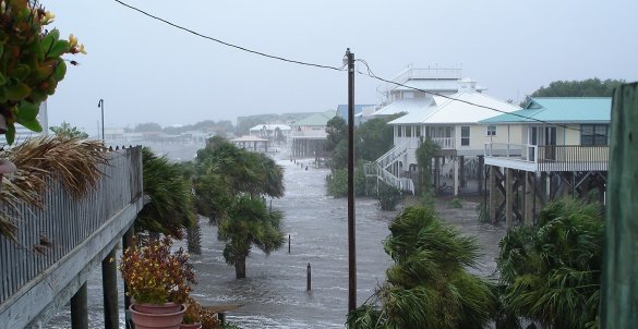
| Hurricane | September 14 - 16, 2020 |
Hurricane Sally Makes Landfall Just West of the Region Hurricane Sally made landfall early on the morning of September 16 across Gulf Shores Alabama. While the greatest impacts for Hurricane Sally struck outside our forecast area, in portions of the western Florida Panhandle and southern Alabama, we were not spared from Sally's damage. The greatest impacts to our forecast area came in the form of very heavy rain, flooding on and away from area rivers, and many tornado warnings. |
| Tropical Storm | June 5-7, 2020 |
Tropical Storm Cristobal Impacts on the Tri-State region Tropical Storm Cristobal started as an area of circulation over the Yucatan peninsula which was the remnants of Tropical Storm Amanda that moved east over Mexico from the eastern Pacific Ocean. It reformed as a Tropical Depression over the Bay of Campeche on June 1st, before strengthening to a tropical storm and moving south to make landfall in Mexico on June 3rd, with 60 MPH sustained winds. It meandered over land as a Tropical Depression for over 48 hours before restrengthening to a Tropical Storm and moving back over the southern Gulf of Mexico on June 5. Cristobal tracked northward across the Gulf of Mexico and eventually made landfall in southeast Louisiana on Sunday, June 7, 2020 at 5 PM CDT with winds of 50 MPH and a pressure of 992 mb. Because of the size of the system, impacts were felt well to the east of the center, with heavy rain, flash flooding and storm surge flooding observed across the forecast area. A full summary of the observed hazards and impacts across the National Weather Service Tallahassee forecast office can be found in the Post-Tropical Cyclone Report |
|
Tornado Severe Weather |
April 19 - 29, 2020 |
Severe Weather Brings Busy End to April. 4/19-4/29, 2020 A busy April continued as we entered the second half of the month. An overnight severe weather event moved into the area on 19th/20th and brought with it 7 tornadoes to the region as a strong squall line progressed through the area. These tornadoes occurred in portions of Alabama and Georgia and sadly caused one death in Alabama. The line of storms continued east overnight and spawned another tornado in portions of Mitchell and Worth counties early in the morning. As this event pushed through, another event was developing in its wake and would move through on April 23rd. This event brought two distinct rounds of severe weather to the area. The first round brought widespread damaging winds across Alabama, Georgia, and portions of the FL Panhandle. One storm spawned three tornadoes as it progressed east in the morning/early afternoon across south-central Georgia. As the main front moved through, another round of severe weather developed. This round was the most active of the two, and multiple tornadoes developed across the Panhandle and the Big Bend as it moved east. Overall, the April 23rd event brought 11 tornadoes and one very strong microburst as a supercell tracked across the area. Lastly, a more isolated round of severe weather developed on the evening of the 29th as a line of storms moved through the tri-state region with an EF-1 tornado moving across portions of Gadsden county. |
|
Tornado Severe Weather |
April 13, 2020 |
Severe Weather and Tornado Event A surface low developed on Sunday, moving across the middle Mississippi Valley with a cold front stretching across the Lower Mississippi Valley. By Sunday night, the upper level wave and the surface low lifted into the Tennessee and Ohio Valleys, with the surface front strengthening and pushing into the southeast. While a few storms developed ahead of a main line of storms, the severe storms were confined to a line of storms that moved into southeast Alabama Sunday night, pushed through the remainder of the forecast area and weakened in the far southeast portion of the Big Bend. This front stalled across the southeast Big Bend and brought a few days of perturbed weather to the forecast area. |
|
Tornado Severe Weather |
April 8, 2020 |
April 8th Tornado and other Severe Weather West and northwest flow overhead a moist airmass on Wednesday, April 8th, brought widespread showers and thunderstorms to the southeast. Several of these became severe across the region. The strongest storms brought sporadic wind damage and some hail to the region. One storm also brought a likely tornado just north of Valdosta, GA and in Lanier and Berrien counties. Tornado survey is planned after coordination with local officials. |
| Tornado | March 31, 2020 |
5 Tornadoes Impact the Tri-State region. A busy day of weather on Tuesday, March 31, 2020 brought widespread severe weather to the area with five tornadoes confirmed across the region. The strongest of these tornadoes was an EF-2 (when it was in Alabama) that started in Barbour county before it moved northeast into Quitman county Georgia and was rated an EF-1. Other tornadoes impacted parts of the Florida Panhandle, including one that crossed Interstate 10 in Madison county Florida and shutdown the interstate for several hours. |
| Tornado | December 17, 2019 |
Multiple Tornadoes Impact Georgia/Alabama During the late morning and afternoon of December 17th, 2019, multiple tornadoes impacted counties in Georgia and Alabama. The strongest of these tornadoes was an EF-2 that struck portions of Irwin and Ben Hill counties near Fitzgerald and Mystic in southern Georgia. The storm that spawned this strong EF-2 tornado had previously generated 3 tornadoes in locations spanning from SE Alabama into Mystic Georgia. The animated image below begins just before it spawned the first tornado in Houston county in Alabama. |
| Tropical Storm | October 17-19, 2019 |
Tropical Storm Nestor Makes Landfall in the FL Panhandle Tropical Storm Nestor, at its strongest, was a tropical storm containing sustained winds up to 60 mph and a central pressure of 996mb. The main impacts to our region revolved mostly around strong winds along our coastal locations, and storm surge ranging from 1 to 3 feet along the coast of the FL Panhandle and Big Bend. While impacts outside of surge were mostly limited across our region, heavy rain and tornadoes did cause more damage across the Peninsula of FL. For more information on the impacts from Nestor's tornadoes, please see the write up of this event from the National Weather Service in Tampa. |
| Flooding Rain | August 16-25, 2019 |
Steinhatchee River Heavy Rain (Rainfall Total Estimates) On August 16th, a trough of low pressure associated with a frontal boundary to the north, stalled in the northeast Gulf coast for a few days. This system brought copious amounts of rainfall to the southeast Big Bend area, which led to significant localized flooding. In Steinhatchee, FL (Taylor County), a whopping 28” of rain fell in 3 days (16” on August 17th), with some other measurements showing 31-39” (around half of the annual average accumulation!). The river remained above flood stage through August 25th, with an observed height of 22 ft on August 19th. Several flood watches and warnings were issued for other counties in our area during this event as well. |
| Tornado | April 14, 2019 |
EF-1 Tornado Impacts Colquitt County near Moultrie, GA A squall line moved through the forecast area on April 14, 2019. The main severe impacts were damaging winds, but there was a tornado recorded during this event. |
| Svr Wx / Hail | March 26, 2019 |
Copious Amounts of Hail Fall Across Georgia/Northern Florida A storm system moving through the area, combined with anomalously cold upper level temperatures yielded storms that produced copious amounts of hail across the forecast area. The scene was almost winter-like in some places and led to dangerous driving conditions across some are roads. |
| Tornado Outbreak | March 3, 2019 |
March 3, 2019 Tornado Outbreak During this severe weather event, 12 tornadoes were confirmed through field surveys within the NWS Tallahassee area of responsibility. The strongest tornado was rated EF-3 in Leon/Jefferson County, Florida. This was only the second F3 or EF-3 to affect Leon County since 1945. The National Weather Service in Tallahassee would like to extend our appreciation to the many emergency management, law enforcement, and fire rescue personnel that assisted in these field surveys over the last three days. |
| Tornado | January 19, 2019 |
Tornado Impacts Tyndall Air Force Base A brief EF-1 tornado with winds around 90 mph touched down on Tyndall Air Force Base. The tornado moved a car, broke car windows, tore a portion of a new roof off of barracks and flipped dumpsters and garbage cans on their sides.. |
| Tornado | January 4, 2019 |
Tornadoes Strike Henry County (AL) and Clay County (GA) An EF-0 tornado struck Henry County, AL with an EF-1 tornado tracking just under a quarter of a mile across Clay County, GA early on the morning of January 4, 2019. |
| Tornado/Flooding | December 1-3, 2018 |
Widespread Flooding and Multiple Tornadoes Impact the Tri-State Area A multi-day heavy rain event led to both flash flooding and river flooding across the tri-state area. In addition, four tornadoes occurred across southeast Alabama, southwest Georgia and the Florida Big Bend. |
| Hurricane | October 10, 2018 |
Hurricane Michael Strikes the Florida Panhandle Catastrophic Hurricane Michael made landfall in the Florida Panhandle in the afternoon of Wednesday, October 10. The storm brought widespread surge and wind damage to the coast with the wind damage extending well inland into southwest Georgia. |
| Tropical Storm | May 28, 2018 |
Subtropical Storm Alberto was one of the earliest subtropical or tropical systems to develop and move into the Gulf of Mexico in recorded history. Alberto is the fourth May storm to make landfall along the Florida Gulf Coast since 1953, and the first May land-falling tropical cyclone in the state of Florida since Tropical Storm Beryl in 2012. Subtropical Storm Alberto made landfall near Laguna Beach, Florida, approximately 15 miles west of Panama City, FL, on Monday, May 28 with winds near 45 mph. Overall impacts were minor with 1.5-3 feet of storm surge inundation along the Florida Big Bend coast. |
| Svr Wx / Tornado | April 22, 2018 |
Widespread showers and thunderstorms moved through the tri-state area. While rotation was noted in multiple storms, one of the storms produced a short lived, EF-0 tornado that tracked across Fort Rucker in Alabama. |
| Svr Wx / Tornado | April 15, 2018 |
Two Tornadoes Hit Florida Panhandle and Southwest Georgia Showers and thunderstorms moved through the tri-state area with a line of organized storms bringing damaging winds to the Florida Panhandle and Southwest Georgia. In addition, a cell behind the main line of storms, embedded within stratiform rain, produced a tornado in Bay County, FL and later produced another tornado in Decatur County, GA. |
| Winter Weather | January 17, 2018 |
Snow and Sleet Across the Tri-State Area Snow and sleet fell across the tri-state area bringing a half to one inch of snow and sleet to the area. While accumulation did occur, impacts were mainly limited to elevated surfaces. |
| Winter Weather | January 3, 2018 |
Snow and Ice Fall Across the FL Big Bend and southern Georgia Snow and ice fell across the Florida Big Bend and southern Georgia on January 3, 2018. Around one to two inches of snow fell across southwest Georgia near Valdosta with 0.25 inches or less of ice falling across the Big Bend. Higher amounts of both snow and ice fell east of the area (southeast Georgia and northeast Florida). Ice accumulation was enough to result in power outages across the Suwannee River Valley. |
| Hurricane | October 7, 2017 |
Hurricane Nate made landfall along the central Gulf coast on Saturday, October 7, 2017 and brought heavy rain and gusty winds to the Florida Panhandle and southeast Alabama. In addition, coastal flooding was observed. |
| Hurricane | September 11, 2017 |
Hurricane Irma tracked across the Florida Peninsula and then across the Big Bend and southwest Georgia with effects across the area felt on Monday, September 11, 2017. The tropical cyclone downed widespread trees and power lines, particularly across the Big Bend and southwest Georgia, and caused numerous power outages. |
| Svr Wx / Tornado | January 21-22, 2017 |
Multi Day Severe Weather Event A multi-day severe weather event struck the southeast January 21-22, 2017 with three rounds of severe weather moving through the area. The first round of severe weather started during the mid-morning hours on Saturday, January 21, 2017 as a squall line pushed into southeast Alabama and the Florida panhandle. As it pushed eastward nine warnings were issued with a total of 18 damaging wind reports (trees and power lines downed) related to these storms. |
| Svr Wx / Tornado | January 2, 2017 |
Tornadoes and Damaging Wind Event A strong line of showers and thunderstorms moved through southeast Alabama, southwest Georgia and north Florida on Monday, January 2, 2017. More than 30 warnings were issued across the tri-state area as these powerful storms moved through. Ten tornadoes were confirmed across southeast Alabama and southwest Georgia with additional wind damage noted in Geneva County, AL and Dougherty and Turner Counties in Georgia. |
| Hurricane | September 1-2, 2016 |
Hurricane Hermine slammed into the Big Bend early September 1st making landfall around 1:30AM EDT just east of St. Mark's, Florida near the Wakulla-Jefferson County line. Maximum sustained winds were near 80 mph with a central pressure of 982mb. Hermine brought devastating winds to the Big Bend area which resulted in extensive downed trees and powerlines causing significant power outages lasting days. |
| Svr Wx / Tornado | December 29, 2014 |
Valdosta Tornado of December 29, 2014 A tornado touched down in Valdosta, Georgia. Several buildings were damaged at the Langdale Forest Product Company. A survey team determined that the tornado was rated EF2 on the Enhanced Fujita Scale and maximum winds were around 120 mph. |
| Svr Wx / Flooding | December 23rd-24th 2014 |
Pre-Christmas Flooding and Wind Damage This gallery includes images of flooding and thunderstorm wind damage that occurred across the NWS Tallahassee County Warning Area on December 23-24, 2014. If you have any additional photos you would like to submit for this page, please send them to our webmaster. Click on each image for a larger view. |
| Svr Wx / Tornado | November 17th 2014 |
Severe weather, including a few tornadoes, impacted the forecast area. Most of the severe weather occurred in the Florida Panhandle and Southwest GA. There were three confirmed tornadoes. One of those was a long-track tornado that reached EF2 intensity near Blountstown, FL and stayed on the ground longer than any tornado in Florida since February 2007. It was also only the third significant tornado to occur in the local forecast area since March 2007. |
| Svr Wx / Tornado | May 10th 2014 |
Several small supercells formed in far southeastern Alabama on the afternoon of May 10. The leading cell in the group generated a tornado in southeastern Geneva County. A National Weather Service Survey Team found that an EF1 tornado touched down just north of the Florida State line along County Road 9. |
| Svr Wx / Tornado / Flooding | April 29-30th 2014 |
Jackson County Tornadoes and FL Panhandle Flash Flooding Severe weather and flooding impacted the forecast area once again on April 29-30, 2014. Two EF1 tornadoes were confirmed in Jackson County, FL and excessive rainfall caused flash flooding and river flooding across the region. |
| Svr Wx / Tornado / Flooding | April 7th 2014 |
Irwin and Leon County Tornadoes with Georgia Flooding Severe weather impacted the forecast area on April 7, 2014, and was accompanied by some flooding. Most of the severe wind gusts occurred along the coast. There were also two tornadoes confirmed in the forecast area, and EF1 in Irwin County, GA and an EF0 in Leon County, FL. Much of the forecast area received in excess of three inches of rain with most areal flooding concentrated in Dougherty and Worth Counties in GA. |
| Winter Weather | January 28th-29th 2014 |
A very rare ice storm occurred across much of the forecast area with ice being reported all the way to the Gulf Coast! The event resulted in the closing of area schools as well as many bridges and overpasses and even a long stretch of Interstate 10. |
| Flooding | July 2nd-6th 2013 |
Widespread Riverine, Areal and Flash Flooding A very anomalous pattern set up across the U.S. in early July featuring a persistent upper level trough over and just west of the Mississippi Valley and a downstream ridge off the Mid Atlantic Coast. This brought deep layer moist tropical air into the Southeast for several consecutive days resulting in torrential rains, flash flooding and river flooding. |
| Tropical Storm | June 6th 2013 |
Tropical Storm Andrea was the first tropical cyclone of the 2013 Atlantic hurricane season. The storm developed in the east-central Gulf of Mexico during the late afternoon hours of June 5th and made landfall about 24 hours later in Dixie County, about 10 miles down the coast from Steinhatchee, FL. Impacts on the local forecast area were generally minimal. |
| Svr Wx | March 23rd-24th 2013 |
Numerous Hail Storms with Some Wind Damage Two episodes of severe weather occurred over the weekend of March 23rd and 24th, 2013. On Saturday morning March 23rd, several storms produced large hail across the Florida Panhandle & Big Bend as well as adjacent areas of Southwest & South Central Georgia. A second brief severe weather event the following morning downed trees across parts of Leon County, FL and adjacent areas in GA. |
| Flooding | February 22nd-26th 2013 |
Widespread Riverine, Areal and Flash Flooding A very active pattern set up across the Gulf Coast states during the last week of February 2013. Several energetic impulses swept overhead in persistent southwesterly flow aloft as a frontal boundary focused bands of heavy rain across the region. While several espisodes of severe weather occurred during this period, the heavy rain and accompanying flooding were the primary impacts. |
| Tropical Storm | June 25-26th 2012 |
Debby was the first tropical cyclone to bring tropical storm conditions to the NWS Tallahassee County Warning area since Ida in November 2009. Debby was the earliest 4th storm of the season to develop since records began in the middle of the 19th century. Debby was a very difficult storm to forecast, but ultimately brought torrential rainfall to the Florida Big Bend. This resulted in record rainfall in Wakulla County, record flooding on the Sopchoppy River, and a record discharge from Wakulla Springs. |
| Svr Wx / Tornado | March 3rd 2012 |
Severe Thunderstorms & a Tornado Severe weather struck north Florida and south Georgia on Saturday, March 3rd and resulted in an EF-3 tornado that tracked across Lowndes and Lanier counties. The tornado downed trees, damaged houses, destroyed a shed and clipped a camper during it's almost 11 mile track. Winds in the tornado peaked at 140 mph. Other damage was also noted across the CWA from stright-line winds. |
| Svr Wx / Tornado | February 24th 2012 |
Severe Thunderstorms & a Tornado Severe weather and flooding occurred across the Southeast U.S. on 24 February 2012 including portions of the NWS Tallahassee County Warning Area (CWA). This was just over five days after another severe weather event had impacted the region. The vast majority of the reports were straight line wind damage, but there was one tornado confirmed. WFO Tallahassee issued a total of 15 convective warnings during the event (12 severe and 3 tornado) and a special marine warning. Of the 15 warnings, 10 were verified. The average lead time was 16-17 minutes. |
| Svr Wx / Flooding | February 18-19th 2012 |
Severe Thunderstorms & Flooding Severe weather and flooding occurred along the Gulf Coast on 18-19 February 2012 including northern and western portions of the NWS Tallahassee County Warning Area (CWA). The vast majority of the reports were straight line wind damage. WFO Tallahassee issued a total of 17 convective warnings during the event along with several flood warnings/advisories and a couple of special marine warnings. Of the 17 warnings, 13 were verified and there were no unwarned events. The average lead time for the convective warnings was 19-20 minutes.Wdiespread 2-3 inch rainfall with isolated 5-inch amounts did cause some nuisance flooding, although there was no riverine flooding. |
| Svr Wx / Tornado | September 5th 2011 |
Severe Weather - Post-tropical Cyclone Lee A widespread outbreak of severe thunderstorms occurred on Labor Day across much of the NWS Tallahassee County Warning Area (CWA). This event was forced by unseasonably strong wind fields associated with a potent extra-tropical cyclone that was formerly Tropical Storm Lee. WFO Tallahassee issued a total of 35 convective warnings during the event along with several special marine warnings. Of those 35 warnings, 28 were verified. A total of 52 reports were received and 49 of those were warned for. Satistically, this resulted in a POD of 0.94, FAR of just 0.20 and a CSI a very impressive 0.76. |
| Svr Wx / Tornado | April 5th 2011 |
A potent squall line of severe thunderstorms raced eastward across the entire southeastern U.S. from the morning of April 4 through the afternoon of April 5, 2011. In a matter of just 30 hours, this squall line brought widespread damaging winds to the Ozarks, Tennessee and Ohio Valleys, all of the Gulf Coast states including Florida, and the Carolinas and Mid Atlantic States. This system was one of the most prolific severe weather producers to ever impact the nation. Locally, the system swept across the WFO Tallahassee forecast area from Coffee County AL to Dixie County FL in just over 6 hours. The office received 65 individual reports of severe weather from 40 of the 48 counties in our service area. |
| Svr Wx / Tornado | March 26-27th 2011 |
Two outbreaks of large hail-producing super cell thunderstorms occurred over the weekend of March 26-27, 2011. The number of super cells, structure of the storms, and number of reports of large hail received over this two-day event is unprecedented in this forecast area and reminiscent of events that occur out in the plains. |
| Winter Weather | January 10th 2011 |
A very rare ice storm occurred across the northern portions of the NWS Tallahassee forecast area. The ice mainly accumulated on trees, power lines and cars. Isolated reports of icy roads were also received, mainly bridges and overpasses. A few locations saw sufficient ice accumulation to bring down power lines. |
| Svr Wx / Tornado | April 8th 2010 |
Numerous thunderstorms resulted in isolated tornadoes and wind damage during the afternoon and evening of April 8th, 2010. Tornadoes were confirmed in Coffee County, AL, and Gadsden County , FL. Straight-line wind damage was seen in portions of southwest Georgia, along with Jefferson and Madison Counties in Florida. |
| Winter Weather | February 12th 2010 |
A rare accumulating snow occurred across the northern half of the Tallahassee County Warning Area. Some areas saw heavy snow accumulations in excess of 4 inches. Accumulating snow occurred as far south as the Florida Panhandle and the southern tier counties in south Georgia. After this storm pulled away, 49 of the 50 states had snow on the ground at the same time, Hawaii being the only exception. |
| Tropical Storm | November 9-11th 2009 |
Ida, which developed in the western Caribbean on November 4th, intensified to a tropical storm on November 4th, and to a Category 2 hurricane on November 8th. Ida moved north-northwest across the central Gulf of Mexico, and came ashore near Mobile Bay as a tropical storm on November 10th. Ida produced a swath of heavy rainfall from the western Florida Panhandle across northern and central Alabama, Georgia, and through the Carolinas. Ida was one of the latest-season tropical cyclones to impact the forecast area. It was the 2nd latest hurricane to develop in the Gulf and eventually make landfall along the northern Gulf Coast. Of course many around here remember the record-holder, Hurricane Kate, which made landfall near Mexico Beach on November 21, 1985. |
| Tropical Storm | August 16-17th 2009 |
It seemed like Claudette came out of nowhere. When folks went to bed Saturday Night, there was a tropical wave in the eastern Gulf of Mexico. By the time they awoke on the morning of Sunday August 16th, Tropical Depression 4 had formed and there were tropical storm warnings in effect along the Gulf coast. By midday, the system had strengthened into Tropical Storm Claudette and landfall occurred that night in the Florida Panhandle near Fort Walton Beach. |
| Svr Wx / Tornado | July 2nd 2009 |
A relatively brief period of significant severe weather occurred during the hours of peak heating on the afternoon of Thursday, July 2, 2009. Numerous reports of hail and damaging winds were received during a 4-hr period that afternoon, with the bulk of the reports coming during a 2.5-hr stretch from 3:30 to 6:00 PM EDT. Most of the severe weather occurred in Florida and extreme southern Georgia with a particularly severe storm racing across Tallahassee, FL during rush hour. |
| Svr Wx / Tornado | April 13th 2009 |
On Monday, April 13, 2009, a series of bowing segments of severe storms produced numerous instances of straight-line wind damage and large hail across the entire forecast area including Southeast Alabama, Southwest & South Central Georgia, and the Florida Panhandle and Big Bend. An EF-1 tornado went through Fitzgerald, GA, and there was also a tornado reported in Slocomb in Geneva County, AL. Many of the storms that occurred on this day resulted in flooding of low lying poor drainage areas, including some urban areas in Panama City and Tallahassee, FL. Storm total rainfall generally ranged from 2.5-3.5 inches across the forecast area and this unfortunately reversed the trend of falling stages at many area rivers that saw significant flooding from extremely heavy rains that fell earlier in the month. In many cases, rivers are predicted to exceed flood stage once again. |
| Svr Wx / Tornado | March 26-28th 2009 April 2nd 2009 April 5th 2009 |
Multi-Day Severe Weather/Record Flooding A very active weather pattern set up across the U.S. in late March 2009 and continued through the first week of April. During an 11-day stretch, the NWS Tallahassee forecast area experienced six separate severe weather episodes. In addition to the severe weather, excessive rainfall produced widespread areal flooding with many areas receiving in excess of a foot of rain during this period. This eventually translated into a major riverine flooding event, with the Withlacoochee River establishing a new flood of record and the Suwannee predicted to follow suit. If the predicted levels on the Suwannee River are realized, major roads such as U.S. 90 and Interstate 10 may be closed near the river. |
| Svr Wx / Tornado | February 28th 2009 |
On Saturday, February 28, 2009, a vigorous upper-air disturbance was approaching the southeast U.S. from the northwest. An east-west surface frontal boundary had been stationary for several days across central GA and AL. A surface low developed on the frontal boundary in GA, which began to push the front southward into southern AL and the Florida Big Bend on Saturday evening. Out ahead of the cold front, moist, unstable air, coupled with increased vertical wind shear, produced several severe thunderstorms across the Tallahassee County Warning Area. Straight-line wind damage was reported in southeast AL, southwest and south central GA, and the eastern Florida Panhandle, with the most significant damage being reported in Tift County, GA. Golfball-sized hail was also reported in Holmes County, FL, north of Interstate 10 near New Hope. |
| Svr Wx / Tornado | February 18-19th 2009 |
Long-track Supercell with Tornadoes A long-lived supercell thunderstorm developed in southwest Alabama east of Mobile and traversed the Florida Panhandle and much of South Georgia, crossing the entire NWS Tallahassee forecast area. It is estimated that the supercell averaged 60mph as it moved across the region. This storm not only produced baseball-sized hail and 70-80mph wind gusts in Walton and Holmes Counties in the Florida Panhandle, but also spawned an EF-2 tornado that tracked from central Grady County across much of Thomas County, and a short-track EF-3 tornado that touched down near Boston in eastern Thomas County. |
| Svr Wx / Tornado | October 8th 2008 |
Several lines of strong to severe thunderstorms formed ahead of the cold front and strong low pressure system over southern Alabama and the Florida Panhandle during the morning, then moved into portions of southeast Alabama, southwest Georgia, and the Florida Big Bend in the afternoon. There were eight confirmed tornadoes, six EF0 and two EF1, as well as a few reports of straight line wind damage. |
| Tropical Storm | August 21st-25th 2008 |
Tropical Storm Fay will go down in history as one of the most prolific rain producers in our area. Rainfall totals exceeding 20 inches in some locations created record floods on some area rivers and flooding in Tallahassee and surrounding cities the likes of which have not been seen in many years. The storm also brought minor storm surge flooding to parts of the Big Bend coastline and spawned several tornadoes on the 23rd and 25th. |
| Svr Wx / Tornado | March 7th 2008 |
Capitola & Keaton Beach Tornadoes A brief, but extensive severe weather episode occurred across the Florida Big Bend during the morning of March 7, 2008. There were widespread reports of straight line wind damage across the region, with three tornadoes reported, two confirmed by NWS survey teams. There was also some urban street flooding in Tallahassee, followed by some riverine flooding in the ensuing days. |
| Svr Wx / Tornado | February 26th 2008 |
A quick moving pre-frontal squall line swept across the NWS Tallahassee County Warning Area during the mid morning to early afternoon hours. A total of 16 warnings were issued, including 14 severe thunderstorm warnings, one tornado warning and one special marine warning. There were a couple of hail reports. However, wind damage reports were widespread, mainly in the form of downed trees and power lines that were felled by 35 to 45 mph wind gusts, which is well below severe limits. This is likely due to the flooding heavy rains that fell less than a week earlier that loosened soils, allowing trees and utility poles to tople over much easier than if the ground was more solid. The most significant wind damage occurred in Thomas County, GA, where an NWS survery crew estimated 70 to 75 mph straight line winds. |
| Heavy Rain / Flooding | February 21st - 22nd 2008 |
Thunderstorms with heavy rains trained across the Florida Panhandle and Big Bend into Southwest Georgia during the evening and overnight hours of 21-22 February, 2008, north of a stalled warm front. Widepsread 5-10 inch rainfall totals were reported. More heavy rains followed the next day ahead of a cold front with 2-3 more inches of rain falling. Widespread flooding was reported in Bay County and surrounding areas, with riverine flooding to follow in the days to come across the region. |
| Svr Wx / Tornado | February 17th - 18th 2008 |
Beginning Sunday afternoon, February 17, and continuing into the early morning hours of Monday, February 18, 2008, the NWS Weather ForecastOffice in Tallahassee issued 34 warnings. These included 9 tornado, 17 severe thunderstorm, and 8 special marine warnings. Two tornadoes were confirmed by NWS survey crews. One tracked across northwest Coffee County, AL. A second affected northern Gadsden County, FL , and Decatur and Grady Counties in GA. Fortunately, there were no fatalities associated with this severe weather episode. However, two people were injured in the Tallahassee County Warning Area: one on Interstate 10 in Gadsden County, and another in a trailer home in Grady County. There were 46 other injuries reported across Central AL and northern GA. |
| Svr Wx / Tornado | December 15th - 16th 2007 |
Beginning Saturday afternoon, December 15, and continuing into the early morning hours of Sunday, December 16, 2007, the NWS Weather Forecast Office in Tallahassee issued 18 warnings. These included 5 tornado, 7 severe thunderstorm, and 6 special marine warnings. Two tornadoes were confirmed by NWS survey crews, which tracked across Early County, GA, Worth County, GA, and Turner County in GA. Unfortunately, there was 1 fatality in Ashburn, Georgia located in Turner County. |
| Svr Wx / Tornado | April 14th - 15th 2007 |
Saturday evening, April 14 through the early morning hours of Sunday, April 15, 2007 saw a significant severe weather outbreak across the forecast area. Warnings included 8 tornado, 21 severe thunderstorm, and 5 special marine warnings. Three tornadoes were confirmed by NWS survey crews, one each in Dale County, AL, and also Lee and Worth Counties in GA. |
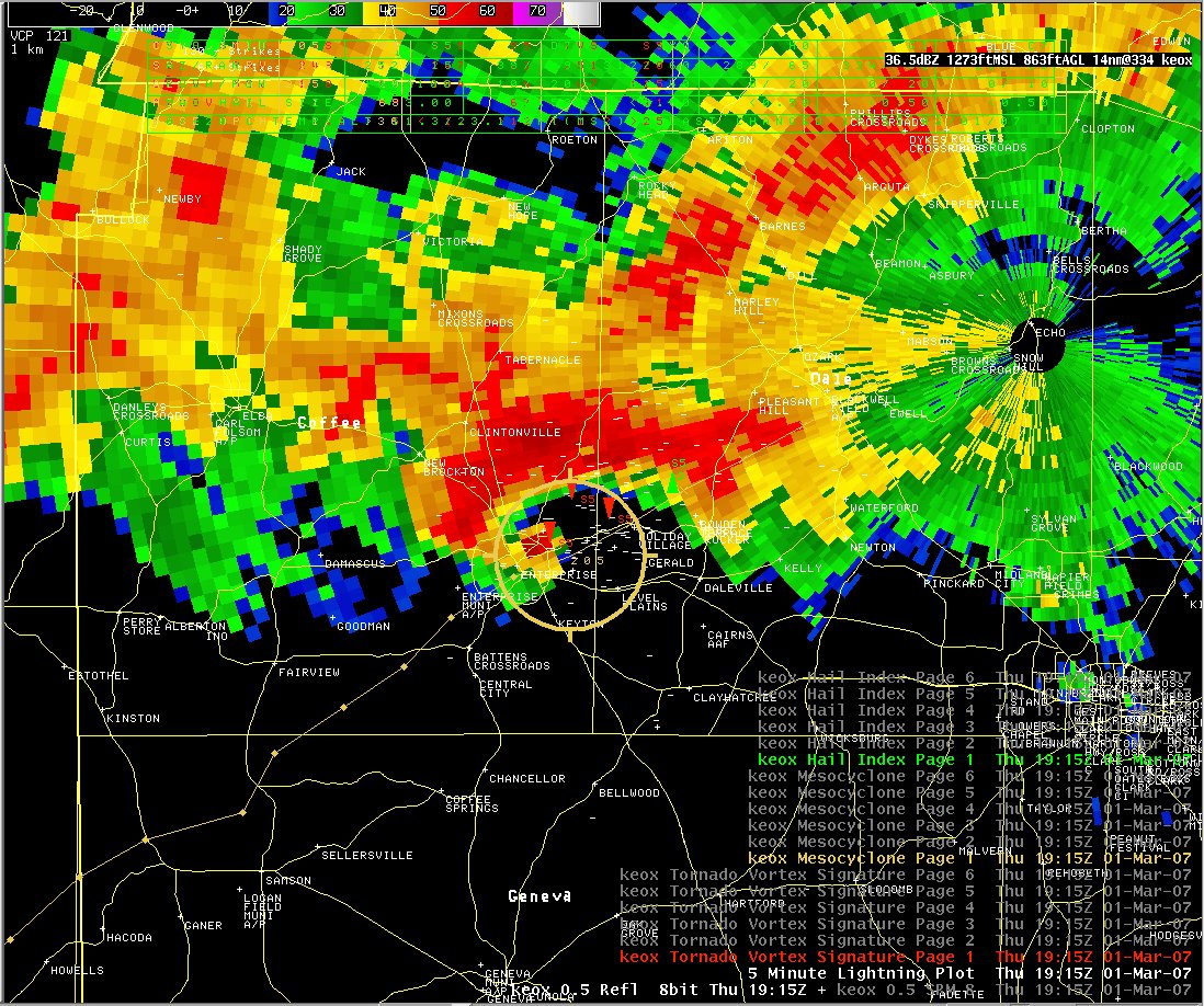
| Svr Wx / Tornado | March 1st - 2nd 2007 |
Thursday, March 1, through the early morning hours of Friday, March 2, 2007, the NWS Weather Forecast Office in Tallahassee issued 57 warnings included 35 tornado, 19 severe thunderstorm, and 4 special marine warnings. During this time, warnings were issued for two deadly tornadoes, which caused the loss of 15 lives, nine in Enterprise, AL, and six just north of Newton, GA |
| Svr Wx / Tornado | October 27th 2006 |
Apalachicola Waterspout / Tornado A waterspout came ashore and produced F1 tornado damage in Apalachicola. The tornado cut a path approximately 1 mile long and more than 100 yards wide, damaging dozens of structures and hundreds of trees. |
| Svr Wx / Tornado | August 8th 2006 |
Severe thunderstorms erupted over a large portion of the forecast area during the afternoon and evening hours of August 8th 2006. The most significant storm occurred over southern portions of Dale county Alabama near the midland city area where a destructive thunderstorms microburst produced estimated straight-line winds over 70 mph. |
| Tropical Storm | June 13th 2006 |
The 2006 Hurricane Season got off to an early start. Tropical Storm Alberto, the first named storm of the season, made landfall along the Florida Big Bend coast northwest of Adams Beach in Taylor County at approximately 1230 PM EDT, Tuesday, June 13. |
| Svr Wx / Tornado | December 5th 2005 |
Moist, unstable air in advance of a strong cold front produced a couple of damaging F-1 tornadoes across south central Georgia and the Florida Big Bend on Monday, December 5th. The first tornado damaged numerous buildings, including the Worth County Courthouse, in Sylvester, Georgia. The second tornado hopscotched its way across Wakulla County, passing just north of Crawfordville, Florida. |
| Svr Wx / Tornado | March 22nd 2005 |
A strong upper-level weather system in the lower Mississippi Valley coupled with warm, moist, unstable air across southern Alabama, southern Georgia, and the Florida Big Bend and Panhandle produced numerous reports of severe weather across southern Alabama and Georgia. |
| Svr Wx / Tornado | March 20th 2003 |
During the early morning hours of Thursday, March 20, 2003, a deadly tornadic thunderstorm pushed northeastward along a squall line that was crossing the Eastern Florida Panhandle and Southwest Georgia. In its wake, the storm left six people dead, hundreds injured, and a path of destruction that extended from the Panhandle coast all the way into central Georgia. |
| Svr Wx Event | Feb 16th 2003 |
During the early morning hours of Sunday, February 16, 2003, a squall line swept across the NWS WFO Tallahassee County Warning and Forecast Area. |
| Svr Wx / Tornado | March 15th 2001 |
Four tornadoes touched down in eastern portions of the Florida Panhandle and southwestern Georgia during the early morning hours of Thursday, March 15, 2001. One person was killed and 33 were injured during this event, which produced two F2 tornadoes, along with an F1 and an F0. |
| Svr Wx / Tornado | February 14th 2000 |
Sunday evening, February 13 through the early morning hours of Monday, February 14, 2000, NWS WFO Tallahassee issued 52 warnings. These included 25 tornado, 24 severe thunderstorm, and 3 special marine warnings. During this time, warnings were issued for three deadly tornadoes, which caused the loss of 19 lives in three southwest Georgia counties, an event unequaled for south Georgia in nearly 50 years. |


 Follow us on YouTube