| Severe Weather Event of February 16, 2003 |
During the early morning hours of Sunday, February 16, 2003, a squall line swept across the NWS WFO Tallahassee County Warning and Forecast Area. The office issued a total of nine warnings. These included four tornado, one severe thunderstorm, and four special marine warnings. Fortunately, there were no fatalities associated with this event, despite the early hour on a weekend morning. The following is a brief discussion of the severe weather that occurred that morning.
The first Special Marine Warning (SMW) was issued at 0740 UTC (1:40 am CST) for a large cluster of storms out in the Gulf well south of the Panhandle that exhibited strong mesocyclones and frequent intense lightning. By 0948 UTC (3:48 am CST), another SMW was necessary, as the strong storms has moved much closer to shore.
WHUS52 KTAE 160740
SMWTLH
GMZ750-770-160945-

URGENT - IMMEDIATE BROADCAST REQUESTED
SPECIAL MARINE WARNING
NATIONAL WEATHER SERVICE TALLAHASSEE FL
240 AM EST SUN FEB 16 2003

THE NATIONAL WEATHER SERVICE IN TALLAHASSEE HAS ISSUED A

* SPECIAL MARINE WARNING FOR...
  COASTAL WATERS FROM PANAMA CITY BEACH TO DESTIN, FL OUT TO 60NM

* UNTIL 445 AM EST (345 AM CST)

* AT 237 AM EST (137 AM CST)...NATIONAL WEATHER SERVICE DOPPLER RADAR
  INDICATED A CLUSTER OF STRONG THUNDERSTORMS WITH WIND GUSTS OVER 35
  KNOTS 63 MILES SOUTH OF DESTIN...MOVING NORTHEAST AT 35 MPH.

BOATERS SHOULD SEEK SAFE HARBOR IMMEDIATELY AND REMAIN IN PORT UNTIL
THESE THUNDERSTORMS EXIT THE COASTAL WATERS.

LAT...LON 2947 8674 2935 8660 3006 8568 3028 8614

$$

18-WOOL
This warning (see below) stated that one of the strongest storms would move ashore into Tyndall Air Force Base by 1015 UTC (4:15 am CST) and that coastal residents should be alert for the possibility of waterspouts moving ashore. One did just that, tossing about several vehicles on the base around 1000 UTC (4:00 am CST). Another suspected waterspout-turned-tornado blew into Port St. Joe in Gulf County a short time later and damaged a carport, as well as several roofs and porches.
WHUS52 KTAE 160949
SMWTLH
GMZ750-770-161145-

URGENT - IMMEDIATE BROADCAST REQUESTED
SPECIAL MARINE WARNING
NATIONAL WEATHER SERVICE TALLAHASSEE FL
448 AM EST SUN FEB 16 2003

THE NATIONAL WEATHER SERVICE IN TALLAHASSEE HAS ISSUED A

* SPECIAL MARINE WARNING FOR...
  COASTAL WATERS FROM APALACHICOLA TO PANAMA CITY BEACH FL OUT 60NM

* UNTIL 645 AM EST

* AT 440 AM EST (340 AM CST)...NATIONAL WEATHER SERVICE DOPPLER RADAR
  INDICATED A CLUSTER OF STRONG THUNDERSTORMS WITH WIND GUSTS OVER 35
  KNOTS 39 MILES WEST OF EMPIRE MICA WRECK...MOVING NORTHEAST AT 35
  MPH. ANOTHER STRONG CLUSTER OF STORMS WAS LOCATED ABOUT 10 MILES
  SOUTH OF PANAMA CITY AND WILL MOVE ASHORE INTO TYNDALL AIR FORCE
  BASE BETWEEN PANAMA CITY AND MEXICO BEACH BY 415 CST.

BOATERS SHOULD SEEK SAFE HARBOR IMMEDIATELY AND REMAIN IN PORT UNTIL
THESE THUNDERSTORMS EXIT THE COASTAL WATERS.

COASTAL RESIDENTS SHOULD BE ALERT FOR THE POSSIBILITY OF WATERSPOUTS
MOVING ASHORE.

LAT...LON 2927 8608 2912 8599 2934 8501 2974 8507

$$

18-WOOL
Around 1010 UTC (4:10 am CST), another storm exhibited strong gate-to-gate rotational velocity and a tornado warning (see below) was promptly issued at 1017 UTC (4:17 am CST) for Washington County in the Eastern Florida Panhandle.
WFUS52 KTAE 161017
TORTLH
FLC133-161045-

BULLETIN - EAS ACTIVATION REQUESTED
TORNADO WARNING
NATIONAL WEATHER SERVICE TALLAHASSEE FL
417 AM CST SUN FEB 16 2003

THE NATIONAL WEATHER SERVICE IN TALLAHASSEE HAS ISSUED A

* TORNADO WARNING FOR...
  WASHINGTON COUNTY IN FLORIDA
  THIS INCLUDES VERNON...

* UNTIL 445 AM CST

* AT 409 AM CST NATIONAL WEATHER SERVICE DOPPLER RADAR INDICATED A
  DEVELOPING TORNADO 8 MILES SOUTHWEST OF VERNON...MOVING NORTHEAST
  AT 20 MPH.

* THE TORNADO WILL BE NEAR...
  VERNON BY 430 AM CST...

TORNADOES ARE ESPECIALLY DANGEROUS AT NIGHT WHEN THEY ARE DIFFICULT
TO DETECT. IF YOU ARE IN THE WARNED AREA...SEEK REFUGE IN A SMALL
INTERIOR ROOM ON THE LOWEST FLOOR.

RELAY REPORTS OF SEVERE WEATHER TO THE NATIONAL WEATHER SERVICE IN
TALLAHASSEE AT (850) 942-8833.

LAT...LON 3056 8590 3043 8576 3056 8551 3074 8565

$$

18-WOOL
The warning was valid for about a half hour and stated that the tornado would be near Vernon around 1030 UTC. At precisely that time, the local 911 operator for the county reported that windows were blown out of, and shingles blown off, her sister's home in Vernon, with a neighboring house sustaining some damage as well. The tornadic storm continued on into a rural parts of Jackson County Florida, but no additional damage reports were received. The coastal storms weakened as they moved inland into the western Florida Big Bend. However, additional SMWs were necessary as the strong storms marched eastward across the Apalachee Bay between about 1200 and 1500 UTC (7:00-10:00 am EST).
Around 1220 UTC (7:20 am EST), a storm in Gadsden County, FL, began to rotate and the KTLH Doppler radar began to indicate a persistent mesocyclone. The storms then crossed the border into Decatur County, GA. Calls to EM and 911 officials in these counties confirmed our suspicions that the circulation had not lowered to the ground. However, by the time the storm reached northern Grady County, it had taken on a classic bookend vortex signature.
A tornado warning (see below) was issued at 1309 UTC (8:09 am EST) for northern Grady County and upstream Mitchell County, GA, near the sites of the deadly F3 tornadoes that swept the area in February 2000.
WFUS52 KTAE 161309
TORTLH
GAC131-205-161345-

BULLETIN - EAS ACTIVATION REQUESTED
TORNADO WARNING
NATIONAL WEATHER SERVICE TALLAHASSEE FL
809 AM EST SUN FEB 16 2003

THE NATIONAL WEATHER SERVICE IN TALLAHASSEE HAS ISSUED A

* TORNADO WARNING FOR...
  NORTHERN GRADY COUNTY IN GEORGIA
  MITCHELL COUNTY IN GEORGIA
  THIS INCLUDES PELHAM...

* UNTIL 845 AM EST

* AT 805 AM EST NATIONAL WEATHER SERVICE DOPPLER RADAR INDICATED A
  DEVELOPING TORNADO 13 MILES SOUTHWEST OF PELHAM...OR ABOUT 10 MILES
  NORTHWEST OF CAIRO...MOVING NORTHEAST AT 35 MPH.

* THE TORNADO WILL BE NEAR...
  PELHAM BY 825 AM EST...

IF YOU ARE IN THE PATH OF THIS TORNADO...ABANDON YOUR MOBILE HOME FOR
A REINFORCED SHELTER.

LAT...LON 3104 8436 3095 8427 3115 8402 3126 8415

$$

22-BARRY
The warning was valid until 1345 UTC (8:45 am) and stated the tornado would be near Pelham by around 1325 UTC (8:25 am EST).
Georgia Emergency Management NWS investigators later determined that a tornado touched down in the northernmost portion of Grady County, just south of County Line Rd, and then traveled northeast into Mitchell County as an F1 tornado. The damage path of the Grady/Mitchell County tornado, a schematic of the debris field, and its intensity based on the Fujita scale can be found in Figure 3.

As can be seen, several mobile homes were damaged or destroyed. A couple of permanent homes also sustained structural damage, and many trees were felled in the area. Several photos of the debris field have been provided courtesy of the Georgia Emergency Management Agency. The vortex sucked the grass right out of the ground as it skipped across extreme northern Grady County: 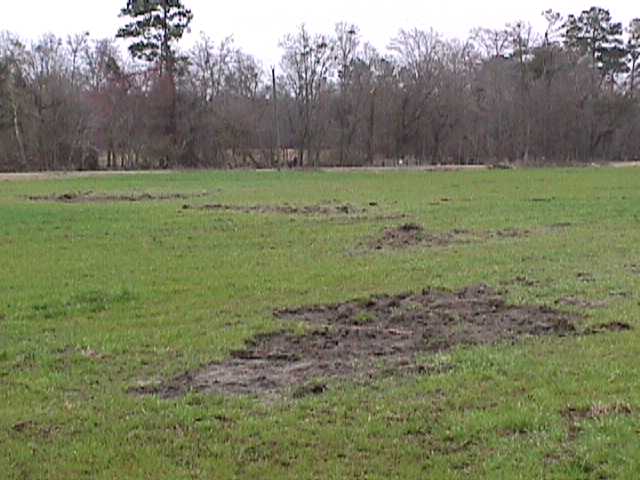
The tornado then tracked across Wade Rd. and Highway 262. The most extensive damage occurred on or near the Harper property on Wade Rd. Mr. Harper read the warning as it scrawled across the screen on WALB-TV out of Albany, GA. He alerted his wife and they decided to leave the home for a low, protected area on their property. Unable to escape the approaching tornado, they dove beside their parked automobile., located just a few yards from their mobile home. The car shifted a few feet briefly pinning Mrs. Harper underneath. She escaped with bruises.

Image shows what was left of their trailer after the tornado passed. Although they suffered the great loss of their property, timely warnings and rapid dissemination by the local television station likely saved their lives.


 Follow us on YouTube