Widespread Flooding and Multiple Tornadoes Impact the Tri-State Area
Event Overview
A significant flooding and severe weather event unfolded over the tri-state area last weekend as showers and thunderstorms spread northward across the area for multiple days. During this time heavy rain and strong storms prompted a total of 6 Flash Flood Warnings, 28 Severe Thunderstorm Warnings, and 9 Tornado Warnings. The most noteworthy impact over the weekend was heavy precipitation. Widespread rainfall totals reached 5-7 inches throughout our area with some localized heavier amounts. This resulted in flash flooding and river flooding across numerous counties. A list of rainfall totals from the multi-day event is provided here. In addition, four tornadoes touched down, including one in southeast Alabama, two in southwest Georgia and one in the Florida Big Bend.
 |
| Storm Reports from the multi-day event |
Synoptic Overview
The event began Friday morning as a deep-layer high pressure system shifted east across northern Florida. This enhanced southerly flow and began fueling the region with warm moist air from the Gulf of Mexico. Meanwhile, a mid-level short wave moved east across the Gulf towards the Florida Panhandle. By Saturday morning, low level convergence, enhanced by the shortwave, facilitated convection to develop over the area. For the next day, a combination of a very moist atmosphere and the forcing enhanced by a slowly northward propagating warm front led to abundant rainfall.
Although convergence along the warm front weakened as it moved north overnight, southerly flow intensified ahead of a fast moving mid-latitude cyclone which was propagating east across the country. On Sunday morning’s sounding, Tallahassee measured a Precipitable Water (PWAT) value of 2.05” (average PWAT for this time of year 1.28”) breaking the old daily record of 1.87”. By Sunday night, the cold front ahead of the next system began to make its presence felt in the region. Enhanced forcing along the front, a record breaking moist air mass, and training of showers and thunderstorms produced another round of heavy precipitation. Precipitation totals increased dramatically over the region. Philema in Lee County observed +10” of rain throughout the event and additional observations are provided in the table below.
 |
| Full list of rainfall observations is available here |
Heavy precipitation led to abundant river flooding and flash flooding across our area. Most rivers reached action stage by the end of the event. Multiple events reached action stage while the Chipola River in Altha and Ichawaynochaway Creek in Milford reached moderate flood stage.
 |
| Rainfall Totals from 1pm EST December 1 to 7pm EST December 3 |
Houston County Tornado
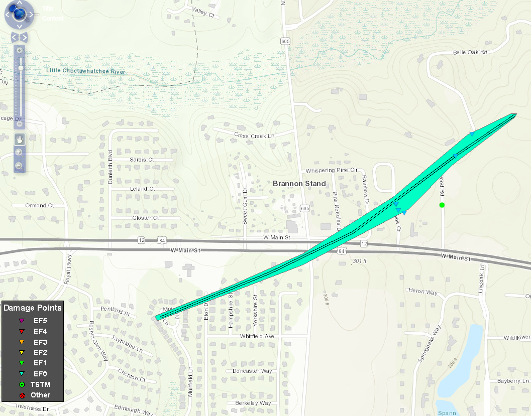
Damage, consisting of a few dozen snapped pine trees, began near the end of the Muirfield Lane in Highland Oaks. The tornado traveled to the northeast and crossed Hwy 84 near its intersection with Brannon Stand Road where a power pole was snapped and several trees were downed. The tornado then crossed through the whispering pines subdivision, downing a few dozen trees and damaging fences. The most significant damage was noted along Chloe Court, where in addition to tree damage, a couple of homes suffered roof damage and a car was flipped over from a driveway into a yard. The tornado continued traveling northeast and the last evidence of damage was five or six snapped trees along Westwood Road.
| Rating: | EF-0 |
| Estimated Peak Wind: | 85 mph |
| Path Length (statue): | 1.06 miles |
| Path Width: | 75 yards |
| Fatalities: | 0 |
| Injuries: | 0 |
| Start Date: | 12/02/2018 |
| Start Time: | 1:49 AM CST |
| Start Location: | 31.2361, -85.4868 |
| End Date | 12/02/2018 |
| End Time: | 1:51 AM CST |
| End Lat/Lon: | 31.2448, -85.4721 |
 |
 |
 |
 |
 |
| Damage to a fence | Tree down due to tornado | Tree down due to tornado |
Madison County Tornado
An EF-1 tornado with 100 mph winds touched down in Madison County early Monday morning. The path was 2.16 miles. One mobile home was shifted off its blocks. A small outbuilding was swept off its foundation and rolled several feet. Another mobile home nearby was shifted slightly and the blocks underneath are now tilted. Considerable tree damage was present throughout the path.
| Rating: | EF-1 |
| Estimated Peak Wind: | 100 mph |
| Path Length (statue): | 2.16 miles |
| Path Width: | 279 yards |
| Fatalities: | 0 |
| Injuries: | 0 |
| Start Date: | 12/03/2018 |
| Start Time: | 2:32 AM EST |
| Start Location: | 30.6087, -83.485 |
| End Date | 12/03/2018 |
| End Time: | 2:37 AM EST |
| End Lat/Lon: | 30.6304, -83.459 |
 |
 |
 |
 |
 |
| Tree down in Madison County | Structural damage in Madison County | Damage to mobile home from tornado |
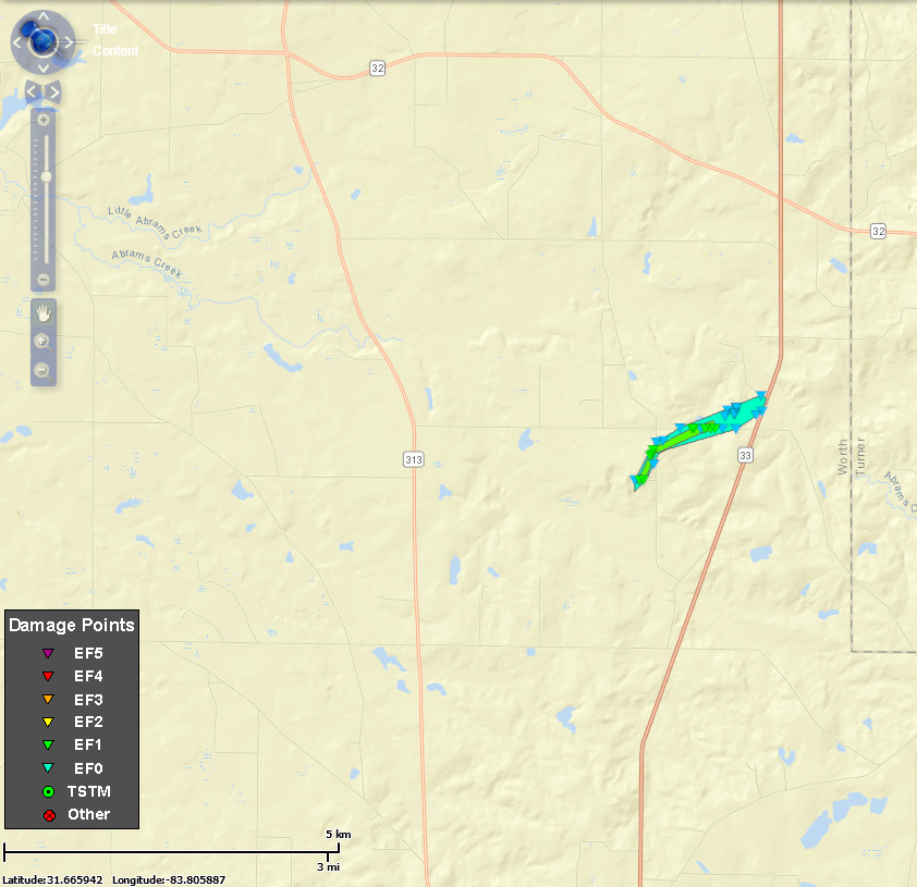
Worth County Tornado
Tornado touched down just south of Hobby Hill Road and moved northeast across Medders Road and Hilltop Road before dissipating at Highway 33. The storm caused minor damage to a couple of manufactured homes and more significant damage to outbuildings. EF-1 level damage to several stands of pine trees was noted, with maximum winds estimated at 105 mph.
| Rating: | EF-1 |
| Estimated Peak Wind: | 105 mph |
| Path Length (statue): | 1.55 miles |
| Path Width: | 350 yards |
| Fatalities: | 0 |
| Injuries: | 0 |
| Start Date: | 12/02/2018 |
| Start Time: | 2:46 AM EST |
| Start Location: | 31.6445, -83.831 |
| End Date | 12/02/2018 |
| End Time: | 2:50 AM EST |
| End Lat/Lon: | 31.6567, -83.8104 |
 |
 |
 |
 |
 |
| Trees snapped from tornado | Damage to tin roof | Damage to mobile home from tornado |
Tift County Tornado
Tornado touched down near Ty Ty Sparks Road north of US 319 and traveled northeast across Flat Ford Road and Keith-Fletcher Road. The tornado lifted just after crossing Ty Ty Omega Road. Damage was primarily confined to irrigation systems and trees. A substation sustained some damage was well.
| Rating: | EF-0 |
| Estimated Peak Wind: | 85 mph |
| Path Length (statue): | 1.86 miles |
| Path Width: | 600 yards |
| Fatalities: | 0 |
| Injuries: | 0 |
| Start Date: | 12/02/2018 |
| Start Time: | 9:19 AM EST |
| Start Location: | 31.339, -83.6184 |
| End Date | 12/02/2018 |
| End Time: | 9:25 AM EST |
| End Lat/Lon: | 31.3595, -83.5979 |
 |
 |
 |
 |
 |
||
| Trees snapped from tornado | Overturned irrigation pivots |
|


 Follow us on YouTube