 |
 |
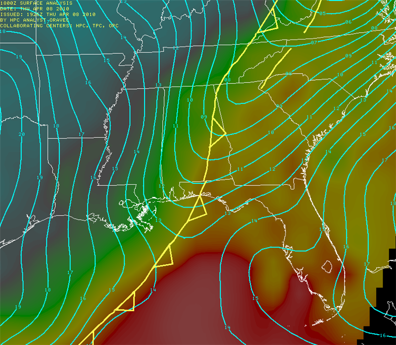
Fig. 1) MSLP and surface cold front at 1800Z (left), and 500mb Heights and relative vorticity (right).
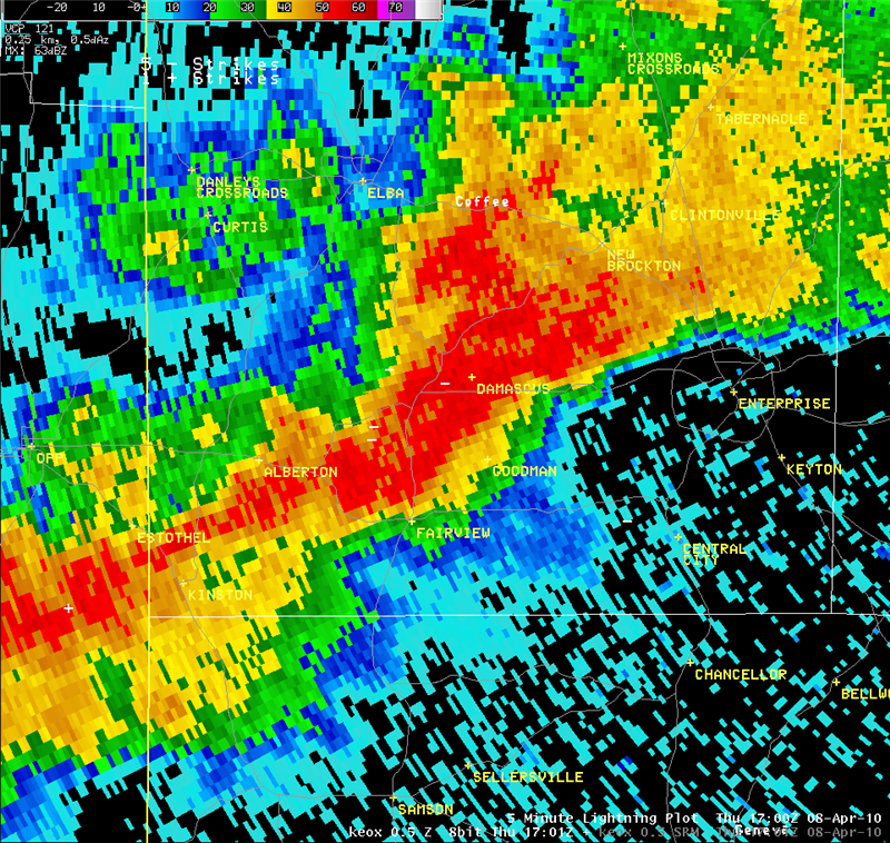
The first tornadic thunderstorms across the forecast area developed early in the afternoon over Coffee County Alabama. A weak EF-0 tornado first touched down just east of Alabama Highway 87. The next area of damage was reported east northeast from this initial touchdown along CR-611 where a barn was destroyed along with several trees snapped. The final area of damage was reported North of Alabama Highway 134 where a roof was taken off the porch of a house along with a portion of the roof over the kitchen. Figure 2 shows the 0.5 degree reflectivity and storm relative velocity from the KEOX WSR-88D radar shortly before the tornado. A pronounced rotational couplet (mesocyclone) is seen in the velocity image near Damascus, Alabama.
 |
 |
Fig. 2) Tornadic storm over Coffee County, AL at 1700 UTC April 8th, 2010. KEOX 0.5 deg reflectivity (left), and Storm Relative Motion (SRM) (right).
The second tornado of the day developed from a fast-moving storm that crossed Gadsden County, Florida during mid-afternoon. This tornado was also brief and rated EF-0. The tornado touched down in the vicinity of Quincy, Florida, just southwest of Florida Highway 267 and tracked northeast onto Holt Lane. Damage southwest of Holt Lane was limited to trees either snapped or uprooted. A few structures were damaged on Holt Lane, primarily due to falling trees. One outbuilding lost its roof as a result of the tornado. The tornado continued northeast crossing Interstate 10 near exit 181. Trees were reported uprooted or snapped on both sides of the Highway. The tornado appears to have lifted shortly after crossing the Interstate. Figure 3 shows storm relative velocity data from the KTLH WSR-88D radar as the mesocyclone that spawned the tornado rapidly tightens and then weakens while passing just Southeast of Quincy, Florida.

1822 UTC
|

1828 UTC
|

1833 UTC
|

1839 UTC
|
Fig. 3) Progression of SRM images from the KTLH WSR-88D radar as the tornado develops and dissipates near Quincy, FL.
Additional thunderstorms produced scattered damage across the eastern Florida Big Bend along the Interstate 10 corridor. The most widespread damage occurred near the community of Cherry Lake in Madison County, where numerous trees and powerlines were reported down due to straight-line winds. Figure 5 shows the Cherry Lake storm approx. 15 minutes before the damaging winds occurred. Notice the storm relative velocity image on the left showing a distinct Mid-Altitude Radial Convergence (MARC) signature at around 9000 feet AGL. The radial convergence was approx. 60 knots indicating the likelihood of severe winds at the surface in the near future.
 |
 |
Fig. 5) Cherry Lake, FL storm from the KTLH WSR-88D radar. Reflectivity image (right) and SRM (left) showing a distinct MARC signature.
View the Local Storm Report Summary (LSRTAE) from April 8th, 2010
Photos: NWS Tallahassee


 Follow us on YouTube