National Weather Service United States Department of Commerce


The National Weather Service in Tallahassee issues fire weather forecasts for the Florida Big Bend, eastern portions of the Florida Panhandle, Southeast Alabama, and Southwest and South Central Georgia. Spot fire weather forecasts are issued as necessary for wildfires, and for prescribed burns on federal or state lands, in the above areas. 
Request or View a Spot Forecast
Official, government, and emergency personnel use only.  Click here for instructions on how to request a spot forecast and run a HYSPLIT (plume concentration).
 
?

Questions or comments about the NWS Tallahassee fire weather program?  Email Andy Haner, fire weather focal point.

 Local Forecast Graphics MORE 

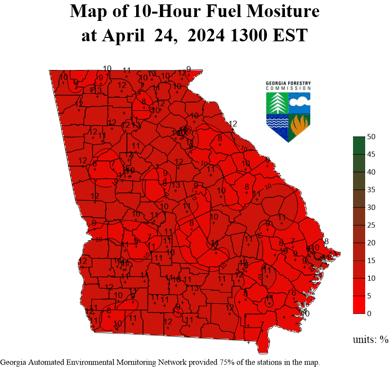
We are in the process of evaluating future replacements for these graphics. Alternate links to these data can be found in the title of each respective element.

Additionally, a useful (point-forecast) resource for your fire weather planning needs is available here.

Period 1 Period 2 Period 3 Period 4
Max Relative Humidity - Min Relative Humidity
Min RH Period 1 Min RH Period 2 Min RH Period 3 Min RH Period 4
10 Meter Winds 
20 ft Wind Period 1 20 ft Wind Period 2 20 ft Wind Period 3 20 ft Wind Period 4
Transport Winds
Transport Wind Period 1 Transport Wind Period 2 Transport Wind Period 3 Transport Wind Period 4
Mixing Height (No Available Replacement At This Moment)
Mixing Height Period 1 Mixing Height Period 2 Mixing Height Period 3 Mixing Height Period 4
 Observations

RAWS Data TAEJAXMOBNational
Florida Forest Service Current Conditions

 
 Local Fire Weather Products

Fire Weather Planning Forecast (FWF)
Red Flag Warning/Fire Weather Watch (RFW) (if any in effect)
Tri-State Red Flag Criteria (for FL, GA and AL)
Fire Danger Rating Forecast (WIMS)
3-Hour Graphical Forecasts

 Other Fire Weather Links

SPC Fire Weather Outlook: Day 1Day 2Days 3-8
Fire Mapping: GeoMAC Wildfire Mapping
NESDIS Hazard Mapping System Fire and Smoke Product
NESDIS Satellite Fire Monitoring
U.S. Forest Service MODIS Active Fire Maps
KBDI: Regional Overview.
Florida Energy Release Component (ERC) (scroll down page)
GA 10-hr Fuel Moisture (MapPoint Data)

Current Fires and/or Burn Authorizations

 
 State & Federal Agency Links

USFS: US Fire Danger Map 
Florida Forest Service: HomepageFire Weather Page
Georgia Forestry Commission
Alabama Forestry Commission
National Interagency Fire Center
U.S. Forest Service: HomepageFire & Aviation Management
Emergency Management: FloridaGeorgiaAlabama
Southern Area Coordination Center (SACC) - Incidents
State Operating Plans: FL PDFGA PDF • AL PDF

 Drought & Precipitation Analysis Links
Drought Monitors: National  Regional
 Weather Calculator
Relative HumidityHeat IndexWind Chill