| Tropical Storm Fay Event Summary |
Please see the final Tropical Cyclone Report on Tropical Storm Fay from the National Hurricane Center.
Tropical Storm Fay will likely go down as one of the most prolific rain producers in our area. Rainfall totals exceeding 20 inches in some locations have created record floods on area rivers and created flooding in Tallahassee and surrounding cities that has not been seen in many years, if ever (Figure 1). A post tropical cyclone report summarizes the rainfall totals produced by TS Fay.

Figure 1. Current estimates of total rainfall across the forecast area associated with the passage of Tropical Storm Fay through 8 AM EDT Sunday morning (August 24th).
Tropical Storm Fay began over the waters of the Caribbean on Friday, August 15. Fay began a trek over the islands of Hispanola and Cuba before turning northward and making landfall near Key West, Florida on Monday, August 18th as a strong tropical storm. Fay continued northward on the 18th and made its second landfall during the early morning hours of the 19th in Southwest Florida near Naples (Figure 2).

Figure 2. Early track of Tropical Storm Fay as it crossed the central and western Caribbean.
A large ridge of high pressure began building north of the region on Tuesday, August 19th. This high pressure area stalled the northward progress of Fay and essentially rendered the system stationary over East Central Florida north of Melbourne. Over the next 48 hours, Fay dumped over 20 inches of rain in portions of East Central Florida before slowly moving northward late on Wednesday, August 20th. Due to the strengthening ridge of high pressure, Fay slowly began a turn to the northwest and made its third landfall near Daytona on the 21st of August (Figure 3).
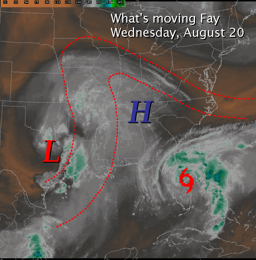
Figure 3. Upper level steering currents from August 20th that forced Tropical Storm Fay to stall along the east coast of Florida.
Throughout the day on Thursday, Fay moved slowly across northern Florida, producing widespread heavy rain across southeastern Georgia and northern Florida. On Friday, August 22nd, Fay began to approach the waters of Apalachee Bay while moving slowly westward. With heavy rainfall beginning over the region late in the day, this was the beginning of a heavy rainfall event for much of southwestern Georgia and the Florida Big Bend (Figure 4).

Figure 4. Steering currents that eventually forced Tropical Storm Fay to move back west across northern Florida from August 21st through the 23rd.
Fay emerged into Apalachee Bay late Friday night and made its fourth landfall in Florida on Saturday, August 23rd near Carrabelle, Florida. By morning, Fay had tapped into Gulf of Mexico moisture. A large feeder band began affecting areas east of the Apalachicola River in the morning and spreading into southwestern Georgia by afternoon. More intense bands developed and trained over the same locations for several hours on Saturday producing extremely high rainfall rates and precipitation totals (Figure 5).
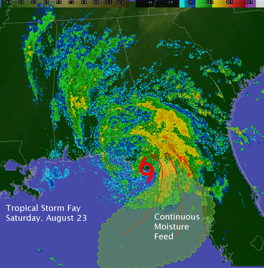
Figure 5. Radar image from Saturday morning August 23rd showing the intense feeder bands of rainfall into the Florida Big Bend and Southern Georgia.
By Sunday, August 24th, Fay had weakened to a depression and continued moving westward into eastern Mississippi. In the days ahead, major and record flooding occurred along some rivers in the Florida Big Bend.
Photos from Tropical Storm Fay. Click images for larger versions.


1. Forecasters Kelly Godsey and Bryan Mroczka (seated) discuss a tropical storm local statement being prepared on Tropical Storm Fay.
2. The view from the entrance to the James J. Love Building at Florida State University, home to the National Weather Service Tallahassee, during the height of TS Fay on Saturday, August 23, 2008.
3. A screen capture of a forecaster workstation from the afternoon of August 23rd. The main panel displays a storm-relative velocity image from the Tallahassee WSR-88D (KTLH) at 2111 UTC (5:11 pm EDT) August 23, 2008. Note the two tornadic cells in Jefferson County, east of Tallahassee.


4. A screen capture from afternoon of August 23rd. The main panel displays a storm-relative velocity image from KTLH at 2212 (6:12 pm EDT) August 23, 2008. Two tornadic cells are still evident in Jefferson County, Florida. A tornado was spotted briefly touching down west of Capps around this time.
5. Flood waters from a swollen Lake Ella approach North Monroe Street in Tallahassee and engulf businesses in the cottages on the west side of the lake.
6. Flood waters wash out a portion of Weeping Willow Way in eastern Leon County.


7. Senior Service Hydrologist Joel Lanier analyzes hydrographs and coordinates with the Southeast River Forecast Center in Peachtree City, GA, concerning projected flood crests on area rivers.
8. Flooding on the Ochlockonee River south of Havana, Florida. Major flooding occurred on the Ochlockonee River, with the Havana gage missing its record crest by just under a foot and a half.
9. Flooding on the Ochlockonee River south of Bloxham, Florida.
Images: NWS Tallahassee


 Follow us on YouTube