| Severe Weather of March 7, 2008 |
A brief, but extensive severe weather episode occurred across the Florida Big Bend during the morning of March 7, 2008. There were widespread reports of straight line wind damage across the region, with three tornadoes reported, two confirmed by NWS survey teams. There was also some urban street flooding in Tallahassee, followed by some river flooding in the ensuing days. SPC's storm report archive summarizes damage that occurred across the region.
The first wind damage reports of the morning came in from Franklin County around 6:30 AM EST, with trees and power lines downed across the county. This bowing line of storms that caused the Franklin County damage is shown in Figure 1 as it crossed Wakulla County, where up to 30 trees toppled. When a line of thunderstorms bows out like this, it often produces a large area of straight line wind damage of the type reported in these two counties. However, meteorologists know to look at the northern part of the bow, often described as a "bookend vortex," to look for signs of rotation that can produce a tornado.

Figure 1. Reflectivity image from the Tallahassee WSR-88D (KTLH) at 1202 UTC (7:02 am EST) March 7, 2008. Severe thunderstorm warning polygons are overlaid in yellow. Click on the image for a larger view.
Indeed, a tornado did form in this area. A tornado warning was issued for Leon and Jefferson Counties at 7:05 AM EST. Twenty-five minutes later, a EF-1 tornado with estimated sustained winds at 90 mph, touched down in the community of Capitola. Figure 2 shows the damage path of the tornado. Figure 3 shows the radar reflectivity image from the Tallahassee Doppler radar a few minutes after the tornado hit Capitola. Figure 4 shows the storm-relative velocity image from the same time. Note the couplet near Interstate 10 just north of Capitola. Figure 5 shows damage sustained by a home in Capitola. Note the large tree snapped in half in the background.

Figure 2. Track of the EF-1 tornado that touched down in Eastern Leon County, FL, on March 7, 2008. The shaded oval indicates the damage path. Click on the image for a larger view.

Figure 3. Reflectivity image from the Tallahassee WSR-88D (KTLH) at 1225 UTC (7:25 am EST) March 7, 2008. Tornado warning polygons are overlaid in red. Click on the image for a larger view.
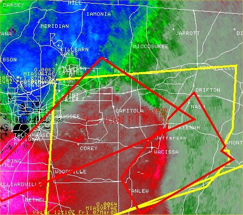
Figure 4. Storm-relative velocity image from the Tallahassee WSR-88D (KTLH) at 1225 UTC (7:25 am EST) March 7, 2008. Tornado warning polygons are overlaid in red. Click on the image for a larger view.

Figure 5. A home and trees damaged by the EF-1 tornado that struck Capitola, FL, in eastern Leon County on March 7, 2008. Click on the image for a larger view.
A severe thunderstorm developed over the northeast Gulf of Mexico south of the Big Bend. A special marine warning was issued at 6:50 AM EST and was in effect until 8:45 AM. As the storm moved east, a large mesocyclone developed. The track of this mesocyclone is shown in Figure 6. The warning was updated at 7:40 AM and continued to mention the possibility of a tornadic waterspout with the storm. A severe thunderstorm warning was issued for Taylor, Dixie and Lafayette Counties at 8:04 AM. As the storm neared the coast, the warning was upgraded to a tornado warning and the pathcast called for the tornado to be near Keaton and Dekle Beaches at 8:30 AM. Between 8:30 and 8:36 AM, the tornado came ashore into Keaton Beach. Figure 7 shows the storm-relative velocity image from the Tallahassee doppler radar close to the time the tornado hit Keaton Beach. The tornado warning area is outlined in red. Figure 8 shows the track of the tornado. A storm survey crew assessed the damage produced by this tornado to be that of an EF-2, with estimated maximum sustained winds of 120 mph. Figure 9 shows a home that was destroyed by the tornado.

Figure 6. Track of the parent mesocyclone that spawned the EF-2 tornado that came ashore into Keaton Beach, FL, on March 7, 2008. Click on the image for a larger view.

Figure 7. Storm-relative velocity image from the Tallahassee WSR-88D (KTLH) at 1329 UTC (8:29 am EST) March 7, 2008. Tornado warning polygons are overlaid in red. Click on the image for a larger view.

Figure 8. Track of the EF-2 tornado that came ashore into Keaton Beach, FL, on March 7, 2008. The shaded oval indicates the damage path. Click on the image for a larger view.

Figure 9. A home that was destroyed by the EF-2 tornado that struck Keaton Beach, FL, in Taylor County on March 7, 2008. Click on the image for a larger view.


 Follow us on YouTube