| Hail Storm Outbreak of March 26-27, 2011 |
Two outbreaks of large hail-producing supercell thunderstorms occurred over the weekend of March 26-27, 2011. The number of supercells, structure of the storms, and number of reports of large hail received over this two-day event is unprecedented in this forecast area and reminiscent of events that occur out in the plains. A synopsis of this event, authored by WFO TAE Senior Forecaster Jeff Fournier, is available here. There were also two summary preliminary local storm reports issued for these events which contain particulars for each report of severe weather received over the weekend. Below, we will highlight some Doppler radar imagery depicting severe storms across the region with a focus on signatures that helped in the warning process. We will also show a few photos of actual hailstones that fell from these storms and some pretty impressive pictures of wall clouds sent in by our SKYWARN spotter network. Figure 1 depicts all of the severe weather reports during the two-day event. As can be easily seen, the overall performance of the warning forecasters was quite good. Overall event lead time was 23 minutes.

Figure 1. Reports of severe weather from March 26-28, 2011. Locations of reported severe weather are shown by the icons.
Figure 2 shows a supercell over Miller County GA moments before it produced 1.75" (golf ball size) hail. Notice the classic supercell structure on base reflectivity, and the defined bounded weak echo region (BWER) on the 1.5-deg tilt (upper right panel).

Figure 2. Multi-tilt reflectivity images from the KTLH Doppler radar at 12:45 PM EDT, March 26, 2011. The tilts increase from left to right and top to bottom.
Figure 3 shows a classic supercell with a hail signature in northeast Decatur County GA. Note the well-defined weak echo region (WER) through several levels. Figure 4 shows several hailstones that fell during the event, notably larger than a dime. Figure 5 shows a tree that was felled by straight-line winds from this storm.

Figure 3. Multi-tilt reflectivity image from the KTLH Doppler radar showing a supercell displaying severe hail signatures in Decatur County GA at 2:15 PM EDT on March 26, 2011.

Figure 4. Hailstones that fell in northern Decatur County GA on March 26, 2011.
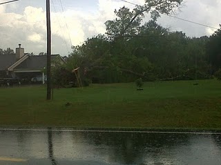
Figure 5. A tree that was felled by straight-line winds in northern Decatur County GA on March 26, 2011.
Figure 6 shows a supercell with a well-defined three body scatter spike (TBSS) approaching Georgetown in Quitman County GA. This storm produced large hail and a confirmed EF-0 tornado several minutes later. This cell then tracked eastward across Randolph County producing large hail and an EF-1 tornado near the town of Benevolence, GA. Figure 7 shows some of the tornado damage. Figure 8 shows about as well-defined a wall cloud and mesocyclone structure that you will see in a supercell in this part of the country. There may even be a tornado tucked behind the tree line. Figure 9 shows reflectivity from the KTLH radar for this same storm for the lowest two tilts. The corresponding storm-relative velocity (SRM) images are on the right. This storm eventually continued east across Terrell County with an as yet unconfirmed tornado touchdown there as well.
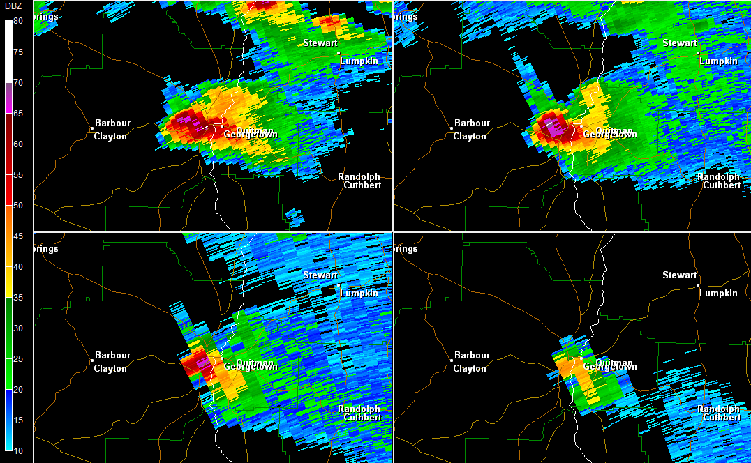
Figure 6. Multi-tilt reflectivity image from the KTLH Doppler radar showing a supercell displaying a TBSS near Georgetown in Quitman County GA at 6:30 PM EDT on March 26, 2011.
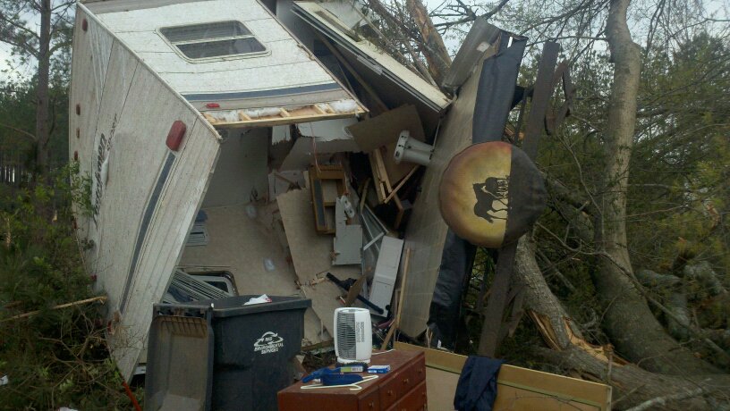
Figure 7. Damage from an EF-1 tornado that touched down near Benevolence, GA, during the evening of March 26, 2011.

Figure 8. A wall cloud in Randolph County that spawned an EF-1 tornado on March 26, 2011.
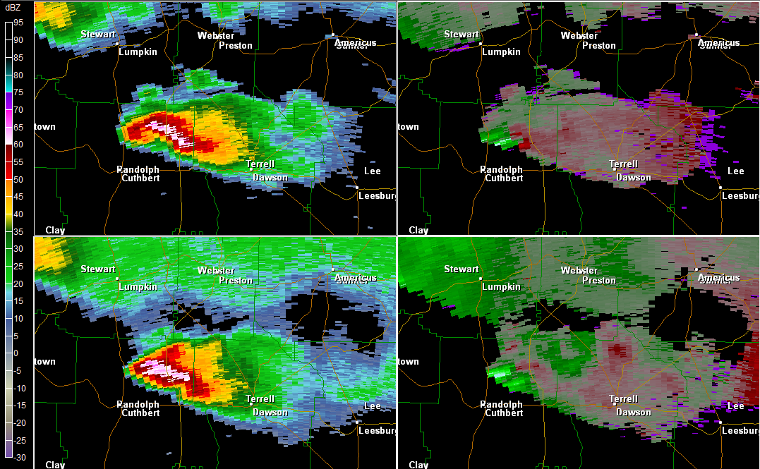
Figure 9. Imagery from the KTLH Doppler radar from 7:22 PM EDT March 26, 2011. Reflectivity imagery from the lowest two slices is shown in the left panels with the corresponding SRM on the right.
A second round of severe hailstorms occurred the next day, on Sunday, March 27. The hail was even more prolific on this day with 27 hail reports coming in to the office. This included numerous reports of golf-ball size hail and even one report of baseball-size hail. One of the first reports of the day came from Grady County GA northwest of Cairo. Figure 10 shows a low precipitation (LP) supercell over the county at 152 PM. Notice the well-defined TBSS indicative of severe hail on the 4.4- and 6.1-degree tilts (lower panels). This storm produced 1.75-inch (golf ball) size hail.

Figure 10. Multi-tilt reflectivity image from the KTLH Doppler radar showing a supercell displaying a TBSS near Cairo in Grady County GA at 1:52 PM EDT on March 27, 2011.
Just under an hour later, a supercell was passing just north of downtown Dothan, AL. Figure 11 depicts the storm. Once again, notice the impressive TBSS, especially in the 1.5-degree tilt. Spectrum Width (SW) data for that same tilt is in lower right panel and shows just how far the hail spike extended, indicative of very large hail. 1.75" hail was reported, with property damage from severe straight line winds. Figure 12 shows a photo of some hail on the ground. Figure 13 shows that the hail did satisfy the NWS severe hail threshold of 1-inch diameter.

Figure 11. Multi-tilt reflectivity image from the KTLH Doppler radar showing a supercell displaying a TBSS just north of Dothan, AL at 2:50 PM EDT on March 27, 2011. Note that the 0.5-degree SW image is displayed in the lower right panel.

Figure 12. Photo showing hail accumulated on the ground north of Dothan, AL on March 26, 2011.

Figure 13. Partially melted hailstones of approximately 1-inch in diameter that fell north of Dothan, AL on March 26, 2011.
At 4:15 PM EDT, another LP supercell tracked across Baker County, GA with a well-defined WER and TBSS as seen in Figure 14. Figure 15 shows this same storm in cross section view. Notice the well-defined WER/BWER indicative of a powerful updraft within this storm.1.75" hail was reported with this cell.

Figure 14. Multi-tilt reflectivity image from the KTLH Doppler radar showing a supercell displaying a TBSS in Baker County GA at 4:15 PM EDT on March 27, 2011.

Figure 15. Reflectivity cross section from the KTLH Doppler radar showing a well-defined WER/BWER indicative of a powerful updraft.
Figure 16 depicts a supercell entering southern Coffee County, AL at 445 PM EDT. Note the definitive severe hail signature with a TBSS at all levels. The SW on the 1.5-degree tilt (lower right) confirms the TBSS concealed withing an area of trailing lighter precipitation (upper right).
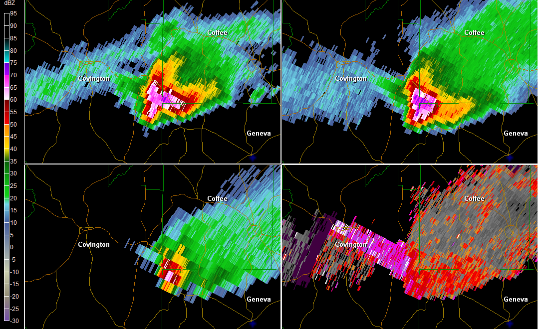
Figure 16. Multi-tilt reflectivity image from the KEVX Doppler radar showing a supercell displaying a TBSS in southern Coffee County, AL at 3:45 PM EDT on March 27, 2011. Note that the 1.5-degree SW image is displayed in the lower right panel.
Figure 17 shows a supercell over southern Miller County, GA. Notice the almost unheard of 80-dBZ return. SW from 3.4-degree tilt is in lower right panel and confirms the large hail TBSS signature hidden within trailing precipitation. One hailstone from this event is shown in the photo in Figure 18. The wall cloud associated with this supercell is shown in Figure 19.

Figure 17. Multi-tilt reflectivity image from the KTLH Doppler radar showing a supercell displaying a TBSS in Miller County, GA at 5:40 PM EDT on March 27, 2011. Note that the 3.4-degree SW image is displayed in the lower right panel.

Figure 18. A SKYWARN spotter holds a hailstone in his hand that fell from a hailstorm on March 27, 2011 in southern Miller County, GA.

Figure 19. A wall cloud associated with a supercell thunderstorm as photographed by a storm chaser in southern Miller County, GA on March 27, 2011.
Thanks to Bryan Mroczka for the radar imagery, Don Van Dyke for the warning polygon map, and Kelly Godsey and Jeff Evans for gathering storm photos. Also, thanks to Jeff Fournier for the linked synopsis.


 Follow us on YouTube