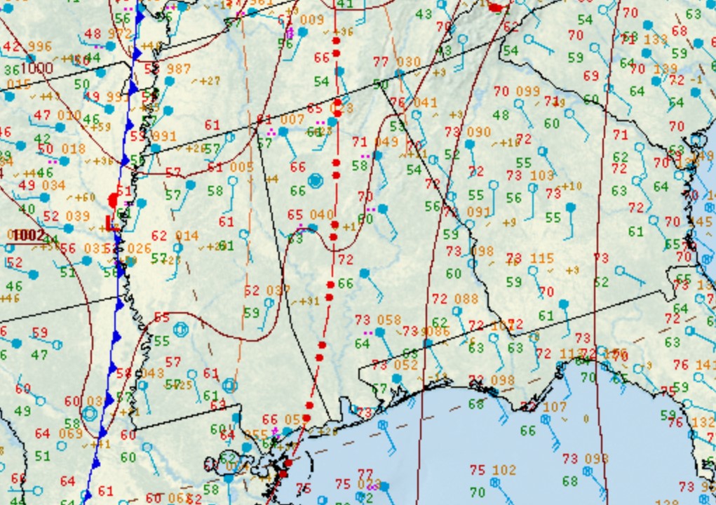
|
Location/Clickable Detailed Summary Link
|
Damage Rating/Estimated Maximum Wind Speeds
|
Injuries/Fatalities
|
Damage Path Length/Width
|
Starting Point/Time
|
Ending Point/Time
|
Greenwood Rd-Livingston Tornado
(Sumter County) |
EF-1
100 mph |
None |
5.62 miles
600 yards |
3 N Old Mallard Airport
32.5479/-88.2675
8:51 pm CDT |
Livingston
32.6004/-88.1957
9:02 pm CDT |
Kirk Tornado
(Pickens/Tuscaloosa Counties) |
EF-1
105 mph
|
None |
16.61 miles
450 yards |
2 SSW Kirk
33.2126/-87.9089
9:02 pm CDT
|
2 E Brownville
33.3938/-87.7207
9:21 pm CDT
|
County Road 72 Tornado
(Greene County) |
EF-1
100 mph |
None |
8.81 miles
275 yards |
2 WNW Tishabee
32.6462/-88.0263
9:10 pm CDT |
3 SE Allison
32.7465/-87.9363
9:21 pm CDT |
Fikes Ferry Rd Tornado
(Perry County)
|
EF-2
115 mph |
None |
6.00 miles
620 yards |
1 NNW Hamburg
32.5475/-87.2944
9:33 pm CDT
|
2 NW Radford
32.6154/-87.2309
9:41 pm CDT
|
Nanafalia Tornado
(Marengo County) |
EF-2
125 mph
(EF-1 in WFO MOB) |
None |
16.96 miles
1350 yards |
1 NE Slater
32.0049/-88.0851
9:35 pm CDT |
Half Acre
32.1959/-87.9047
9:57 pm CDT |
Flag Rd Tornado
(Greene County) |
EF-1
100 mph |
None |
1.17 miles
270 yards |
4 NW Akron
32.9285/-87.7809
9:38 pm CDT
|
4 SSE Knoxville
32.9353/-87.7626
9:40 pm CDT
|
Adler-Montevallo Tornado
(Perry/Bibb/Shelby Counties) |
EF-3
145 mph |
2 Injuries |
29.46 miles
1200 yards |
5 SW Oakmulgee
32.7471/-87.1201
9:53 pm CDT
|
University of Montevallo
33.1086/-86.8612
10:24 pm CDT
|
Holt Lock & Dam Tornado
(Tuscaloosa County) |
EF-1
95 mph |
None |
3.88 miles
400 yards |
1 SSW Holt L&D
33.2447/-87.4525
10:10 pm CDT
|
2 NNE Deerlick Creek Campgrounds
33.2912/-87.4160
10:16 pm CDT
|
Faunsdale Tornado
(Marengo County) |
EF-1
100 mph |
None |
1.03 miles
180 yards |
1 SW Faunsdale
32.4512/-87.6053
10:25 pm CDT
|
Faunsdale
32.4611/-87.5925
10:27 pm CDT
|
|
|
EF-0
85 mph
|
None
|
2.76 miles
175 yards
|
1 ENE Safford
32.2915/-87.3469
10:43 pm CDT
|
3 S Bogue Chitto
32.3170/-87.3108
10:46 pm CDT
|
|
|
EF-1
110 mph
|
None
|
4.52 miles
134 yards
|
4 S Chelsea
33.2649/-86.6431
11:58 pm CDT
|
3 ESE Chelsea
33.3125/-86.5908
12:06 am CDT on Mar 31
|
|
|
EF-0
85 mph
|
None
|
2.89 miles
125 yards
|
1 S Lowndesboro
32.2663/-86.6128
12:09 am CDT on Mar 31
|
2 N Lowndesboro
32.3067/-86.6014
12:13 am CDT on Mar 31
|