| |
Temperatures |
Precipitation |
| Site |
Max |
Min |
Avg |
Norm |
Dep |
Hi |
Lo |
Sum |
Norm |
Dep |
| Fayetteville (NW AR) |
80.8 |
60.4 |
70.6 |
65.3 |
+5.3 |
90 |
50 |
4.86 |
5.89 |
-1.03 |
| Harrison (NC AR) |
79.4 |
60.4 |
69.9 |
66.2 |
+3.7 |
90 |
52 |
4.17 |
4.81 |
-0.64 |
| Jonesboro (NE AR) |
82.5 |
65.4 |
73.9 |
70.4 |
+3.5 |
89 |
57 |
5.70 |
5.21 |
+0.49 |
| Fort Smith (WC AR) |
84.1 |
65.2 |
74.6 |
70.4 |
+4.2 |
95 |
56 |
6.20 |
5.63 |
+0.57 |
| Little Rock (C AR) |
84.8 |
66.4 |
75.6 |
69.9 |
+5.7 |
92 |
56 |
13.30 |
5.08 |
+8.22 |
| Texarkana (SW AR) |
87.0 |
68.0 |
77.5 |
71.6 |
+5.9 |
98 |
60 |
4.69 |
5.10 |
-0.41 |
| El Dorado (SC AR) |
84.3 |
64.5 |
74.4 |
72.0 |
+2.4 |
94 |
55 |
4.88 |
4.81 |
+0.07 |
| Pine Bluff (SE AR) |
85.9 |
67.2 |
76.5 |
71.6 |
+4.9 |
93 |
54 |
6.30 |
4.80 |
+1.50 |
Temperatures were above normal across the state during the month of May, with above normal rainfall seen across much of the area as well. Some portions of northern and western Arkansas picked up below normal rainfall amounts.
| |
| Temperature records broken in May. Check out the records below. |
| Site |
Record High (Date of Occurrence) |
| Monticello |
90T, (5/7), 92 (5/15) |
| Jacksonville/LRAFB |
91T (5/7) |
| Stuttgart |
89 (5/7) |
| Batesville |
88 (5/7) |
May was a busy weather month across the state of Arkansas with things really escalating near the end of the month when numerous tornadoes occurred across northern Arkansas on the 26th. Unfortunately, these tornadoes and associated heavy rain led to several injuries and some fatalities. What was interesting about the active weather and above normal rainfall was that there wasn't much widespread river flooding, which is fairly common during May in Arkansas.
|
|
| In the picture: Soil moisture map of the country. |
Warm conditions were in place for the first few days at the start of the month. Some showers and thunderstorms were noted at times, with a decaying area of shower and storms moving east across the southern half of the state on the 2nd. A more widespread weakening area of rain and thunderstorms progressed across much of the state on the 3rd with some locally heavy rain noted. Northern and northeast Arkansas saw the lowest rainfall amounts with some heavy rainfall totals seen across central into southern parts of the state.
Activity was a little less widespread on the 4th with more precip seen on the 5th. Rain and embedded storms were widespread on the 5th with a long period of soaking rain seen across nearly the entire state. Some rainfall totals were as high as 2 inches just on the 5th. During the evening hours of the 5th, a few strong storms developed across S/SE Arkansas. A weak tornado occurred in Lockesburg (Sevier County) with a couple more storms rotating across SE Arkansas. A funnel cloud was reported in Fountain Hill (Ashley County).
A foggy morning enveloped most of the state on the 6th with a major severe weather day expected across areas to the west of Arkansas. A rare high risk severe weather outlook was issued for portions of OK and KS.
Storms merged into a line and moved into NW Arkansas around midnight on the morning of the 7th and continued east before weakening by daybreak. Some wind damage occurred along with 3 EF1 tornadoes.
Late in the 7th and into the early morning hours of the 8th a few storms developed and became severe across portions of central into eastern Arkansas. One storm produced an EF2 tornado across Hot Springs with additional storms producing damaging wind gusts and large hail into portions of Saline, Pulaski and Lonoke counties.
Additional storms developed during the evening hours of the 8th, but there wasn’t much severe weather across Arkansas. Much more intense storms produced tornadoes and very large hail to the north and east of the state.
|
|
| In the picture: A look at the northern lights from the NWS office at the North Little Rock Airport. |
An impressive geomagnetic storm impacted Earth on May 10th. This led to an impressive display of the northern lights across much of the CONUS and even locations farther to the south. An impressive display was visible across much of Arkansas with mostly clear sky conditions after sunset on the 10th through the early morning hours of the 11th. Dry weather was observed across much of the state through the 11th, temperatures were very warm with daily highs in the 80s to around 90. Widespread cloud cover moved in along with rain and storms returning across southern Arkansas on the 12th into the 13th.
Isolated to scattered showers and storms moved across the state on the 13th into the early morning hours of the 14th as an upper level low slowly rotated from central KS eastward toward northern MO. Coverage wasn’t widespread and a few storms became strong to severe. One storm in southeast Arkansas produced golf ball size hail in Tillar (Drew County) around 9 PM on the 13th. A storm in nearby southern Missouri produced a brief tornado near Hollister on a golf course.
A few showers and storms occurred across mainly the northeast half of the state on the 14th as the upper level storm system moved away from the state.
A few showers and storms occurred on the 15th as well, mainly from northwest to north central Arkansas. This activity developed on a residual boundary from early morning storms that diminished across northeast Oklahoma. Coverage was very sparse and most locations didn’t see any rain, or even much in the way of cloud cover. Temperatures were warm from May 14-15 with highs generally in the 80s both days.
Chances for rain and thunderstorms increased from May 16-17 as a new storm system approached from the west. Most of the heavy rain and severe weather threat remained south of the state. After the rain and storms from May 16-17, dry and hot conditions were noted as high pressure built over the area. Temperatures climbed into the 90s for much of the state from May 18-21.
|
|
| In the picture: Severe weather outlook graphics for the May 24-26 period. |
Dry weather came to an end on the 21st as storms developed across W/NW parts of the state during the evening hours. Thunderstorms became more widespread during the overnight hours and continued into Wednesday the 22nd. A few storms produced wind damage and hail during that period. Throughout the day on the 22nd more storms developed and moved east across the state. Jonesboro recorded a wind gust of nearly 70 mph with other areas seeing locally heavy rain, damaging winds and hail. Additional storms redeveloped during the early morning hours of the 23rd and formed into a line, moving southeast across the state. There wasn’t much severe weather, but locally heavy rain was noted.
Heading into late May, there was a lot to be concerned about in Arkansas. Several potent storm systems were set to traverse the middle of the country. Fronts pushed into the state from the Plains, and then waffled back to the north after the systems exited to the east. The fronts encountered well above average temperatures at times, and moisture levels were almost tropical. Scattered to numerous severe storms were in the forecast.
| Temperature and Precipitation Trends |
| |
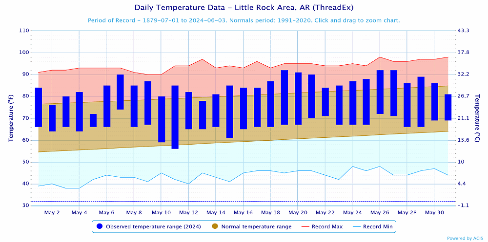 |
| In the picture: Temperatures at Little Rock (Pulaski County). Click to enlarge. |
|
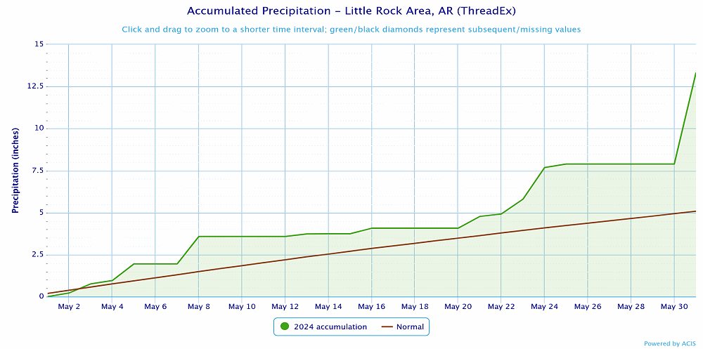 |
| In the picture: Precipitation at Little Rock (Pulaski County). Click to enlarge. |
|
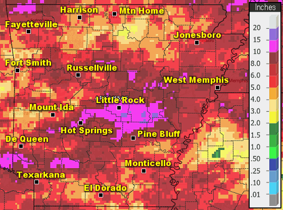 |
| In the picture: Precipitation across Arkansas. |
|
|


