 |
| Storm Reports |
| Are you interested in what happened during a recent event? Check out the report below. |
|
|
 |
Severe Storms on May 6-8, 2024 |
 |
| |
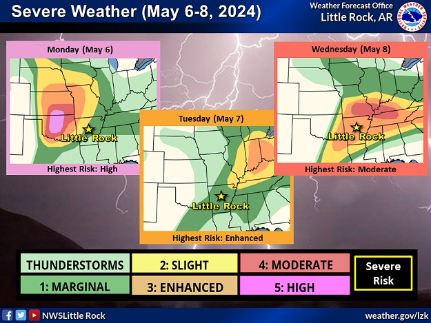 |
| In the picture: There was a risk of severe weather in parts of Arkansas on May 6-8, 2024. |
|
| |
|
A very active weather pattern was in store from the central and southern Plains to the mid-Mississippi, Ohio, and Tennessee Valleys as well as the southeast states from May 6th through the 8th. The event garnered a lot of attention given a very rare high risk of severe weather (the first since March 31, 2023) in portions of Texas and Oklahoma on the 6th, and a moderate risk of severe storms from southern Missouri into central Tennessee on the 8th.
|
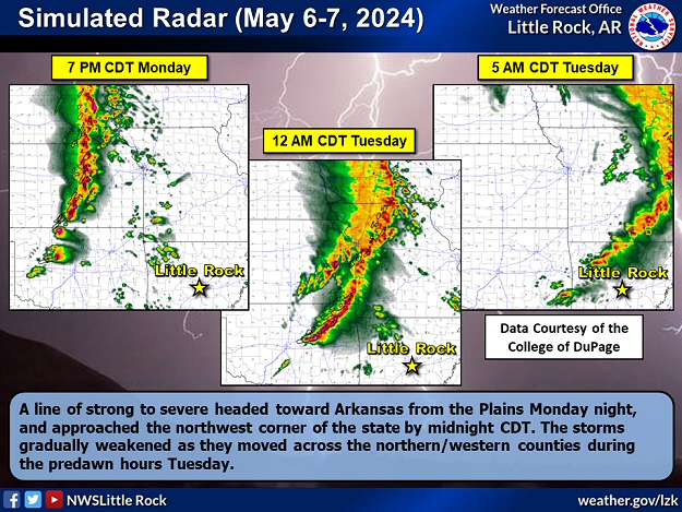 |
| In the picture: Simulated radar showed a line of strong to severe headed toward Arkansas from the Plains during the evening of 05/06/2024. The storms gradually weakened as they moved across the northern/western counties during the predawn hours of the next morning. The data is courtesy of the College of DuPage. |
|
| |
|
During the evening of the 6th, the situation was dire between Osage, OK and Dewey, OK. This is where a supercell (storm with rotating updrafts) spawned a powerful long track (39.1 miles) tornado (rated EF4). One person was killed. The tornado ripped through Barnsdall, OK, and heavily damaged a wax factory and destroyed homes. Eventually, a line of storms overtook the supercell, and the tornado dissipated.
The line arrived in northwest Arkansas during the wee hours of the 7th (between 230 and 330 am CDT), and cranked out a whopping seven more tornadoes in parts of Crawford, Franklin, Madison, and Washington Counties. The strongest of these (rated EF2) was on the ground almost twelve miles from southeast of Stillwell, OK to just east of Odell (Washington County). The other tornadoes were generally weak (rated EF1). Extensive tree damage was noted, and several outbuildings were dismantled. Homes were roughed up from Van Buren to south of Dyer (both in Crawford County), and there was hail up to quarter size not far from Ozark (Franklin County). Storms tended to weaken as they progressed farther to the east.
Later on the 7th, the focus shifted to the northeast. Several strong tornadoes (rated EF2) raked across northern Ohio and southern Michigan (where a first ever Tornado Emergency was issued in the state). In and near Portage, MI, a postal facility and mobile home park were heavily impacted. Closer to home, there was a brief lull, but that was about to change.
|
| A Closer Look at the Tornadoes |
|
Across the country, close to 120 tornadoes were confirmed on May 6th through the 8th, 2024. Of these, only four tornadoes were rated EF3 or higher (3 to 4 percent of the total). Eight of ten tornadoes (82 percent) were weak (rated EF0/EF1). Interestingly, these numbers closely parallel tornado statistics in Arkansas since 2000.
|
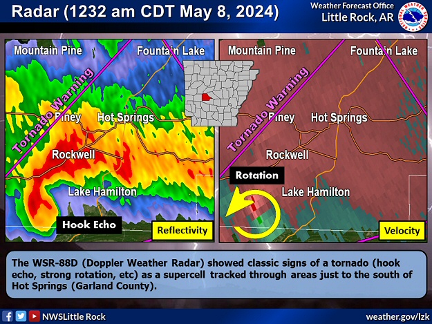 |
| Radar at 1232 am CDT (05/08) | Tornado Track |
| In the pictures: The WSR-88D (Doppler Weather Radar) showed classic signs of a tornado (hook echo, strong rotation, etc) as a supercell (storm with rotating updrafts) tracked through areas just to the south of Hot Springs (Garland County) at 1232 am CDT on 05/08/2024. A Tornado Warning was posted at this time. |
|
| |
|
Between 1215 am and 1230 am CDT on the 8th, a storm to the southwest of Hot Springs (Garland County) showed signs of rotation. A tornado emerged about ten miles southwest of town, and headed toward Lake Hamilton.
|
|
|
| In the video: Damage was extensive along Lake Hamilton (Garland County) as viewed from a drone camera following a tornado (rated EF2) on 05/08/2024. The video is courtesy of the Arkansas Division of Emergency Management (ADEM) via X (formally Twitter). |
|
| |
|
The tornado (rated EF2) pushed mobile homes off their blocks, and battered multiple structures (commercial, industrial, and residential). Most of the damage was done to siding, doors, windows, and roofs. Condos had sections of roofs removed, and large trees fell on some houses. Floating docks were also not spared.
Farther east, there was ping pong ball size hail at Blakemore (Lonoke County), half dollar size hail in west Little Rock (Pulaski County), and quarter size hail just north of Stuttgart (Arkansas County).
|
 |
| In the picture: Widespread clouds and showers/thunderstorms cooled and stabilized the atmosphere in much of Arkansas during the morning/early afternoon of 04/28/2024. Toward evening, more unstable air tried to build into the state from the south/west. Tornado Watches were posted in the southern/western counties as a result. |
|
| |
|
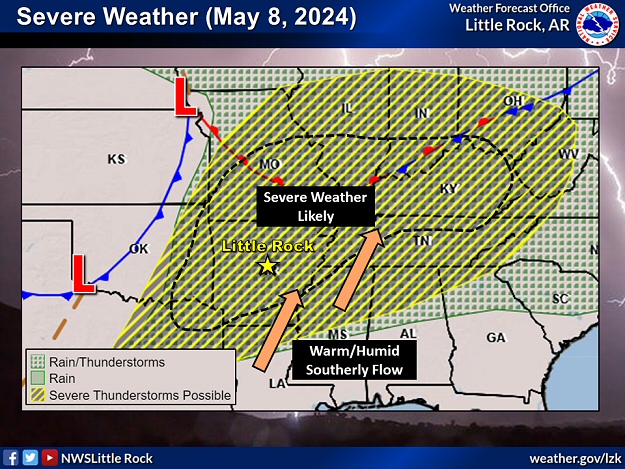
The tornado in Garland County was a prelude to what was supposed to be a significant severe weather day on the 8th. A stalled front to the north was about to barrel across the region, and plow through a very warm, humid, and unstable environment. It was a recipe for disaster.
Fortunately, there was a capping inversion (the temperature rose 10 degrees from 57F to 68F roughly 5,000 to 7,000 feet aloft), and storms struggled to develop and intensify. The inversion was realized during an early evening (700 pm CDT) balloon launch/sounding at the North Little Rock Airport (Pulaski County).
|
| Sounding at North Little Rock (Pulaski County) at 700 pm CDT on 05/08/2024 |
| Height (meters) |
Temperature (Deg C) |
| 173 |
26.8 |
| 466 |
24.0 |
| 969 |
20.4 |
| 1463 |
16.5 |
| 1606 |
14.0 |
| 1866 |
17.9 |
| 2005 |
20.0 |
| 2435 |
16.7 |
| 2978 |
11.6 |
| 3581 |
7.0 |
| Note: Temperatures dropped (from 26.8 deg C to 14.0 deg C) for the first 1,600 meters of the flight, and then rose (from 14.0 C to 20.0 C) for the next 400 meters (an inversion) before falling again. |
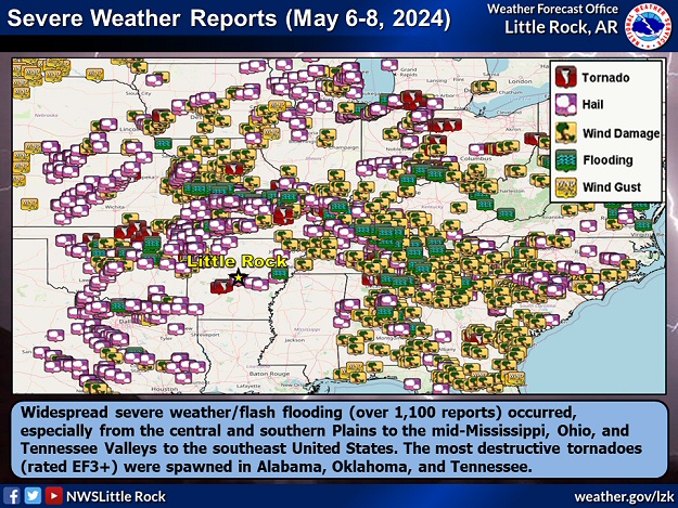 |
| In the picture: Widespread severe weather/flash flooding (over 1,100 reports) occurred in the three day (seventy two hour) period ending at 700 am CDT on 05/09/2024, especially from the central and southern Plains to the mid-Mississippi, Ohio, and Tennessee Valleys to the southeast United States. The most destructive tornadoes (rated EF3+) were spawned in Alabama, Oklahoma, and Tennessee. |
|
| |
|
A few storms managed to produce large hail, with quarter size stones reported at Dodd City (Marion County) and Fayetteville (Washington County). At Salem (Fulton County), 50 to 60 mph wind gusts were estimated, and trees were toppled near Marmaduke (Greene County).
It was a far different story from central Tennessee into northern Alabama. Capping was minimal and storms thrived. At least three monster tornadoes (rated EF3) carved paths through Columbia, TN, Athens, AL, and Henagar, AL. Miraculously, there was only one fatality.
|
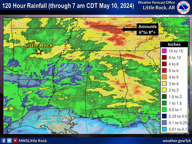 |
| In the picture: Five day (one hundred twenty hour) rainfall through 700 am CDT on 05/10/2024. |
|
| |
|
In addition to the tornadoes, more than a half foot of rain dumped in areas just north/east of Nashville, TN. Water flowed into homes, and roads were flooded and impassible in some cases. Since the 5th, two to more than three inches of rain fell in northwest, central, and east central Arkansas. Toward the Louisiana border, less than a quarter inch of rain was measured due to too much capping/a lack of storms.
|
|
|
| In the video: Mammatus clouds covered the sky over northwest Arkansas during the evening of 05/08/2024. The video is courtesy of Brian Emfinger via X (formally Twitter). |
|
| |
|
As the event came to a close, folks in northwest Arkansas were treated to a spectacular view of mammatus clouds. While the clouds were a sign that a noteworthy severe weather episode just unfolded, they were also a reminder what we endured could have been far worse.
|
|
|

