|
| Storm Reports |
| Are you interested in what happened during a recent event? Check out the report below. |
|
|
 |
Severe Storms on May 21-26, 2024 |
 |
| |
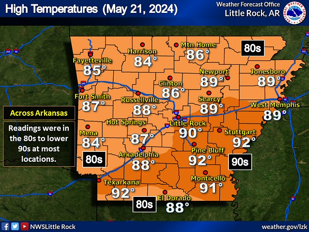 |
| In the picture: High temperatures were in the 80s to lower 90s on 05/21/2024 (well above normal highs in the upper 70s to mid 80s). |
|
| |
| Heading into late May, there was a lot to be concerned about in Arkansas. Several potent storm systems were set to traverse the middle of the country. Fronts pushed into the state from the Plains, and then waffled back to the north after the systems exited to the east. The fronts encountered well above average temperatures at times, and moisture levels were almost tropical. Scattered to numerous severe storms were in the forecast. |
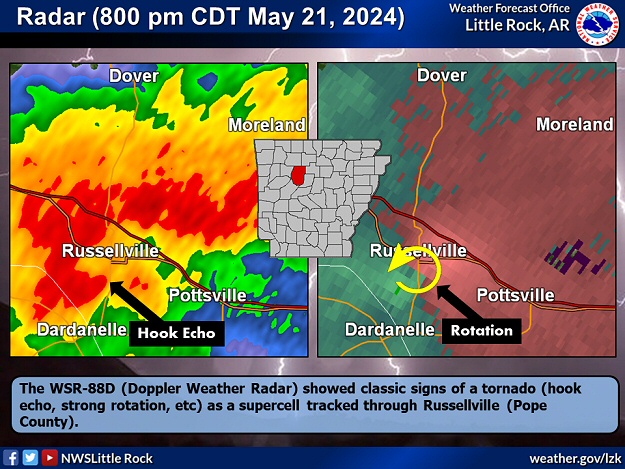 |
| In the picture: The WSR-88D (Doppler Weather Radar) showed classic signs of a tornado (hook echo, strong rotation, etc) as a supercell tracked through Russellville (Pope County) during the evening of 05/21/2024. |
|
| |
|
During the evening of the 21st, there were supercells (storms with rotating updrafts) along the Arkansas River west of Little Rock (Pulaski County). Several Tornado Warnings were issued, and signs were ominous (on radar) that a tornado was spawned at Russellville (Pope County). While a funnel cloud was witnessed, it did not reach the ground. There were power lines downed on the south side of town (due to damaging straight-line winds). Farther east, a tree was blown onto a house in Greenbrier (Faulkner County).
|
|
|
| In the video: A severe thunderstorm produced damaging straight-line wind and hail at Jonesboro (Craighead County) on 05/22/2024. The video is courtesy of Matt Conatser via X (formally Twitter). |
|
| |
|
On the 22nd, the focus shifted mainly to the northeast counties. The storm of the day rocked Jonesboro (Craighead County) with up to golf ball size hail and unleashed a 70 mph wind gust at the airport. Numerous trees were toppled and homes/businesses sustained minor wind damage. Elsewhere, quarter size hail was reported at Fair Oaks (Cross County), Harrisburg (Poinsett County), Marianna (Lee County), and Whelen Springs (Clark County). Trees were uprooted at Caraway (Craighead County) and near Watkins Corner (Phillips County), and power poles were pushed over between Osceola and Blytheville (both in Mississippi County) along U.S. Highway 61. East of Blevins (Hempstead County), nineteen head of cattle were killed by lightning while standing under a tree. Torrential rain flooded roads in Harrisburg (Poinsett County) and Wynne (Cross County).
Early on the 23rd, a downpour and more than five inches of rain washed out a ten foot section of a county road around New Hope (Hempstead County). Residents in the area were unable to leave or access their homes.
|
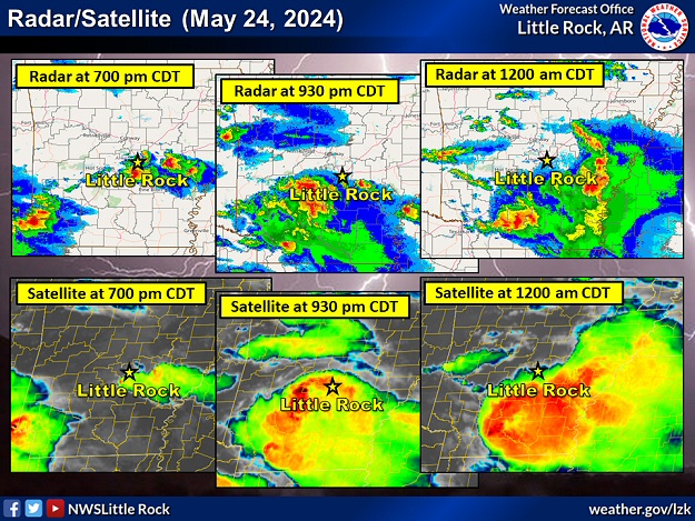 |
| In the picture: The WSR-88D (Doppler Weather Radar) and satellite showed scattered severe storms east of Little Rock (Pulaski County) early in the evening, with a cluster of strong to severe storms to the southwest. Over time (through midnight CDT), the cluster moved into central and east central sections of the state, and was responsible for widespread hail and wind damage. |
|
| |
|
Activity picked up a lot on the 24th. During the predawn hours, a weak tornado (rated EF1) touched down between De Queen and Lockesburg (both in Sevier County), and was on the ground for eight miles. Mostly tree damage was noted, although outbuildings and sheds were roughed up. The late afternoon/evening began with softball size hail at Slovak (Prairie County) and golf balls at Lexa (Phillips County). There was also a 63 mph wind gust at the Stuttgart Municipal Airport at Fairmount (Prairie County), and a 61 mph gust south of at McCreanor (Lonoke County). That was followed by a cluster of severe storms that marched from southwest through central and east central Arkansas. Trees were mowed down from Blevins (Hempstead County) and Kirby (Pike County) to Benton (Saline County), Little Rock (Pulaski County), Sheridan (Grant County), and Pine Bluff (Jefferson County). Quarter to hen egg size hail occurred in places. A 64 mph gust was measured at Maumelle (Pulaski County), with 50 to 55 mph gusts at airports in Camden (Ouachita County) and Pine Bluff (Jefferson County).
|
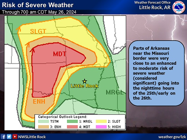 |
| In the picture: Parts of Arkansas near the Missouri border were very close to an enhanced to moderate risk of severe weather (considered significant) going into the nighttime hours of 05/25/2024 and early the next morning. |
|
| |
|
If you thought the 24th was bad, conditions were horrific before dawn on the 26th. The environment looked ominous (warm/humid with lots of shear to promote rotation in developing storms) from the central and southern Plains to southern Missouri and extreme northern Arkansas.
|
|
|
| Radar | Satellite |
| In the videos: The WSR-88D (Doppler Weather Radar) showed a supercell (storm with rotating updrafts) that spawned multiple tornadoes (some deadly) in extreme northern Arkansas during the predawn hours of 05/26/2024. A second storm followed closely behind, and produced additional significant severe weather. Satellite showed the supercell tracking across north central and northeast Oklahoma the previous evening, with the second storm originating in southeast Kansas. The radar video is courtesy of Todd Yakoubian via X (formally Twitter). The satellite video is courtesy of CIMSS (Cooperative Institute for Meteorological Satellite Studies). |
|
| |
|
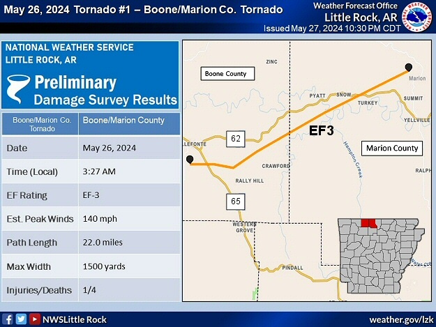
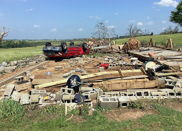
Fifteen tornadoes cut swaths from Benton County eastward through Madison, Boone, Marion, Baxter, Fulton, Sharp, and Randolph Counties. Most of these were weak (rated EF0/EF1) and did not last long. However, survey teams confirmed at least EF3 damage and longer track tornadoes through Briarcliff (Baxter County), west of Decatur (Benton County), and Olvey (Boone County). There was some EF2 damage south of Decatur, west of Centerton, and at Rogers (all in Benton County), as well as north/west of Salesville (Baxter County).
|
|
|
| |
|
Houses/mobile homes and businesses were heavily damaged or destroyed, and at least ten fatalities were counted (5 in Benton County, 2 in Boone County, 2 in Marion County, and 1 in Baxter County).
|
|
Half of the casualties were directly related to tornadoes (in Boone, Marion, and Baxter Counties). Another death was the result of straight-line winds up to 90 mph leveling a tree onto a manufactured home at Monte Ne (Benton County). A woman at Rogers (Benton County) passed away after her CPAP machine (providing oxygen) stopped running due to the loss of electricity. A lineman overheated while trying to restore utilities near Decatur (Benton County) and suffered a heart attack. Finally, two people drowned in a swollen Sugar Creek near Bella Vista (Benton County).
|
|
|
| |
|
This was the deadliest event in the state in ten years (since the Mayflower/Vilonia Tornado of April 27, 2014 that claimed 16 lives). Up to tennis ball size hail pelted Omaha (Boone County) and Rogers (Benton County). Power was knocked out to at least 125,000 utility customers.
|
| The Origin of the Deadly Storm |
|
The life of the parent supercell that caused most of the significant damage early on May 26th can be traced back to near Canton, OK (225 miles west of Arkansas) around 730 pm CDT on the 25th. Not far from town, a cluster of storms popped up and headed toward us. One of the storms became dominant/rapidly strengthened east of Enid, OK around 900 pm CDT. The storm arrived in northwest Arkansas four hours later.
|
|
|
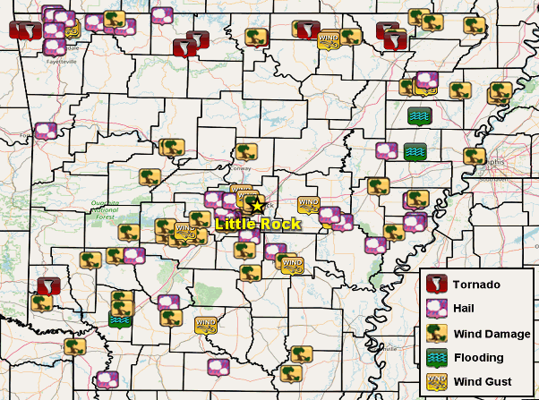
| In the picture: Five day severe weather and flash flood reports through 700 am CDT on 05/26/2024. |
|
| |
|
Farther east, an 86 mph gust was recorded at an airport near Ash Flat (Sharp County). Many trees were uprooted/snapped (by estimated 90 to 100 mph gusts) and a mobile home was rolled between Ozark Acres and Williford (both in Sharp County). Fallen trees blocked roads around Pocahontas (Randolph County) and Corning (Clay County).
|
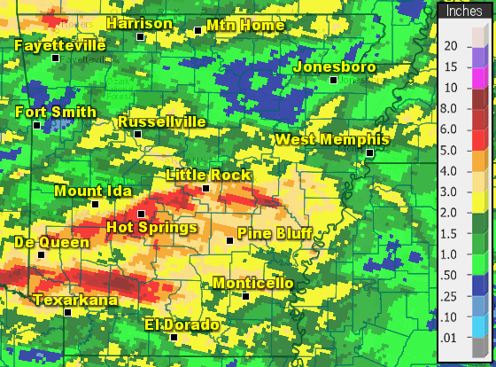 |
| In the picture: Seven day rainfall through 700 am CDT on 05/26/2024. |
|
| |
|
Through the morning of the 26th, the most precipitation dumped in central and southern Arkansas. Two to more than four inches was common since the event began (on the 21st). Across the north, while more than two inches of rain fell in spots, some locations received less than half inch amounts.
The event ended with a passing cold front and one more round of severe storms during the afternoon/evening of the 26th. Ahead of the front, heat index values peaked between 100 and 105 degrees in the southern half of the state. A house was torn up at Paragould (Greene County), and the culprit was a tornado (rated EF2). Another brief weak tornado (rated EF1) was identified about six miles north of Lester (Craighead County). There was golf ball size hail north of Denver (Carroll County), and ping pong ball size stones southwest of Grandview (Carroll County), Paragould (Greene County), and Success (Clay County). A 58 mph wind gust was clocked west of Patterson (Woodruff County), and a power pole was splintered at Bald Knob (White County).
|
| Record Outbreak of Tornadoes? |
|
The 17 tornadoes tallied on May 26th (15 early in the day and 2 in the evening) were the most in a day since April 25, 2011 (18 tornadoes). The tornado (rated EF3) west of Decatur (Benton County) had a path width of 3200 yards, which is a state record (since 1950). There were 10 fatalities which is the most since April 27, 2014 (16 deaths).
|
|
|