A storm system brought isolated to scattered severe storms to areas west and north of the state from the first into the second day of the month. Two EF1 tornadoes occurred in Benton County early on the 2nd with a few other severe weather reports noted across the state, but elsewhere across the state no severe weather occurred. Numerous reports of severe weather were received across areas from Missouri into the Ohio Valley from Apr 1-2 where several tornadoes occurred.
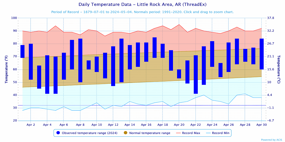
In the wake of this, a strong storm system provided cooler temperatures and breezy NW winds from April 2-4. Non-thunderstorm wind gusts exceeded 30-40 mph at times. Overnight lows dipped down into the 30s and 40s the morning of the 4th and 5th with a freeze observed in a handful of locations across northern and western Arkansas.
Leading up to the anticipated total solar eclipse, fairly quiet weather conditions were noted across the state. A cold front which acted more like a dryline moved across the state on April 7th. A few showers developed across western AR ahead of it during the morning hours with isolated thunderstorms developing ahead of it during the afternoon/evening hours along the MS River. A few storms became severe, with most of the reports occurring in Tennessee. Behind the front, winds were gusty and very dry air filtered in. Afternoon min relative humidity bottomed out in the teens across western and northern Arkansas.
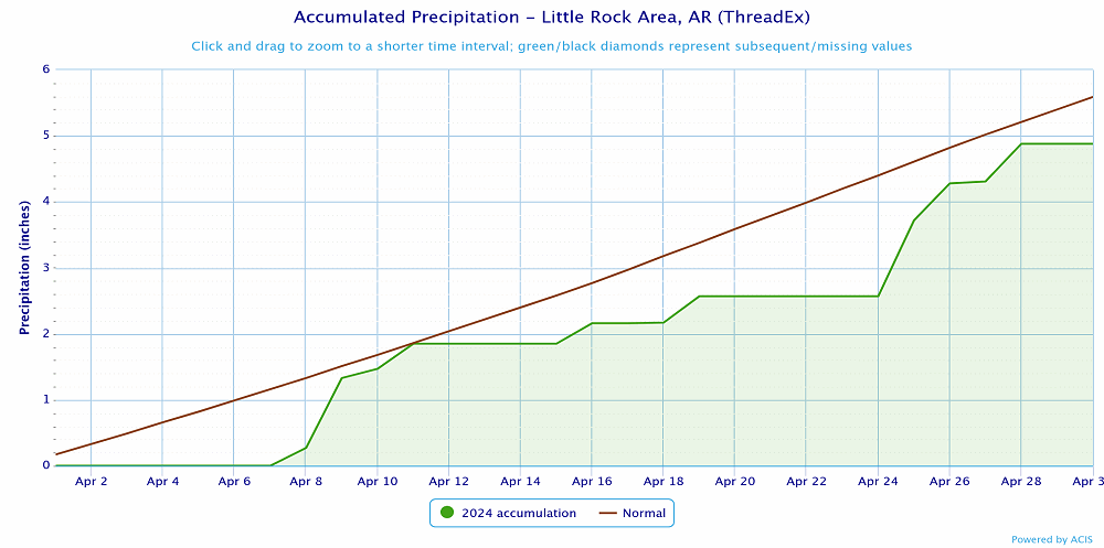
On the day of the eclipse (April 8th) clear sky conditions lasted long enough for good eclipse viewing along much of the path of totality across Arkansas but cloud cover and storms lifted north across the state by the evening and overnight hours of the 8th. Rain and thunderstorms moved across the state through the early morning hours of the 11th, before it was all said and done. The southern half of the state picked up the most rain with areas near the MS/LA border picking up the highest totals. In the wake of the rain, windy and dry conditions were noted on the 11th.
Calm, dry weather was seen through the 14th with a storm system approaching from the west. Southerly winds and moisture increased from April 14-15.
Scattered showers and thunderstorms occurred across parts of the state on the 16th with a few of these storms producing large hail in central Arkansas. Much warmer temperatures were seen through the 18th with a cold front set to move across the area from the evening of the 18th through the morning hours of the 19th. Before the front arrived a complex of thunderstorms moved across portions of southeast Arkansas and dumped some very heavy rainfall. Some locally heavy downpours occurred with storms ahead of the front (widespread rainfall remained difficult to come by), and severe weather remained scarce across Arkansas. Severe weather was more abundant to the north and east. Behind the front, much cooler temperatures were observed.
Some rain was observed, mainly across southern Arkansas from April 20-21 with below normal temperatures noted. The coolest morning was observed on the 22nd when temperatures fell into the 30s across parts of the state. Several locations across northern and western parts of the state recorded another freeze, but temperatures only remained at or below freezing for a short period of time.
Quiet weather was noted for a few days with warming temperatures. A busy period of weather began on the 25th when an area of rain and thunderstorms moved from western to central Arkansas during the morning hours. Very heavy rainfall occurred along portions of I-40 with some of the storms producing hail and damaging winds.
A second wave of thunderstorms occurred on the 26th. Some storms occurred across W/NW Arkansas during the morning hours with little in the way of severe weather reported. More widespread severe weather occurred during the evening hours from Texarkana into central and eastern parts of the state as a few storms merged and formed into a line across these areas. A few hail reports below 1” were received, but several wind damage reports were noted along I-30 into central Arkansas and then E/NE from there toward Augusta.
Compared to portions of Iowa and Nebraska, April 26th was a fairly quiet weather day locally across Arkansas as residents of those states dealt with a tornado outbreak.
A lull in activity was seen for most areas on the 27th with more storms occurring across Oklahoma and Kansas. Many folks across Arkansas took some time on the 27th to reflect on the lives lost and homes destroyed by the long track EF4 tornado that occurred on April 27, 2014.
A weakening complex of thunderstorms progressed eastward across much of the state during the morning into the afternoon hours of the 28th. With rain and associated cloud cover in place through much of the day, the overall severe weather threat was tempered. A few supercells developed and moved NE across portions of W/NW Arkansas during the evening hours. A tornado occurred in Carroll County. To the south, a line of thunderstorms developed across northern LA and southern AR and moved east across the southern third of the state during the evening hours. Some wind damage occurred across parts of southern Arkansas.
Before the cold front moved across the state by the evening of the 29th, some isolated to scattered showers and thunderstorms occurred. A few storms produced hail across central and W/SW Arkansas, but little in the way of any severe weather occurred. Dry and warm conditions ended the month on the 30th after a foggy morning.