 |
| Storm Reports |
| Are you interested in what happened during a recent event? Check out the report below. |
|
|
 |
Severe Storms/Heavy Rain on April 26-29, 2024 |
 |
| |
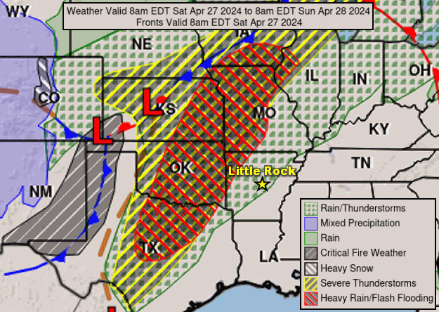 |
| In the picture: The forecast map on 04/27/2024 showed a cold front in the Plains, with widespread severe weather and flash flooding expected from Iowa to Texas. |
|
| |
|
Heading into late April, the severe weather season was almost non-existent in Arkansas. Only four tornadoes were counted across the state. By contrast, there were dozens of tornadoes in the Ohio Valley to start 2024. Oddly, California and West Virginia had more tornadoes than Arkansas. On the 26th through the 28th, the focus for tornadoes shifted to the Plains and upper Midwest, and there was some chance of tornadoes locally.
|
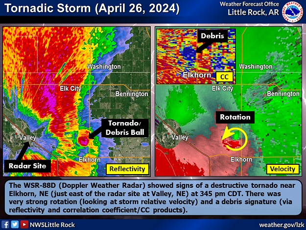 |
| In the picture: The WSR-88D (Doppler Weather Radar) showed signs of a destructive tornado near Elkhorn, NE (just east of the radar site at Valley, NE) at 345 pm CDT on 04/26/2024. There was very strong rotation (looking at storm relative velocity) and a debris signature (via reflectivity and correlation coefficient/CC products). |
|
| |
|
On the 26th, there was a tornado outbreak mainly in Nebraska and Iowa. Destructive tornadoes (that leveled structures) were spawned on the north/west side of Omaha, NE and Harlan, IA (both rated EF3).
|
 |
| In the picture: Severe weather reports on April 26-28, 2024. |
|
| |
|
In Arkansas, a cluster of severe storms raced from southwest through central into northeast sections of the state in the late afternoon/evening. The storms followed Interstate 30 and U.S. Highway 67/167 from Hope (Hempstead County) to Little Rock (Pulaski County) and Weldon (Jackson County). While there were no tornadoes, there were 60 to 80 mph straight-line wind gusts in places, and trees, power lines, and billboards downed. At Beebe (White County), some trees were on houses.
|
|
|
| In the video: A massive wedge tornado (EF3) affected areas from Minden, IA to Defiance, IA (including Harlan, IA) during the late afternoon/early evening of 04/26/2024. The video is courtesy of Scott Hollinger via X (formally Twitter). |
|
| |
|
More monster tornadoes cut through portions of Kansas, Oklahoma, and Texas on the 27th. The tornadoes (rated EF3 or higher) were deadly in Holdenville, OK, Marietta, OK, and Sulphur, OK (at least four fatalities).
|
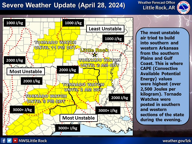 |
| In the picture: Widespread clouds and showers/thunderstorms cooled and stabilized the atmosphere in much of Arkansas during the morning/early afternoon of 04/28/2024. Toward evening, more unstable air tried to build into the state from the south/west. Tornado Watches were posted in the southern/western counties as a result. |
|
| |
|
The 28th started with a lot of clouds and rain in Arkansas, and this tended to stabilize the atmosphere. This limited the severe weather potential later in the day (even through some warming eventually took place). Scattered supercells (storms with rotating updrafts) developed in eastern Oklahoma and northwest Arkansas, mostly after dark. It appears one storm produced a tornado between Osage and Carrollton (both in Carroll County). The tornado (rated EFU where "U" is unknown) was illuminated by lightning and captured on a media tower camera at Gaither Mountain (Boone County).
|
|
|
| In the video: Simulated radar showed scattered strong/severe thunderstorms in northwest Arkansas, with a line of storms in the south during the evening of 04/28/2024. Elsewhere, storms struggled to develop/intensify due to a more stable atmosphere. The data is courtesy of the College of DuPage. |
|
| |
|
Meanwhile, a bowing (backward C-shaped) line of storms arrived in areas south of Little Rock (Pulaski County) from eastern Texas/northwest Louisiana. These storms posed a risk of wind damage/isolated tornadoes. Trees were toppled near Fouke (Miller County), Bradley (Lafayette County), and southwest of Taylor (Lafayette County). Two tornadoes (both rated EF1) were identified in southern Lafayette County. Other than causing tree damage, power poles were snapped, and a metal barn was dismantled.
A cold front pushed through the region from the northwest on the 29th. Ahead of the front, isolated storms produced nickel to quarter size hail north of Hartman (Johnson County) and west of Plumerville (Conway County).
|
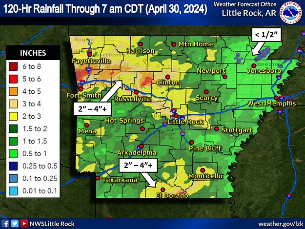 |
| In the picture: Five day (one hundred twenty hour) rainfall through 700 am CDT on 04/30/2024. |
|
| |
|
There were areas of heavy rain during this event. Two to more than four inch totals were noted from central into northwest Arkansas (in the Ozark Mountains and Arkansas River Valley), and also in the far south. Less than a half inch of precipitation was measured in parts of the northeast.
|
|
|

