 |
| Storm Reports |
| Are you interested in what happened during a recent event? Check out the report below. |
|
|
 |
Heavy Rain/Spotty Severe Storms on April 8-11, 2024 |
 |
| |
 |
| In the picture: Leading up to the eclipse on 04/08/2024, the large scale pattern featured a south/southwest flow into Arkansas. This eventually pumped a lot of moisture into the region, and rain became widespread. Preceding the rain, a cold front brought a brief period of dryness, and made eclipse viewing possible. |
|
| |
|
The biggest news by far in April was a rare total solar eclipse in Arkansas (the first since 1918 across the state) on the 8th. Leading up to the event, it was understood that viewing such an eclipse was iffy given a very changeable weather pattern this time of year.
|
|
|
| In the video: The view of the eclipse was spectacular at Hardy (Sharp County) on 04/08/2024. The video is courtesy of Charles Peek via X (formally Twitter). |
|
| |
|
Fortunately, a well timed cold front and drier air gave local residents and scores of visitors a small window of opportunity to catch a glimpse of the moon completely blocking the sun in the early afternoon.
|
|
|
| In the video: There was a medium to high chance of viewing the eclipse along the path of totality in Arkansas on 04/08/2024. Not long after the eclipse, clouds thickened rapidly, and the weather became unsettled. |
|
| |
|
This spectacle was breathtaking but fleeting, with clouds rapidly thickening during the late afternoon and evening hours. A storm system was on the way from the southwest United States, and showers and thunderstorms became widespread.
|
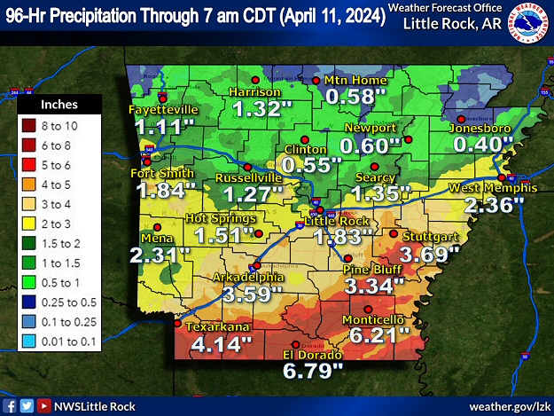 |
| In the picture: Four day (ninety six hour) rainfall through 700 am CDT on 04/11/2024. |
|
| |
|
This was mainly a heavy rain episode through the early morning of the 11th. Precipitation amounts exceeded six inches toward the Louisiana border, with totals over two inches common in the southern half of the state. Across the northern counties, many locations received less than an inch of rain. Because cloudbursts were spread out over several days (instead of all at once), flash flooding was localized. Minor flooding was noted along the Ouachita River.
|
|
|
| In the video: While the radar showed brief rotation south of Scott (Pulaski County) during the evening of 04/08/2024, a microburst (not a tornado) was responsible for damage in the area. |
|
| |
|
While there was not much severe weather, some damage was reported south of Scott (Pulaski County) shortly after 830 pm CDT on the 8th. Trees were uprooted, outbuildings were tossed, and roofing/siding material was blown off of several homes. Power was also knocked out. Thunderstorm straight-line wind (a microburst) up to 90 mph was responsible for the havoc. Elsewhere, a roof was removed from a home just northwest of LaGrange (Lee County), and baseball size hail occurred at Alpine (Clark County). Quarter size hail was produced southwest of Sardis (Saline County) and near Texarkana (Miller County).
|
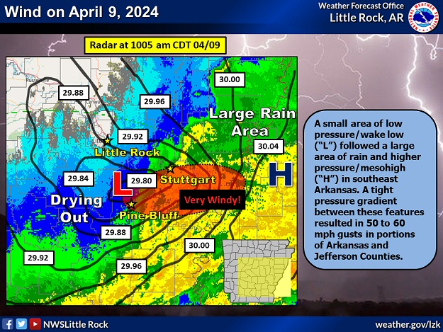 |
| In the picture: A small area of low pressure/wake low ("L") followed a large area of rain and higher pressure/mesohigh ("H") in southeast Arkansas as of 1005 am CDT on 04/09/2024. A tight pressure gradient between these features resulted in 50 to 60 mph gusts in portions of Arkansas and Jefferson Counties. |
|
| |
|
On the 9th, a large area of rain was on the way out of southern Arkansas. On the heels of the downpours, drying/warming led to rapidly falling pressure/the formation of a wake low and windy conditions. Wind gusts reached 50 to 60 mph in portions of Arkansas and Jefferson Counties. Trees were toppled, with one tree on a mobile home at Stuttgart (Arkansas County). There was a minor injury reported.
|
 |
| In the picture: The vast majority of severe weather/flash flood reports on April 9-10, 2024 were south of Arkansas from Texas to Georgia and Florida. |
|
| |
|
Severe storms were much more prolific to the south of the state on the 9th/10th. There were numerous reports of large hail, damaging winds/wind gusts, and tornadoes from Texas to Georgia and Florida. A deluge resulted in ten to fifteen inches of rain in spots, and many instances of flash flooding.
|
|
|

