 |
| Yearly Reports |
| Interested in what kind of weather occurred in a recent year? Check out the most memorable events below. |
|
|
 |
Arkansas Yearly Climate Summary (2023)/Pg3 |
 |
| |
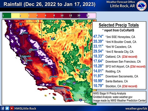 |
| In the pictures: Rainfall across California in a three week period ending on 01/17/2023. |
|
| |
|
Outside of Arkansas, there was a deluge in California in January. This was a switch given years of drought locally. In a three week period ending on the 17th, a statewide average 11.47 inches of precipitation dumped. This was just over half (51%) of what should occur in an average year (22.39 inches)! There were several reports of three to four feet of rain, and fifteen or more feet of snow in the highest elevations of the Sierra Nevada Mountains. At San Francisco, CA (at the airport), 15.28 inches of rain fell, which was the highest twenty three day total on record locally. So much precipitation in a short time led to overflowing tributaries, flooding of homes and businesses and roads, mudslides, and sinkholes. At least twenty two fatalities were blamed on this extreme high water episode.
On the 25th, there were tornadoes along the Gulf Coast. A tornado (rated EF3) caused widespread structural damage on the southeast side of Houston, TX (at Deer Park, TX and Pasadena, TX). Vehicles and semi trucks were flipped by a tornado (rated EF2) along Interstate 10 near Orange, TX. Roofs were removed from homes by a tornado (rated EF2) from southeast of DeQuincy, LA to Gaytine, LA.
Meanwhile, it snowed at Central Park in New York City, NY on February 1st. It was not much, but 0.4 inch of flakes accumulated. This was the latest first measurable snow since data collection began in 1869. A couple of days later, bitterly cold air poured into New England. A staggering wind chill index of 108 degrees below zero was registered at Mount Washington, NH on February 3rd. It is believed this is the lowest wind chill on record in the country. Wind gusts topped 120 mph at times. On the 4th, the low temperature at Boston, MA was 10 below zero. Locally, this was the first double digit negative reading since 1957. Frostquakes (or cryoseisms) were reported in Maine as the frozen soil cracked suddenly and tremors were felt. Trees also split as sap rapidly froze and expanded.
|
|
| In the video: The Mud River overflowed its banks in mid-February, 2023, and caused extensive flooding at Milton, WV. The video is courtesy of the City of Milton, WV via Facebook. |
|
| |
|
Flooding rain spread from the Ohio and Tennessee Valleys to the central Gulf Coast on February 16th/17th. High water issues were the most impactful from West Virginia into eastern Kentucky. Fast currents swept vehicles off the road at Pax, WV and Bradfordsville, KY. Two people were killed. Students were stranded at school after the Mud River overflowed in Lincoln County, WV. The same river overtook homes in Milton, WV. A mudslide at Ragland, WV destroyed a home. Roads and schools were closed in Marion County, KY when the Rolling Fork River breached its banks.
|
|
|
| In the video: A tornado (rated EF4) obliterated much of Rolling Fork, MS during the evening of 03/24/2023. The scope of the damage was realized at first light the next morning. The video is courtesy of Aaron Rigsby via X (formally Twitter). |
|
| |
|
Around 800 pm CDT on March 24th, something horrible unfolded less than twenty miles away from the southeast corner of Arkansas. Just across the Mississippi River in western Mississippi, a discrete supercell (storm with rotating updrafts) spawned a monster tornado (rated EF4/170 mph peak wind) that cut an almost sixty mile swath through Rolling Fork, Silver City, and Tchula. Structures were steamrolled, trees were debarked, and vehicles were tossed. Sadly, the tornado was responsible for at least seventeen fatalities. Farther northeast, the same supercell cranked out a couple more tornadoes (both rated EF3/155 mph peak wind) that carved out twenty nine mile and thirty seven mile paths through Winona, Amory, and Smithville. Five people were killed (a total of twenty two deaths in Mississippi).
|
 |
| In the picture: The highest severe weather potential (a moderate to high risk) on 03/31/2023 existed where the most lift (from the central Plains toward the mid-Mississippi Valley) overlapped the most unstable air (from the Texas Gulf Coast toward the Tennessee Valley). This included parts of Arkansas. |
|
| |
|
March is supposed to go out like a lamb, but not in 2023. It wasn't even close. Instead, an outbreak of severe weather occurred from Iowa to Arkansas and areas farther east through the Ohio and Tennessee Valleys on the 31st. In addition to two high end tornadoes (rated EF3) that affected Little Rock (Pulaski County) and Wynne (Cross County), this event featured over a thousand reports of tornadoes, damaging wind, and large hail. There were at least eleven dozen tornadoes (including those tallied on April 1st), and a dozen of these were rated EF3 or higher.
The strongest tornado (rated EF4) was on the ground forty three miles from Ottumwa, IA to Iowa City, IA. The deadliest (nine casualties) tornado (rated EF3) had an eighty six mile path from south of Hornsby, TN to east of Hohenwald, TN. Six people were killed by a tornado (rated EF3) that went from Sainte Marie, IL to Sullivan, IN (forty one miles). On April 1st, a rare EF3 tornado was documented in southern Delaware. It tied for the strongest tornado in state history (with a similarly rated tornado in April, 1961).
Around 330 am CDT on April 5th, a deadly tornado (rated EF2) ravaged Glenallen, MO. Mobile homes were destroyed and houses were dismantled. Numerous trees were snapped near the ground. Tragically, five fatalities were counted.
|
|
|
| In the picture: A Flash Flood Emergency was issued for the Fort Lauderdale, FL area on 04/12/2023 by the National Weather Service in Miami, FL. |
|
| |
|
A ridiculous 25.91 inches of rain came down at Fort Lauderdale, FL on April 12th, shattering the previous one day record of 14.59 inches (on April 25, 1979). There was water everywhere, and it shut down the airport, turned roads into lakes, stranded hundreds of vehicles, and sent dozens of homeowners to shelters. Given a life threatening situation, the mayor declared a state of emergency. In November, the yearly precipitation total eclipsed 100 inches (40 inches above average) for only the second time since data collecting began locally (in 1912).
|
|
|
| In the picture: From the Rockies eastward, there were hundreds of reports of severe weather on June 11-16, 2023. The graphic is courtesy of the Storm Prediction Center. |
|
| |
|
Significant severe weather was not confined to Arkansas on June 11th through the 16th. From eastern Colorado and west Texas to parts of the mid-South, large hail and isolated tornadoes were the main features (along with damaging wind in places). Across the southeast states, there was more wind and less hail, along with tornadoes here and there. The strongest tornado (rated EF3) was at Perryton, TX on the 15th. The tornado damaged or destroyed homes, retail stores, and industrial buildings, and was blamed for three deaths. Other significant tornadoes (rated EF2) spun up (on the 14th/15th) in the Texas panhandle, eastern Texas, southern Oklahoma, northern Ohio, and southwest Georgia.
Around 1230 am CDT on the 18th, thunderstorms pounded Tulsa, OK with up to 100 mph gusts. Trees and power lines were downed all over the city, and power was knocked out to more than 200,000 utility customers. At least three weak tornadoes (all rated EF1) were confirmed north and east of the city.
Three days later (on the 21st), there was record heat in Texas. Del Rio, TX and San Angelo, TX had all-time record high temperatures of 115 degrees and 114 degrees respectively. At the latter site, the same reading was reached the day before.
On the 25th, a half dozen tornadoes hit southern Indiana and central Kentucky. Hail reached tennis ball to softball size, and damaging straight-line wind gusts topped 100 mph. One of the stronger tornadoes (rated EF2) caused a home to collapse just south of Windom, IN (one fatality).
|
|
|
| In the pictures: Smoke from Canadian wildfires created unhealthy air quality from the upper Midwest into the Great Lakes, Ohio and Tennessee Valleys, and New England in mid-July, 2023. The information is courtesy of the National Weather Service in Lincoln, IL via X (formally Twitter). |
|
| |
|
A big problem in the summer was smoke from hundreds of Canadian wildfires. The smoke poured into the upper Midwest, Great Lakes, Ohio and Tennessee Valleys, and New England in mid-July. While the air quality went downhill, it was not as unhealthy as what was experienced in June (thicker smoke). The highest Air Quality Index (on a scale from 0 or "good" to 500 or "hazardous") readings were between 100 and 200, which was well below values close to 400 along the East Coast in the previous month.
At Phoenix, AZ, the mercury reached at least 110 degrees on a record thirty one days straight ending on July 30th (crushing the previous high mark of eighteen days in June, 1974), and there was not a drop of rain. It was the hottest month on record for any city in the United States!
Due to clusters of severe thunderstorms on August 7th/early on the 8th, a jaw dropping 1,400 reports of wind damage along with isolated tornadoes were received from the eastern Great Lakes to the central Appalachians, Tennessee Valley, and mid-Atlantic states. That's more reports (in a twenty four hour period) than on any other day in 2023. This is very impressive given the time of year (not spring).
|
|
|
| In the video: A strong pressure gradient between high pressure to the north of Hawaii and Hurricane Dora (very low pressure) to the south created damaging wind gusts on Maui on 08/08/2023. Near the town of LÄhainÄ, brush fire flames were fanned (from northeast to southwest), and the blaze got out of control. The information is courtesy of the National Weather Service in Honolulu, HI via X (formally Twitter). |
|
| |
|
In Hawaii, it was an awful situation on the island of Maui on August 8th. This part of the world was sandwiched between high pressure to the north and Hurricane Dora to the south. Between these features, a strong pressure gradient existed, and winds ramped up. Gusts from 60 to 80 mph blew across a very dry landscape, and fanned a brush fire just outside the town of LÄhainÄ. The fire rapidly grew, and consumed more than 2,200 structures in town. At least 93 people lost their lives, making this the deadliest blaze in the United States since the Cloquet (Minnesota) Fire in 1918. Just four years ago (2019), the Camp Fire in northern California reduced the town of Paradise to ashes and killed 85 people.
Later in August, the remnants of Hurricane Hilary brought unprecedented downpours to the western states (a rare event). A year's worth of liquid was measured at Death Valley National Park (in southern California) on the 20th. The 2.20 inches of rain made it the wettest day on record at the site. State rainfall records due to a tropical system were set in Idaho, Montana, Nevada, and Oregon.
It felt like a furnace along the Gulf Coast on the 27th. All-time record high temperatures were tied at Houston, TX (109 degrees) and broken at New Orleans, LA (105 degrees).
|
 |
| In the picture: The forecast on 08/28/2023 called for Tropical Storm Idalia to become a major hurricane before reaching the Florida Gulf Coast less than forty eight hours later. |
|
| |
|
In the tropics, Hurricane Idalia made landfall near Keating Beach, FL during the morning of August 30th. This was a Category 3 storm (maximum sustained wind around 125 mph). A life threatening storm surge sent water inland and flooded up to 6,000 homes twenty to thirty miles north of Tampa, FL (Pasco County). Record storm surges were observed in spots such as Cedar Key, FL. At least half a million utility customers in Florida lost power.
Idalia remained a hurricane in southern Georgia before weakening to a tropical storm in the Carolinas. Along the path of the system, five to more than ten inches of rain fell. Flooding temporarily closed Highway 75 near Valdosta, GA. At Charleston, SC, a flow inland ahead of Idalia caused water to top a seawall protecting the city. It was the fifth highest water level on record, and this led to major coastal inundation in the downtown area. In nearby Goose Creek, SC, a tornado flipped a car onto another vehicle along U.S. Highway 52 (two people injured).
|
 |
| In the picture: The Mississippi River was at record low levels at Memphis, TN in October, 2022, and the same thing happened a year later. The data is courtesy of the United States Geological Survey (USGS). |
|
| |
|
Drought encompassed much of the middle of the country in September/October. This included a long stretch of the Mississippi River, which experienced record/near record low levels for the second year in a row. Dredging was ongoing to help widen/deepen the river channel and keep barge traffic moving. Meanwhile, low flow allowed salt water from the Gulf of America to make headway into the river. This threatened the fresh water supply in portions of Louisiana.
Drought was not an issue in New York, NY. On September 29th, a whopping 8.05 inches of rain was unleashed at Kennedy Airport. This was the highest total on record locally in September. Flooding was considerable (affecting homes, businesses, and schools), and it prompted a state of emergency. A medical center was evacuated. Highways and numerous roads were closed due to high water. Railway and subway services were suspended and flights were cancelled.
In late October, ten to fifteen inches of rain flooded roads and structures on the south side of the Dallas-Fort Worth, TX metroplex. People were rescued from high water in Forney, TX and Kaufman, TX. Two residents were killed when their vehicle was swept off the road. Three police officers were injured during rescue operations.
|
|
|
| In the video: The satellite showed Otis strengthening from a tropical storm to a Category 5 hurricane in only twelve hours late on 10/24/2023. The hurricane made landfall near Acapulco, MX early the next morning (around 125 am CDT) with sustained winds estimated around 165 mph. |
|
| |
|
Early on October 24th, there were doubts that Tropical Storm Otis would become a hurricane before making landfall along the Pacific Coast of Mexico. As the day progressed, Otis not only attained hurricane status, it grew into a Category 5 storm. Otis moved ashore near Acapulco, MX with sustained winds around 165 mph (satellite estimated)! The aftermath was tragic: substantial damage (likely in the billions of dollars), severed communications, a large scale search for food and water, looting, and a rising death toll.
|
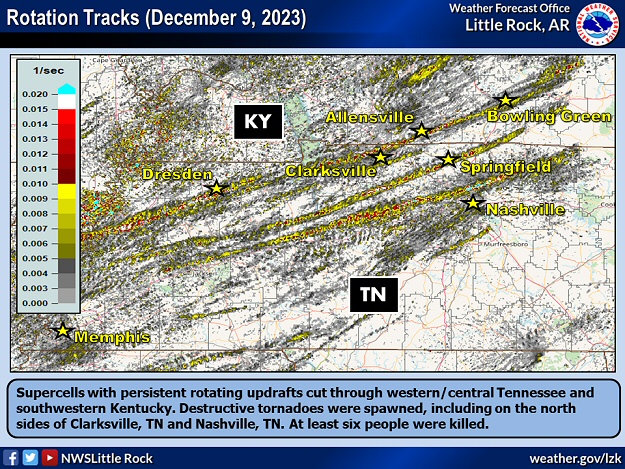 |
| In the picture: Supercells with persistent rotating updrafts cut through western/central Tennessee and southwestern Kentucky on 12/09/2023. Destructive tornadoes were spawned, including on the north sides of Clarksville, TN and Nashville, TN. At least six people were killed. |
|
| |
|
In early December (the 9th), supercells with persistent rotation developed mainly from western into central Tennessee and southwestern Kentucky. There were nine tornadoes in this part of the country, and five of these were rated EF2 or higher.
The strongest tornado (rated EF3) had a roughly forty three mile track, and ripped through the north side of Clarksville, TN. Another notable tornado (rated EF2) wreaked havoc just north of Nashville, TN (affecting Hendersonville, TN and Madison, TN). In all, there were six fatalities.
|
|
|


