Note: The yearly total of 30 tornadoes is below the thirty year average of 37 tornadoes. The latest tornado (rated EF1) tore through areas from Mansfield to Liberty (both in Sebastian County) early on July 14th. The strongest tornado (rated EF3/maximum winds around 165 mph) tracked almost 35 miles from 7 miles north-northwest of Alexander (Pulaski County) to 4 miles southeast of Austin (Lonoke County) on March 31st. There was one fatality (indirectly related to the tornado) and 54 injuries. The deadliest tornado (rated EF3/maximum winds around 150 mph) was on the ground 73 miles from 5 miles southeast of Fair Oaks (Cross County) to 2 miles southeast of Burlison (Tipton County, TN). The tornado was responsible for four deaths at Wynne (Cross County). There were also 26 injuries. Four tornadoes (in March, April, May, and June) were assigned ratings of EFU (unknown) because there was no damage to evaluate.
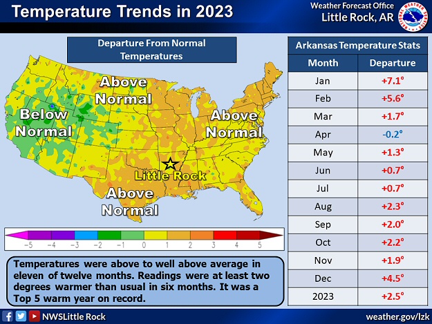
In the pictures: In 2023, above average temperatures (in red) and precipitation (in green) occurred in eleven and seven months respectively. Overall, it was warmer and wetter than normal.
As far as temperatures in 2023, readings were much warmer than average (a Top 5 warm year), especially during the first three months and in the late summer/fall. It was a Top 5 warm January/February (two month period), and a Top 10 warm August through December (five month period).
At individual sites (using data going back to the late 1800s), Little Rock (Pulaski County) had the warmest year on record, with Top 3 warm years at Fort Smith (Sebastian County), Pine Bluff (Jefferson County), and Texarkana (Miller County).
Warm and Wet Streak Continues
Temperatures and precipitation in Arkansas were above average for the ninth straight year. These are the longest such streaks in the state since records began in 1895.
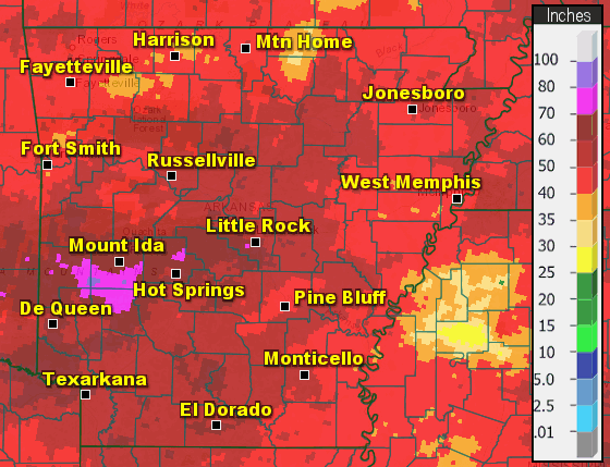
In the pictures: The wettest conditions in 2023 were found from central into west central (the Ouachita Mountains) and southwest Arkansas, with the driest areas in parts of the northwest (the Ozark Mountains) and southeast. Overall, it was a wetter than usual year by two to three inches. Note: Amounts in parts of the north (especially Fulton and Izard Counties) are underestimated.
The year started wet through the early spring, but it quickly dried out from the late summer onward. Precipitation was largely subpar from August through December. It was a Top 30 dry last five months of 2023, and a Top 15 dry November/December (two month period). This is when drought became an issue mostly from central into southeast Arkansas.
Precipitation in 2023
Site
Amount
Normal
+/-
% of Normal
Fayetteville (NW AR)
44.89
46.96
-2.07
96%
Harrison (NC AR)
44.59
44.50
+0.09
100%
Jonesboro (NE AR)
48.43
48.51
-0.08
100%
Fort Smith (WC AR)
45.29
47.34
-2.05
96%
Little Rock (C AR)
56.86
50.42
+6.44
113%
West Memphis (EC AR)
46.99
50.40
-3.41
93%
Texarkana (SW AR)
56.66
48.87
+7.79
116%
El Dorado (SC AR)
57.11
52.12
+4.99
110%
Pine Bluff (SE AR)
48.39
50.81
-2.42
95%
Note: The statewide average precipitation was 52.42 inches, or 2.81 inches above average. This was the 44th wettest year on record.
Average Temperatures in 2023
Site
Avg Temp
+/-
Fayetteville (NW AR)
60.8°
+3.4°
Harrison (NC AR)
60.0°
+1.7°
Jonesboro (NE AR)
62.9°
+2.8°
Fort Smith (WC AR)
64.8°
+2.4°
Little Rock (C AR)
66.2°
+4.5°
West Memphis (EC AR)
63.1°
+0.5°
Texarkana (SW AR)
68.0°
+4.0°
El Dorado (SC AR)
65.4°
+1.2°
Pine Bluff (SE AR)
66.7°
+3.7°
Note: The statewide average temperature was 62.9 degrees, or 2.5 degree above average. This was the 4th warmest year on record.
The following are some of the larger/most impactful events of 2023, and were mentioned in previous writeups on this website throughout the year.
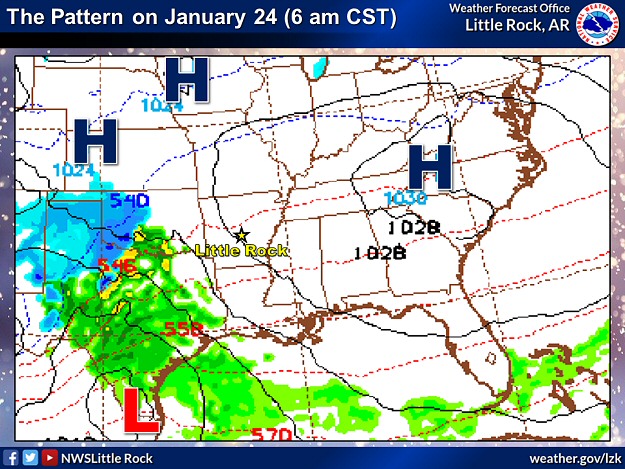
In the pictures: This forecast model showed a storm system ("L") tracking from southern Texas to western Kentucky in the twenty four hour period ending at 600 am CST on 01/25/2023. The system spread snow across northern and western Arkansas, and triggered severe thunderstorms along the Gulf Coast.
Following a blast of Arctic air on December 22nd (2022), winter was largely absent through the first three weeks of January. In fact, severe weather was more of a concern, with tornadoes spawned on the 2nd and 18th (in central/southern sections of the state). There were signs the pattern would change on the 24th/25th, and it would get cold enough to support heavy snow in the north and west.
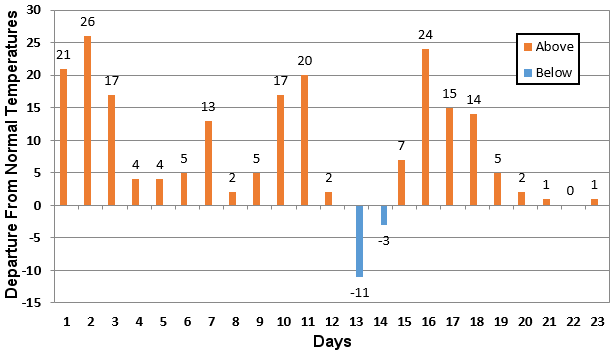
In the picture: Prior to the snow, temperatures in January, 2023 (through the 23rd) were largely above to well above average at Harrison (Boone County).
Up to this point, temperatures were eight to twelve degrees above average. Frozen precipitation seemed impossible, but some forecast models indicated more than a foot of snow in portions of northern Arkansas.
As confidence in a big snow episode increased, Winter Storm Warnings were posted in the Ozark and Ouachita Mountains. Snow was expected to begin by the early afternoon of the 24th.
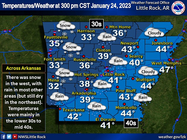
In the picture: Snow was falling in western Arkansas, with rain in most other parts of the state at 300 pm CST on 01/24/2023. Temperatures were mainly in the lower 30s to mid 40s.
By 300 pm CST, snowflakes were flying from Mena (Polk County) and Mount Ida (Montgomery County) to Fayetteville (Washington County) and Harrison (Boone County). Temperatures in these spots were in the lower to mid 30s. Farther south/east, it was too warm for snow, with rain occurring at most reporting stations.
In the video: Snow covered Highway 71 near Y City (Scott County) at 230 pm CST on 01/24/2023. The video is courtesy of the Arkansas Department of Transportation.
The first noticeable problems on roads were in the Ouachita Mountains (Polk and Scott Counties). While a warm ground prevented much accumulation initially, snow came down fast enough to collect on the pavement and cause accidents. As the afternoon and evening progressed, many roads north and west of Little Rock (Pulaski County) were snow/slush covered and hazardous.
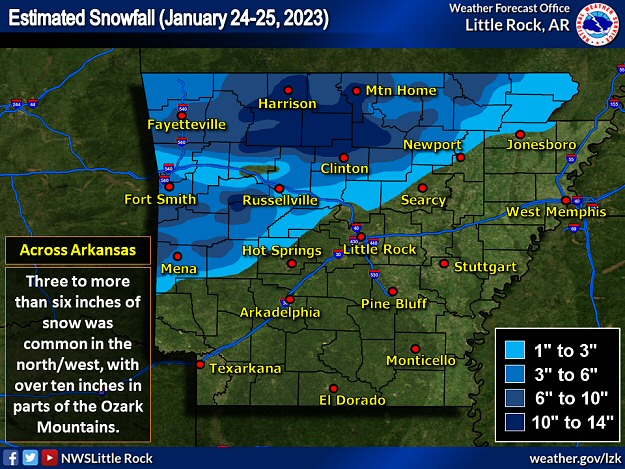
In the picture: Three to more than six inch snow accumulations were common in northern and western Arkansas on January 24-25, 2023. Parts of the Ozark Mountains received over ten inches of snow.
By the morning of the 25th, Mount Magazine (Logan County) had 16 inches of snow, with 14.5 inches southeast of Kay (Searcy County), 13 inches southeast of Jasper (Newton County) and at Witts Springs (Searcy County), 12.5 inches at Compton (Newton County), 12 inches at Bruno (Marion County) and Chimes (Van Buren County), 11.5 inches at Deer (Newton County) and Leslie (Searcy County), and 11 inches at Batson (Johnson County), Big Flat (Baxter County), Diamond City (Boone County), Dodd City (Marion County), and Pindall (Searcy County).
Elsewhere, three to more than six inch totals were common across much of northern and western Arkansas. Across the southern/central/eastern counties, while there were sleet pellets and snowflakes in places, rain was the main precipitation type.
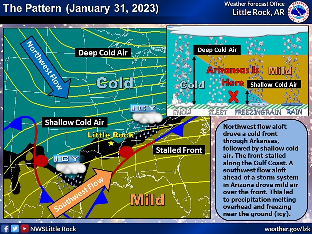
In the pictures: Northwest flow aloft drove a cold front through Arkansas on 01/29/2023, followed by shallow cold air. The front stalled along the Gulf Coast the new few days. A southwest flow aloft ahead of a storm system in Arizona drove mild air over the front. This led to precipitation melting overhead and freezing near the ground (icy). A sounding (temperature, dewpoint, and wind profile with height) at North Little Rock (Pulaski County) at 600 pm CST on 01/31/2023 showed the setup beautifully, with snow falling through a melting layer and becoming freezing rain and sleet.
Less than a week after the north/west were buried in snow, we were in for an icy mess to finish January. Shallow cold air followed a cold front through the state on the 29th, and then the front stalled along the Gulf Coast. An approaching storm system from the southwest United States drove mild air over the front into subfreezing conditions in Arkansas. While it snowed overhead, it melted and then refroze near the ground. The result was sleet and freezing rain.
In the video: Heavy sleet/light freezing rain caused travel problems in northwest Arkansas on 01/30/2023. The video is courtesy of Brian Emfinger via X (formally Twitter).
One to two inches of sleet piled up near Bella Vista (Benton County) Dublin (Logan County), Greers Ferry (Cleburne County), just north of Mountain Home (Baxter County), Piggott (Clay County), Pocahontas (Randolph County), and Rogers (Benton County). Otherwise, there were quite a few locations in the northern two to three rows of counties with sleet totals between a half inch and an inch. As driving conditions deteriorated, a motorist lost control of a flatbed truck east of Avoca (Benton County) on the 30th. The truck flipped, and the driver (a 60-year-old man) was killed.
Significant accruals of freezing rain were not widespread, and power outages were relatively few (less than 10,000). Even so, close to Forrest City (St. Francis County), several semi trucks were involved in an accident before dawn on the 31st that shut down Interstate 40 for eight hours and turned the highway into a parking lot.
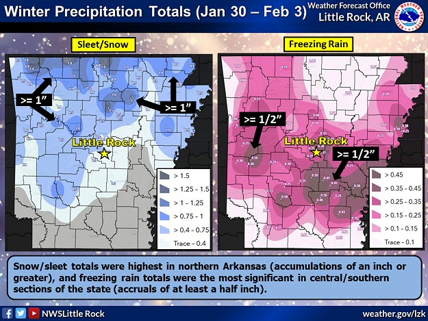
In the picture: Snow/sleet totals were highest in northern Arkansas (accumulations of an inch or greater), and freezing rain totals were the most significant in central/southern sections of the state (accruals of at least a half inch) in the four day period ending at 600 am CST on 02/03/2023.
Things went downhill in a hurry south of Little Rock (Pulaski County) late on February 1st into the morning of the 2nd. One more round of freezing rain developed, and it was devastating.
Nearly a half inch of glaze was measured on exposed objects in places (a bonafide ice storm) including Gillett (Arkansas County), Gurdon (Clark County), Rison (Cleveland County), Sheridan (Grant County), and White Hall (Jefferson County). The weight of the ice brought down trees, tree limbs, and power lines. Tree debris blocked many roads. At one point, there were at least 80,000 power outages.