Interested in what kind of weather occurred in a recent year? Check out the most memorable events below.
Arkansas Yearly Climate Summary (2023)/Pg2
Across Arkansas: Severe Weather/Heavy Rain/Flash Flooding
In the video: A weak tornado (rated EF1) tracked across the Jessieville High School (Garland County) football field during the early afternoon of 01/02/2023. The video is courtesy of the Jessieville School District.
As far as severe weather, the year started off with a bang. On January 2nd, temperatures were in the upper 60s to upper 70s as of 100 pm CST (well above normal readings in the upper 40s to mid 50s). An isolated thunderstorm to the west of Hot Springs Village (Garland/Saline Counties) showed signs of rotation around 230 pm CST. Within ten minutes, a tornado (rated EF1) was spawned at Jessieville (Garland County). The tornado was captured on a security camera at the local high school. The video showed the tornado crossing a football field, and causing destruction along the way. Scarily, the tornado hit while school was in session. There were two minor injuries, but no children were harmed.
Three more tornadoes were counted toward the Louisiana border. The strongest of these (rated EF2) cut a forty three mile swath from roughly two miles south of Berlin (Ashley County) to less than a mile east-southeast of Halley (Desha County). The tornado lasted from 654 pm to 745 pm CST, and reached peak intensity at Montrose (Ashley County). In and near town, a tractor trailer was overturned, a mobile home was rolled over three parked cars, and people were trapped in their homes (which suffered minor to moderate roof damage due to uprooted trees).
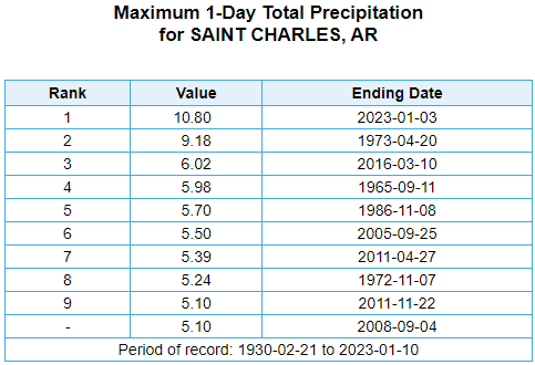
In the pictures: One day rainfall records were set at Saint Charles (Arkansas County) and Cane Creek State Park (Lincoln County) on 01/03/2023.
Meanwhile, there was a deluge in eastern Arkansas. Parts of the southeast picked up more than six inches of rain. One source via email wrote that a few farmers and a flying service surrounding DeWitt (Arkansas County) had amounts close to a foot! National Weather Service cooperative observers at Saint Charles (Arkansas County) and Cane Creek State Park (Lincoln County) tallied 10.80 inches and 7.30 inches of liquid respectively (the highest one day totals on record at these locations).
Numerous highways, homes, and businesses were flooded in southeast Arkansas, and vehicles were stalled in high water. In the northeast, people were evacuated from their homes due to high water in Piggott (Clay County). Bridges were also washed out. It was a similar story in Brookland (Craighead County), Paragould (Greene County), and Walnut Ridge (Lawrence County), with roads converted into lakes, water flowing into structures, and cars stranded.
The Heaviest Rain in 2023?
Early on July 12th, parts of southwest Arkansas received over six inches of rain, including an unofficial report of 12.77 inches of precipitation a few miles north of Waldo (Columbia County). Just southwest of Patmos (Hempstead County) 7.23 inches of liquid was received. Flooding of roads/highway closures occurred from Hope (Hempstead County) to El Dorado (Union County) and Hamburg (Ashley County).
In the pictures: Tornado producing storms (two of them) showed up well on radar (left) and satellite (right) early on 02/16/2023. The storms were part of a line moving across northern Arkansas from Oklahoma.
Several tornadoes spun up in mid-February across the Ozark Mountains. The tornado that made the most headlines (rated EF2) cut a swath from near Pindall (Searcy County) to a few miles southeast of Bruno (Marion County). A house on a hilltop (directly exposed to the wind) shifted off of its concrete slab and partially collapsed. Another home was heavily damaged (loss of roof and an outer wall), and part of a roof was removed from a third home. Barns and sheds were roughed up or destroyed, and trees were uprooted or snapped.
In the picture: Flash Flood Warnings were posted along Highway 70 and Interstate 30 from near Bonnerdale (Hot Spring County) to Hot Springs (Garland County), Benton (Saline County), and Little Rock (Pulaski County) during the morning of 02/24/2023.
On the 24th, a narrow band of heavy rain in central Arkansas prompted Flash Flood Warnings that included Hot Springs (Garland County), Benton (Saline County), and Little Rock (Pulaski County).
At Little Rock (Pulaski County), 4.19 inches of rain fell. This was the second most rain on record in February at the site (the highest amount was 6.00 inches on the 28th in 1875). Hot Springs (Garland County) had 3.13 inches of precipitation, which was the third highest total for the month.
In the picture: The hydrograph at Danville (Yell County) showed the Petit Jean River climbing to a stage of 27.22 feet (major flooding) late on 03/03/2023.
The wettest month was March, especially from west central into central Arkansas where more than double the normal rain dumped in spots. The waterworks initiated during the first few days of the month. In the twenty four hour period ending at 600 am CST on the 3rd, parts of the west had four plus inch totals. Waldron (Scott County) had 4.90 inches of precipitation, with 4.88 inches at Blue Mountain Dam (Yell County), 4.72 inches at Danville (Yell County), 4.45 inches at Abbott (Scott County), and 4.22 inches at Dardanelle (Yell County).
This gullywasher was problematic. The Poteau River at Cauthron (Scott County) rose 15 feet in a hurry. The same swollen river swept a pickup truck off of Highway 80 on the east side of Waldron (Scott County). Tragically, the driver (a grandfather trying to visit his grandson) drowned. The Petit Jean River at Danville (Yell County) had a Top 10 crest of 27.22 feet on the 3rd.
Low Pressure Records
As a storm system intensified and moved over Arkansas early on the 3rd, the barometric pressure at Little Rock (Pulaski County) dropped to 29.12 inches at 640 am CST. This was the lowest pressure since 1969 locally, and the fifth lowest pressure on record. At the North Little Rock Airport (Pulaski County), the pressure bottomed out at 29.07 inches at 635 am CST, which was the lowest pressure since data collection began in 1975.
Before the clouds opened, there was hail slightly larger than baseballs at Woodlawn (Cleveland County) on the 1st, as well as 85 mph thunderstorm wind gusts at Rison (Cleveland County). Gusts this high ripped the roofs off of a church and a strip mall, and removed part of a brick facade from the latter structure. On the 2nd (shortly before 1100 pm CST), a tornado (rated EF2) tossed mobile homes and injured five residents just north of Kirby (Pike County). A couple of chicken houses were obliterated.
There were more downpours (and two to over four inches of rain) over the northern half of the state on the 24th/25th. Five miles northwest of Paron (Saline County), a 68-year-old man on a motorcycle apparently tried to cross a road at the Lake Winona spillway. He was swept off the pavement and down the Alum Fork Saline River where he drowned. At Beebe (White County), a child was pulled into a drainage culvert and got stuck. He was rescued and taken to the nearest hospital.
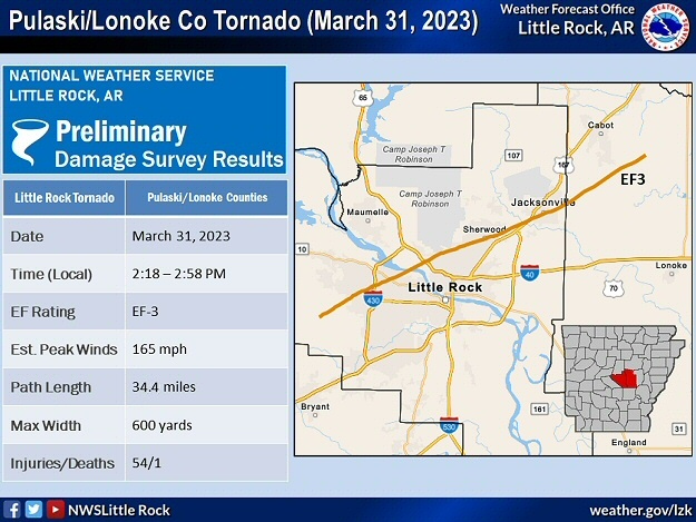
In the pictures: There were three tornadoes confirmed in the Little Rock County Warning Area on 03/31/2023. The strongest of these (rated EF3/165 mph peak wind) tracked just over thirty four miles from west Little Rock (Pulaski County) to the south side of Cabot (Lonoke County). Since the year 2000 in Arkansas, tornadoes of this magnitude or higher occur only 3 to 4 percent of the time, but account for almost 80 percent of tornado fatalities. The tornado and its classic signs (strong rotation, debris ball, etc) were picked up by the WSR-88D (Doppler Weather Radar) along Interstate 40 near Burns Park in North Little Rock (Pulaski County) at 229 pm CDT. National Weather Service employees at the North Little Rock Airport (Pulaski County) headed to shelter temporarily as the tornado went by to the south (within a mile).
And then there was the episode of the year on March 31st. A massive tornado outbreak unfolded from Iowa to Arkansas and areas farther east through the Ohio and Tennessee Valleys. Locally, the nightmare scenario involved mainly the central third of the state.
Two storms proved to be the most wicked, and storm number one prompted a Tornado Warning for the Little Rock (Pulaski County) area at 203 pm CDT. The situation got much worse from there. A tornado quickly spun up at 218 pm CDT and began causing destruction about five miles west-southwest of the intersection of Interstates 430 and 630. When it was clear the situation was becoming catastrophic/life threatening, a Tornado Emergency was posted at 228 pm CDT.
The tornado (rated EF3/165 mph peak wind) tracked just over thirty four miles from west Little Rock through North Little Rock, Sherwood and Jacksonville (all in Pulaski County) before finally weakening on the southeast side of Cabot (Lonoke County).
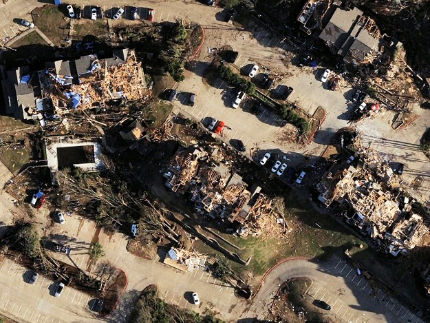
In the pictures: Following a tornado (rated EF3) on 03/31/2023, damage surveys pinpointed several areas with the most significant damage in west Little Rock (along Napa Valley Drive, North Shackleford Road, and Walnut Valley Drive) and Jacksonville (all in Pulaski County) on 03/31/2023. Some of the ground photos (video stills of the Napa Valley Drive apartments and the North Shackleford Road houses) were provided by Brian Emfinger.
There were at least 2,700 structures impacted and 60,000 power outages (many of these in Pulaski County). More than fifty people were injured and admitted to hospitals. Miraculously, only one person was killed (but not directly due to the tornado).
Some of the worst damage happened in west Little Rock (Pulaski County) between Napa Valley Drive and Interstate 430, and also in Jacksonville (Pulaski County).
Insult to Injury in September
On September 6th, a microburst (damaging wind plummeting to the ground from a thunderstorm and diverging) was observed in the same area of west Little Rock (Pulaski County) that was devastated by a tornado (rated EF3) on March 31st. Trees were blown onto houses. A home destroyed by the tornado and in the process of being rebuilt was leveled by the microburst.
Farther east, storm number two spawned a tornado (rated at least EF3) that carved a path through Wynne (Cross County) around 445 pm CDT. Structures were flattened, and at least four fatalities resulted. A high school took a direct hit, but nobody was there (classes were canceled earlier in the afternoon). Farther downstream, the same tornado wreaked havoc just west of Parkin (Cross County) and north of Earle (Crittenden County). South of Turrell (Crittenden County), a truck was tipped over on Interstate 55. The tornado eventually crossed the Mississippi River and dissipated near Burlison, TN (a 73 mile trek).
Another strong tornado (rated EF2) between Alco and Fifty-Six (both in Stone County) separated a house from its foundation and removed the roof at 449 pm CDT. Weaker tornadoes were confirmed about five miles southeast of Hickory Plains (Prairie County) and close to Lexa (Phillips County).
One for the Record Books
Across the country, the severe weather outbreak of March 31st/April 1st, 2023 made the Top 3 list for the number of tornadoes produced in a twenty four hour period. An impressive 137 tornadoes were documented (with 147 tornadoes during the entire outbreak). In case you are wondering, number one and two on the list are the super outbreaks of April 25th through the 28th, 2011 (216 tornadoes) and April 3rd and 4th, 1974 (148 tornadoes).
In the picture: Swaths of large hail revealed the paths of severe storms (mostly from northwest to southeast) on 06/14/2023. Hail was up to two inches in diameter during the morning, and up to softball size (four inches in diameter) in the afternoon/evening.
In June, there was way too much hail. Almost two dozen reports of two inch diameter hail (hen egg size) or larger were received on the 14th. One storm in particular deposited up to softball size hail from northeast of Sims (Montgomery County) to the Hot Springs (Garland County) area, Malvern (Hot Spring County), and Star City (Lincoln County). Another storm unloaded softball size stones near DeGray (Clark County), with a third storm chunking out tennis balls northwest of Birta (Yell County) and just north of Springfield (Conway County).
Baseball Size Hail or Larger (June 14, 2023)
Location
Hail Size (Inches)
2 NW Crystal Springs (Garland County)
4.00
DeGray (Clark County)
4.00
Royal (Garland County)
4.00
2 NNE Sims (Montgomery County)
4.00
3 WNW Slabtown (Grant County)
4.00
Star City (Lincoln County)
4.00
2 NE Lake Hamilton (Garland County)
3.00
1 S Malvern (Hot Spring County)
3.00
3 SSW Abco (Hot Spring County)
2.75
Pearcy (Garland County)
2.75
2 NW Royal (Garland County)
2.75
Note: Miles and directions from locations are shown, such as "2 NW" (two miles northwest) or "3 SSW" (three miles south-southwest).
In the video: Hail up to softball size pelted the south side of Hot Springs (Garland Co) on 06/14/2023, including areas around Lake Hamilton. The video is courtesy of Lou Petitford.
On the 16th, baseball size hail dropped from the sky at Hot Springs Village (Garland County), east of Traskwood (Saline County), and Sheridan (Grant County).
Grapefruit size hail pelted Thola (Searcy County) on the 25th, with hail slightly larger than baseballs a few miles northwest of Gold Hill (Pope County), Landis (Searcy County), Mountain View (Stone County), and Timbo (Stone County). Salus (Johnson/Newton Counties) got tennis ball size hail.
By the time the month was over, there was more very large hail (two inches in diameter or bigger) than in any other June on record in Arkansas.
How Rare is Huge Hail?
With the exception of 2005 and 2013, baseball size or larger hail was observed in Arkansas at least once a year since 1980 (through 2023). Hail at least softball size occurred once every other year (23 of 44 years). As far as numbers of reports, of the roughly 6,342 instances of quarter size or larger hail, 2,641 were at least golf balls (41.6% of reports), 292 were at least baseballs (4.6% of reports), and 60 were at least softballs (0.9% of reports). The largest hailstones were five inches in diameter (slightly larger than a DVD) on January 21, 1999; April 2, 2006; and May 4, 2020.
A tornado was confirmed by radar early this morning near Scranton (Logan Co). The tornado occurred in an area of rotation (circle with arrow) on the north side of a ball of wind (in red). Chicken houses were destroyed, barns were damaged, and trees were on houses and cars.#arwxpic.twitter.com/dAidQTnIPq
In the video: A tornado was confirmed by the WSR-88D (Doppler Weather Radar) near Scranton (Logan County) early on 06/18/2023. The tornado occurred in an area of rotation (circle with arrow) on the north side of a ball of wind (in red).
While the hail was impressive in June, so was the wind. On the 18th, thunderstorm wind gusts caused 100,000 power outages across the state. Also, there were tornadoes (both rated EF2) that spun up two to three miles south of Scranton (Logan County), and from seven miles southeast of Calion (Union County) to eight miles north-northeast of Strong (Union County). The last time two tornadoes of at least this intensity materialized on the same day in June was in 1979 (on the 28th).
There will be a lot of trees down across central Arkansas late this afternoon/early this evening. Here is a tree that fell through a house in Conway (Faulkner County).#arwxhttps://t.co/bVzP2K1cDg
In the picture: A tree fell through a house in Conway (Faulkner County) during the afternoon of 06/25/2023. The photo is courtesy of Brandon Miller via X (formally Twitter).
On the 25th, gusts from 75 to 80 mph were measured near McCreanor and Tomberlin (both in Lonoke County). A 69 mph gust was recorded at Little Rock National Airport (Pulaski County), and Swifton (Jackson County) had a 68 mph gust. The wind gusted to 60 mph at DeWitt (Arkansas County), and 59 mph at Jonesboro Municipal Airport (Craighead County). Tree and/or power pole damage was widespread. A whopping 150,000 utility customers lost power! According to one media source, a local official in Conway (Faulkner County) called it the worst storm damage in decades. A tree landed on a mobile home at Carlisle (Lonoke County) and killed two people (another occupant was injured).
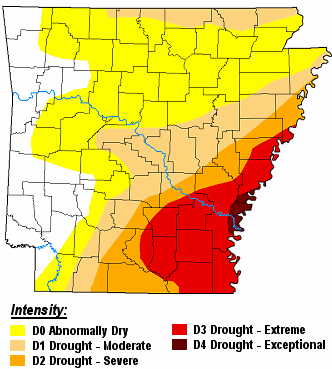
In the picture: There were moderate drought (D1) conditions along the Missouri border, and moderate to exceptional drought (D1 to D4) conditions from central into southeast Arkansas on 12/26/2023.
While 2023 started very wet, conditions dried out in a hurry toward the end of the year. Drought developed during the summer and worsened in the fall/early winter, especially from the central into southeast Arkansas.
Triple Digit Heat
Drought conditions worsened due to a lack of rain and extreme heat. Triple digit temperatures were experienced during the summer/early fall (June through September). Readings hit 100 degrees or higher on 24 days at Texarkana (Miller County), 23 days at Fort Smith (Sebastian County), 20 days at Pine Bluff (Jefferson County), 15 days at Little Rock (Pulaski County), and 14 days at Hot Springs (Garland County). The hottest readings were in August, with the mercury topping out at 105 degrees at Hot Springs (Garland County), and 107 degrees at the remaining aforementioned sites.
In the southeast, eight to twelve inch rainfall deficits were common from October 1st through December 31st. Exceptional drought (D4) conditions were observed for the first time since October, 2015 in the state.
Precipitation From October 1 to December 31, 2023
Site
Amount
Normal
+/-
% of Normal
Little Rock (C AR)
10.67
14.27
-3.60
75%
Pine Bluff (SE AR)
9.25
13.85
-4.60
67%
Monticello (SE AR)
5.56
14.38
-8.82
39%
Now it's time to check out significant events in 2023 outside of Arkansas. To check out the rest of the story, click here.