|
| Yearly Reports |
| Interested in what kind of weather occurred in a recent year? Check out the most memorable events below. |
|
|
 |
Arkansas Yearly Climate Summary (2014) |
 |
| |
|
| 2014 Statistics |
| Month |
Tornadoes |
Tornado Deaths |
Dmg Wind Deaths |
Flood/Flash Flood Deaths |
Lightning Deaths |
| Jan |
0 |
0 |
0 |
0 |
0 |
| Feb |
0 |
0 |
0 |
0 |
0 |
| Mar |
0 |
0 |
0 |
0 |
0 |
| Apr |
6 (EF0: 1, EF1: 3,
EF2: 1, EF4: 1) |
16 |
0 |
0 |
0 |
| May |
1 (EF1: 1) |
0 |
0 |
0 |
0 |
| June |
2 (EF1: 2) |
0 |
3 |
0 |
0 |
| July |
0 |
0 |
0 |
0 |
1 |
| Aug |
0 |
0 |
0 |
0 |
0 |
| Sep |
1 (EF0: 1) |
0 |
0 |
0 |
0 |
| Oct |
10 (EF0: 3, EF1: 6,
EF2: 1) |
1 |
1 |
0 |
1 |
| Nov |
0 |
0 |
0 |
0 |
0 |
| Dec |
0 |
0 |
0 |
0 |
0 |
| Total |
20 |
17 |
4 |
0 |
2 |
| Note: The latest tornadoes (7 of them) were spawned on October 13th. The tornadoes were generally weak (rated EF0/EF1). There was a stronger tornado (rated EF2) between Ashdown and Foreman (both in Little River County) that resulted in a fatality. The strongest and deadliest (16 fatalities) tornado (rated EF4) tracked through areas in/near Roland (Pulaski County), Mayflower (Faulkner County), Vilonia (Faulkner County) and El Paso (White County) on April 27th. Of the 624 tornadoes across the state since 2000 (through 2014), this was only the 3rd tornado of this magnitude. |
| Average Temperatures in 2014 |
| Site |
Avg Temp |
+/- |
| Fayetteville (NW AR) |
55.3° |
-1.8° |
| Harrison (NC AR) |
56.3° |
-1.6° |
| Jonesboro (NE AR) |
58.0° |
-2.0° |
| Fort Smith (WC AR) |
60.7° |
-1.0° |
| Little Rock (C AR) |
61.0° |
-1.7° |
| West Memphis (EC AR) |
59.3° |
-1.7° |
| Texarkana (SW AR) |
62.4° |
-1.5° |
| El Dorado (SC AR) |
61.4° |
-2.1° |
| Pine Bluff (SE AR) |
60.6° |
-2.3° |
| Note: It was the 6th coolest (115th warmest) year on record dating back to 1895. The statewide average temperature of 58.7 degrees was 1.7 degrees below normal. This was determined by the National Climatic Data Center in Asheville, NC. |
| Precipitation in 2014 |
| Site |
Amount |
Normal |
+/- |
% of Normal |
| Fayetteville (NW AR) |
39.08 |
48.51 |
-9.43 |
81% |
| Harrison (NC AR) |
41.20 |
44.14 |
-2.94 |
93% |
| Jonesboro (NE AR) |
44.15 |
48.10 |
-3.95 |
92% |
| Fort Smith (WC AR) |
42.14 |
45.46 |
-3.32 |
93% |
| Little Rock (C AR) |
48.13 |
49.75 |
-1.62 |
97% |
| West Memphis (EC AR) |
49.08 |
52.23 |
-3.15 |
94% |
| Texarkana (SW AR) |
35.24 |
49.65 |
-14.41 |
71% |
| El Dorado (SC AR) |
41.03 |
52.92 |
-11.89 |
78% |
| Pine Bluff (SE AR) |
41.41 |
51.15 |
-9.74 |
81% |
| Note: It was the 56th driest (65th wettest) year on record dating back to 1895. The statewide average precipitation of 47.84 inches was 1.76 inches below normal. This was determined by the National Climatic Data Center in Asheville, NC. |
|
It was the second coldest start to a year since 1985 (it was colder in 2010). Through January and February, average temperatures were 4.2 degrees below normal. Several snow and ice events were noted, but the most significant episode unfolded on March 2nd.
|
 |
| In the picture: Sleet accumulated at Conway (Faulkner County) during the evening of 03/02/2014. The photo is courtesy of Steve Love via Facebook. Click to enlarge. |
|
 |
| In the picture: After a period of freezing rain, sleet also piled up at Searcy (White County). The photo is courtesy of Debbie Wantulok via Facebook. Click to enlarge. |
|
| |
|
Temperatures across Arkansas varied by more than 50 degrees. There were scattered hailstorms, several inches of sleet and a massive traffic jam in eastern sections of the state that forced motorists to sleep in their vehicles. Many vehicles ran out of gas.
|
| Wrong Place, Wrong Time |
| Event: In the couple of days following this event (on March 3rd/4th), there were huge traffic jams along Interstates 40 and 55 in eastern Arkansas. Many motorists were stranded for so long they had to sleep in their vehicles. There were reports of vehicles running out of gas. It was a mess. So, what happened? |
| So Much Ice: This was primarily a sleet and freezing rain event across the eastern counties. The freezing rain came first, and was followed by a lot of sleet. At the National Weather Service in North Little Rock (Pulaski County), one forecaster with almost four decades of experience mentioned that he had never witnessed this much sleet (several inches) over such a large area. |
| So Cold: The high temperature on the 3rd was only 23 degrees at West Memphis (Crittenden County), and the mercury maxed out at only 28 degrees on the 4th. This was about as cold as it has ever been (on record) in March. Persistent clouds kept the sun from coming out. Lows were in the teens to start both days. It was hard for ice to melt on bridges and overpasses directly exposed to the cold. |
| Black Ice: While air temperatures did not cooperate, the ground was warm enough to cause melting. Soil temperatures at Marianna (Lee County) on the 3rd ranged from 35 to 40 degrees, and this slowly converted ice to water on roadways. But once the sun went down, the conversion tended to reverse and water turned to glaze. |
| Accidents: Trucks jackknifed and cars slid into each other. Slow progress grinded to a halt as ice related incidents escalated. |
| Construction: Ongoing road construction did not help the situation, particularly around Forrest City (St. Francis County). With vehicles at a standstill, it was difficult for road crews to treat the pavement. |
 |
| In the picture: Estimated snow and ice totals in the twenty four hour period ending at 600 am CST on 03/03/2014. |
|
| |
|
Record cold high temperatures for the month were set on the 3rd (readings in the 20s), and wind chill indices dropped below zero across the northern counties. In the northwest, indices were between 10 and 15 degrees below zero during the predawn hours.
Looking at winter as a whole, there was more than the usual snow and sleet toward the Ozark Mountains of the northwest. At Harrison (Boone County), 15.8 inches was measured (8.7 inches is normal), with 14.1 inches (5.6 inches is normal) at Fayetteville (Washington County) and 10.2 inches (4.3 inches is normal) at Fort Smith (Sebastian County). While climatological spring began on March 1st, visits from Canada did not stop. Two storms (on the 2nd/3rd and the 16th) dumped 10.0 inches of snow/sleet at Harrison (Boone County). It was the 4th snowiest March locally (the record is 14.5 inches in 1970).
|
 |
The severe weather season (spring) got off to a slow start given continued cool weather (more warmth and moisture was needed to fuel thunderstorms). Even so, it did get active in April. Bowing storms (with damaging straight-line winds) swept out of Texas into southern Arkansas late on the 3rd and early on the 4th.
|
| In the picture: Thunderstorm gusts over 80 mph caused extensive damage at Fairview High School in Camden (Ouachita County) early on 04/04/2014. Click to enlarge. |
|
At Camden (Ouachita County), a high school was hit by 85 mph gusts (confirmed by a National Weather Service damage survey), with roofs peeled back from buildings. The stadium was also affected. Classes were called off on the 4th.
Power was knocked out to at least 50,000 customers across the south. At Sparkman (Dallas County), this led to a tragedy. Candles were blamed for a house fire that killed two children.
|
| On April 27th, five (5) tornadoes were spawned, and one was exceptionally destructive. This monster tornado tracked 41 miles through Mayflower and Vilonia (both in Faulkner County) before dissipating near El Paso (White County). This was by far the biggest event of the year so far. The tornado was given a rating of EF4 (166-200 mph winds). Sixteen people lost their lives, making this the deadliest single tornado in Arkansas since the Jonesboro (Craighead County) twister of May 15, 1968 (35 fatalities). |
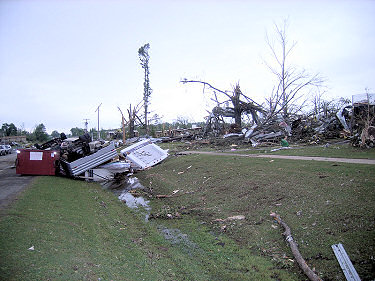 |
| In the picture: Everything was torn up by tornado (rated EF4) along Highway 365 in Mayflower (Faulkner County) on 04/27/2014. Click to enlarge. |
|
Besides tornadoes, there were a lot of high water problems in northeast sections of the state on the 27th and early on the 28th. The price tag on road and bridge repair (due to water) was an estimated $1.5 million in Lawrence and Sharp Counties. A whopping 7.60 inches of rain was measured at Batesville Lock and Dam (Independence County). This was the most for one day since records were established in 1904.
Twelve (12) counties were declared federal disaster areas following this event. This was for tornado and flood related costs.
|
|
Spring finished as the second coolest March through May since 1993 (average temperatures were subpar by 2.0 degrees). There were only seven (7) tornadoes for the year. Not much changed in the summer, with a lack of heat and periodic rain. Days with 95 degree temperatures were few.
|
| 95 Degree Days in June/July/August |
| Site |
2014 |
Avg 2000-2013 |
| Fayetteville (NW AR) |
2 |
15 |
| Harrison (NC AR) |
2 |
14 |
| Jonesboro (NE AR) |
7 |
24 |
| Fort Smith (WC AR) |
15 |
37 |
| Little Rock (C AR) |
8 |
30 |
| West Memphis (EC AR) |
2 |
18 |
| Texarkana (SW AR) |
13 |
40 |
| El Dorado (SC AR) |
6 |
35 |
| Pine Bluff (SE AR) |
4 |
26 |
 |
| In the picture: A front stalled to the south of Arkansas on 07/17/2014, with a storm system ("L") in Texas spreading clouds and rain into the area north of the front. A cool east wind around high pressure ("H") in Illinois kept temperatures well below normal. |
|
| |
|
On July 4th, the mercury maxed out at 83 degrees in Little Rock (Pulaski County). It was the coolest July 4th since 1976 (76 degrees), and only the 5th time since 1950 readings failed to reach at least 85 degrees. On the 17th, clouds and rain kept high temperatures in the 60s/70s. Some of these highs were historic; that is, daytime readings had never been this low in July. This was the case at Hot Springs National Park (Garland County), Malvern (Hot Spring County) and Mena (Polk County), with highs of 64, 67 and 63 degrees respectively. Records for these sites go back into the late 1800s! It was no wonder that the state experienced a record cool July.
|
|
|
There were clusters of severe storms at times in the summer. In early June, storms ripped through northern and central Arkansas. On the 5th, a tree fell on a van at Black Rock (Lawrence County) and trapped people inside. One person was killed. At Jonesboro (Craighead County), a tree hit a house and killed the occupant. |
| In the pictures: The satellite showed storms advancing quickly eastward through Arkansas from 930 am to 330 pm CDT on 06/06/2014. |
|
The next day, a boat capsized on Beaverfork Lake (Faulkner County) as thunderstorm winds increased. A fisherman was thrown into the water and drowned. There were two weak (rated EF1) tornadoes on the 6th, including a brief tornado on the north side of Batesville (Independence County).
|
 |
| In the picture: Twenty four hour rainfall through 700 am CDT on 06/29/2014. |
|
| |
|
A significant heavy rain event unfolded during the wee hours of June 29th. In the twenty four hours ending at 700 am CDT, Little Dixie (Woodruff County) got a staggering 10.32 inches of precipitation! At Howell (Wooodruff County), 9.66 inches fell, with 7.45 inches at McCrory (Woodruff County), 7.10 inches at Georgetown (White County), 6.60 inches at Madison (St. Francis County), 5.34 inches at Oil Trough (Independence County) and 4.75 inches at Des Arc (Prairie County).
A 24-hour rainfall record was snapped at Augusta (Woodruff County), with 7.50 inches edging the previous record of 7.30 inches on November 19, 1988.
|
 |
| Before Rain | After Rain |
| In the pictures: A field was turned into a lake at McCrory (Woodruff County) on 06/29/2014. The photos are courtesy of LeAnne Gaddy via Twitter. |
|
| |
|
Rising water led to evacuations of homes, especially in Crittenden, Monroe, St. Francis and Woodruff Counties. Main thoroughfares were blocked by water and closed, including U.S. Highway 49. The Cache River at Patterson (Woodruff County) swelled to over 11 feet (flood stage is 8 feet), and this flooded thousands of acres of farmland. Federal disaster declarations were made in ten (10) counties.
|
 |
| In the picture: Temperatures reached at least 100 degrees at eleven sites from central into northeast Arkansas on 08/23/2014. |
|
| |
|
It did get hot on August 23rd. Thermometers reached at least 100 degrees at a dozen reporting stations. This included 102 degrees at Salem (Fulton County), and 101 degrees at Mammoth Spring (Fulton County), Morrilton (Conway County) and Mountain Home (Baxter County).
|
| High Temperatures on 08/23/2014 |
| Site |
Temperature |
| Salem (Fulton Co) |
102° |
| Mammoth Spring (Fulton Co) |
101° |
| Morrilton (Conway Co) |
101° |
| Mountain Home (Baxter Co) |
101° |
| Batesville Airport (Independence Co) |
100° |
| Batesville Lock and Dam (Independence Co) |
100° |
| Clinton (Van Buren Co) |
100° |
| Evening Shade 1 NNE (Sharp Co) |
100° |
| Flippin (Marion Co) |
100° |
| Hardy (Sharp Co) |
100° |
| Jonesboro 2 NE (Craighead Co) |
100° |
| Mountain View (Stone Co) |
100° |
| Note: With the exception of Batesville Airport (Independence County), Clinton (Van Buren County) and Flippin (Marion County), the stations listed above have a 24-hour reporting period ending around 700 am CDT. Therefore, while the readings occurred on the 23rd, they were credited to the 24th. |
 |
| In the picture: Percent of normal rainfall from July 3rd through September 30th, 2014. |
|
| |
|
Heading into the fall, it was a quiet September (a lack of rain and one weak tornado on the 17th). As the month ended, there had not been a decent rain (at least a quarter of an inch) at most reporting stations in two to three weeks. Longer term, it was really dry in the northeast since early July. Several spots from Batesville (Independence County) and Searcy (White County) eastward toward Jonesboro (Craighead County) and West Memphis (Crittenden County) got only two to four inches of precipitation. This was four to six inches below normal (25 to 50 percent of normal). A moderate drought (D1) developed in the northeast by the 30th (on a drought severity scale from D0 or "abnormally dry" to D4 or "exceptional drought").
|
|
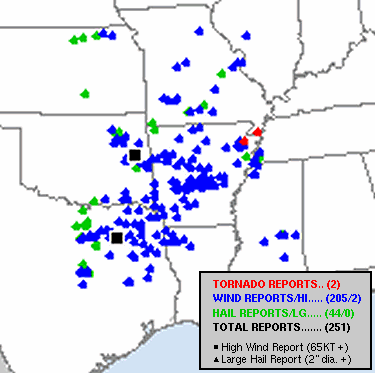
Thunderstorms came to life during the first two weeks of October. Widespread wind damage was reported on the 2nd.
|
|
| In the picture: Storm reports through 1200 am CDT on 10/03/2014. The graphic is courtesy of the Storm Prediction Center. |
|
Wind gusts reached 60 to 80 mph in places, including measured gusts of 76 mph just southeast of Sheridan (Grant County) and 68 mph at Fairmount (Prairie County). This led to a lot of reports of downed trees and power lines. Three weak tornadoes (rated EF0/EF1) were identified by the National Weather Service.
A huge tree smacked into a home at Malvern (Hot Spring County). An infant was rescued from the home. Tragically, a man inside the home was killed.
|
 |
| In the picture: These cotton plants were wiped out by hail near Black Oak (Craighead County) early on 10/07/2014. The photo is courtesy of Jason Osborn (University of Arkansas System Division of Agriculture) via Twitter. |
|
| |
|
Late on the 6th/early on the 7th, hit and miss hailstorms erupted from northeast sections Arkansas into western Tennessee and northern Mississippi. The hail (bigger than quarters) caused significant damage to cotton crops in the northeast, especially in Craighead and Mississippi Counties. At least 25,000 acres of cotton were affected just days before harvest.
A week later (on the 13th), a line of storms arrived from Oklahoma in the morning and brought more wind. There were also isolated mainly weak (rated EF0/EF1) tornadoes. Damage surveys determined that seven (7) tornadoes occurred. This is the most tornadoes counted during any event in 2014.
The strongest of these (rated EF2) tracked between Ashdown and Foreman (both in Little River County). Several houses were damaged, with one home completely destroyed. At least four people were injured, and there was a fatality.
|
|
|
| In the picture: Average temperatures (blue bars) at Little Rock (Pulaski County) in mid-November, 2014. These were well below normal readings (orange bars). |
|
| |
|
In November, winter arrived early. From the 12th through the 18th, average temperatures were mostly in the 30s at Little Rock (Pulaski County). This was roughly 15 to 25 degrees under normal mercury levels in the lower to mid 50s.
|
| Coldest Average Temperatures on November 12-18 at Little Rock (Pulaski County) |
| Year |
Avg Temp |
| 2014 |
35.3° |
| 1920 |
35.8° |
| 1940 |
39.4° |
| 1880 |
39.6° |
| 1959 |
39.9° |
| 1997 |
40.5° |
|
On the morning of the 18th, the thermometer showed 8 degrees at Gilbert (Searcy County) and Evening Shade (Sharp County), with 9 degrees at Fayetteville (Washington County). These were the first single digit temperatures in November across Arkansas since 1997.
It snowed in some areas early on the 13th. While there was only a dusting (0.1 inch) at Little Rock (Pulaski County), it was the third earliest accumulation on record (behind 11/02/1951 and 11/09/1892). Local records go back to 1874. A similar amount was measured at Pine Bluff (Jefferson County), making it the earliest recorded (since 1883) snow at the site.
On the 16th, a narrow band of heavier snow set up from Waldron (Scott County) to Morrilton (Conway County) and Hardy (Sharp County). Two to four inch accumulations were noted in these areas.
|
|
|