Central Illinois
Weather Forecast Office
Tornado #6: Garrett Tornado (Moultrie and Douglas Counties)
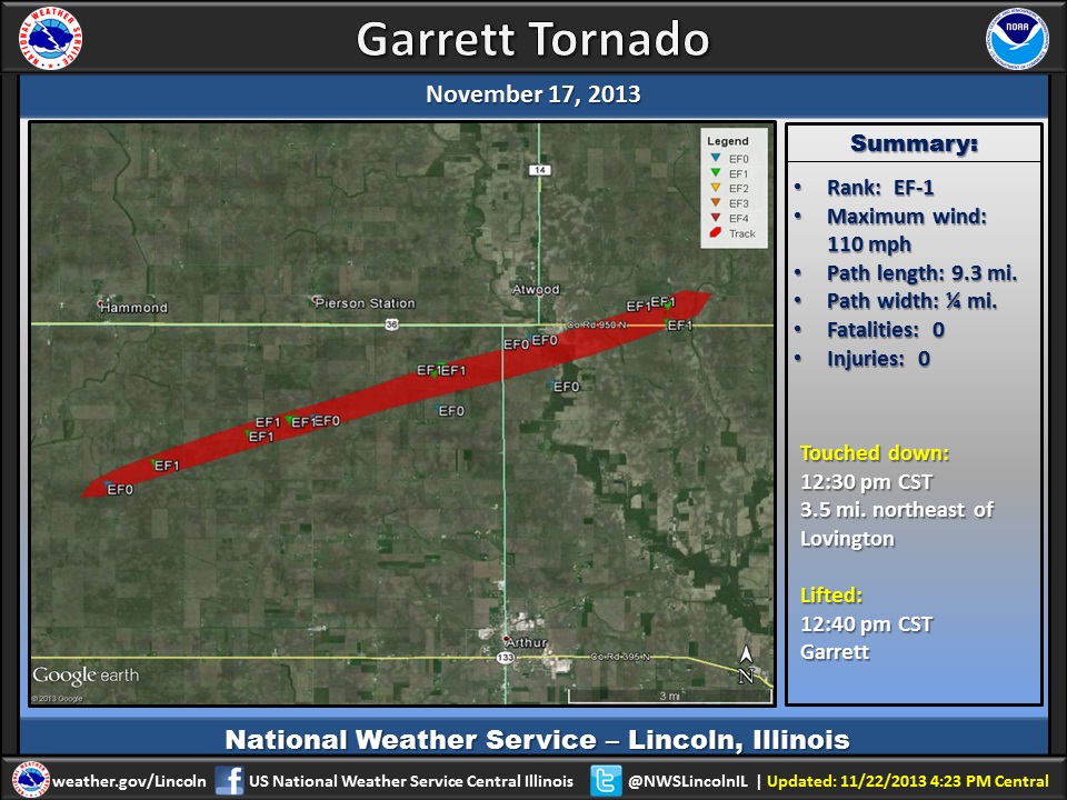
Summary:
| Rating: | EF-1 |
| Peak wind: | 110 mph |
| Touched down: | 12:30 pm CST 3.5 miles northeast of Lovington (Moultrie County) |
| Lifted: | 12:40 pm CST 2.4 miles east of Atwood (Douglas County) |
| Path length: | 9.3 miles |
| Path width: | 0.25 mile |
| Fatalities: | 0 |
| Injuries: | 0 |
Survey Results:
The tornado touched down in an open field about 3.5 miles northeast of Lovington, then tracked northeastward and crossed into Douglas County about 5 miles north of Arthur at 12:37 PM CST. In Moultrie County, major roof damage occurred to 8 homes, while 1 garage was destroyed and 17 outbuildings were severely damaged. Numerous trees and power poles were snapped. In Douglas County southwest of Garrett, the tornado damaged the roofs of 3 homes and 5 outbuildings, as well as numerous trees and power poles. It crossed U.S. Highway 36 and tracked into the town of Garrett where it damaged the roofs of about two dozen homes and mobile homes before dissipating.
Event Links: Overview | Pekin | Washington | Pana | Altamont | West Liberty
Garrett | Gifford | Villa Grove | Tuscola | Westville | Radar
US Dept of Commerce
National Oceanic and Atmospheric Administration
National Weather Service
Central Illinois
1362 State Route 10
Lincoln, IL 62656
217-732-7321 (forecast recording) or 217-732-3089
Comments? Questions? Please Contact Us.

