Withering Drought, Persistent Heat in the Valley 2011 Breaks Records for Low Rainfall, Warm Temperatures |
|||||||||||||||||||||||||||||||||||||||||||||||||||||||||||||
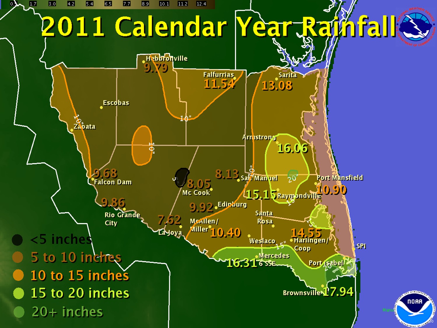
|
In Brief Continue reading for a capsule of the many weather stories through 2011. Links are provided to take you to the full details of each event. |
|||||||||||||||||||||||||||||||||||||||||||||||||||||||||||||
| January to March: From Bone Chilling to Tropical Breezes | |||||||||||||||||||||||||||||||||||||||||||||||||||||||||||||
|
The start of a record water year drought in October 2010 continued in the New Year. Almost on cue, January began with a massive wildfire on the King Ranch on Sunday the 2nd. Seven to eight thousand acres burned in Kenedy County, with additional fires in Hidalgo County. The fire culminated a very dry period which began on October 1st, 2010. Some relief would arrive the following week, as the first cold, drizzly pattern brought temperatures down into the 30s and 40s day and night between the 11th and 13th. A coastal trough developed on the 14th and provided welcome rains of 2 to 3 inches from the Lower Valley through the King Ranch. February provided the most memorable single weather event of 2011. A true arctic front sliced through Texas on the 31st and 1st. Daytime temperatures plunged into the single digits across the Panhandle, and teens and twenties across North and Central Texas on the 1st. Groundhog Day (February 2nd) saw the air mass into the Valley, with daytime temperatures holding around or just above freezing (32°F) under a steely gray sky. An upper level disturbance arrived on the 3rd, and lifted just enough moisture into an icy drizzle and light rain, which continued until early on the 4th before the sun reappeared and temperatures gradually recovered. Up to 1 1/2 inches of ice accreted on exposed surfaces; all elevated roads were closed in the Valley between the afternoon of the 3rd and around noon on the 4th. Early awareness was critical to road, school, and business closures ahead of the ice storm. Still, there were more than 170 vehicle accidents, dozens of injuries in accidents and slips/falls, and one death from a rollover in Willacy County. Gusty northwest winds to 30 mph at times made it feel more like 15°F to 25°F through the entire event &ndash 48 hours or more, and freezing temperatures in some areas began late on the 1st and continued through the 4th. Click here for full details. The 2011 Freeze and Ice Storm was not the end of winter’s chill; another front brought overnight temperatures back down into the 20s and lower 30s February 10th/11th. And, just like that – poof! Winter ended. Turning on a climatological dime, temperatures raced well above average for the last half of the month. A month that began with arctic chill, ice, and average temperatures just below 50°F at Harlingen for the first thirteen days, more than 11 degrees below what it should be, ended in solid spring. The second half had average temperatures well above 70°F. Thus ended winter 2010/2011, which was a "sandwich" of warmth and dry ‘bread’ (December and the end of February) covering a chilly middle (mid January through mid February). Spring began earnestly in March. Warm, breezy days and balmy nights dominated, with only two breaks in the warmth, on the 6th behind a cold front, and briefly on the 30th. Rain was virtually non–existent as La Niña aided a northward migration of the jet stream. This departure allowed May–like temperatures and humidity to dominate long stretches of the month. Increasing sun angle began taking a toll on deep soil moisture. Brief greenup was no match for the lack of rain, which spread severe drought conditions across all but the King Ranch by month’s end. |
|||||||||||||||||||||||||||||||||||||||||||||||||||||||||||||
| April to June: Heat, Drought Begins to Impact Crops and Livestock | |||||||||||||||||||||||||||||||||||||||||||||||||||||||||||||
|
Heat, Wind, and Fire (Weather) would be the story of the spring, a relative turnaround from the wetter and occasionally stormy spring of 2010. April was the month of accelerated drought, courtesy of four individual cases of "blast furnace" events which combined gusty, drying northwest winds, near triple–digit temperatures, and afternoon humidity below 20 percent inland. The first, and most impressive, of these was April 4th. Widespread triple digit heat combined with gusty winds above 40 mph and afternoon humidity between 10 and 20 percent to create a flash drought; fortunately, no wildfires were reported on such a critically dangerous day. Additional fires would develop through the month, burning more than a thousand acres and causing minor injuries to three firefighters. Record to near record heat occurred across the Valley in April; drought became extreme for all but the coast and King Ranch by month’s end. May falls at the tail of meteorological spring (March to May), but in 2011, May was really the start of a long, hot summer. A flirtation with comfortable temperatures much of the first week was erased by the 7th. Thereafter, daytime temperatures in the 90s and low 100s and nighttime temperatures falling from the 80s into the 70s prevailed, except for a brief reprieve between the 14th and 17th. This reprieve followed the first rains in more than 60 days on May 12th. The only significant thunderstorms of the spring occurred on May 15th and again on the 20th. Hail the size of dimes to golfballs accompanied scattered storms moving west to east across the Valley, from Zapata to the northern edge of South Padre Island on the 15th, and a heat spike fed by the central Valley dry line sparked welcome rain and hail storms across the ranchlands. May concluded a record to near record hot and dry spring (March to May). Summer swelter continued deep into June. Temperatures a few degrees above average to start the month soared to nearly 10 degrees above average between June 15th and 21st, with daytime average highs at or above 100°F, evening temperatures remaining at or above 90, and morning lows hovering around 80°F. The unrelenting heat, wind, and generally low afternoon humidity surged drought to the worst possible level – Exceptional – for all but the King Ranch and Brooks County hunting grounds. This was the first widespread Exceptional Drought condition across the Valley since August 2009. From March to May, the hot, dry, breezy conditions had not contributed to any conflagrations. That would change in June. Between the 9th and 12th, several fires would burn more than 5,000 acres in Zapata, Brooks, and Hidalgo Counties. Those were a prelude to the largest single wildfire since 2008. Sparks from a hot catalytic converter likely set off the 32,000 acre conflagration known as the SMAC Ranch Complex. The pinnacle of the hot, dry June occurred on the 21st. Immediately following the mini heat wave, relief arrived in the form of a thunderstorm system which surged through the south Texas plains and into the ranchlands. The storms provided a big assist to fire crews on the SMAC Ranch fire on the 22nd, and boundaries from the morning activity triggered afternoon storms in the Lower Valley. For some neighborhoods, the rain was too much too soon. Clogged drainage ditches overflowed, and other roads flooded in eastern Hidalgo County where more than 5 inches fell in a short period of time. Additional rain fell in Cameron, Willacy, and eastern Hidalgo County on the 23rd; 4 to 6 inches fell in these areas for the event. Close on the heels of the welcome thunderstorms were the outer bands of Tropical Storm Arlene, which produced additional helpful rains of 1 to 3 inches from eastern Hidalgo through Cameron County on the 29th and 30th. A rotating thunderstorm on the edge of the outer bands dropped the year’s only notable tornado, an EF–1 rated twister with 90 mph winds, in Pharr/Hidalgo. The first half of the calendar year closed with mixed results: Some relief from the drought in the Lower Valley, but little relief anywhere else, from western Hidalgo County through Zapata County, east across the Ranch country to the Kenedy County coast. The hope for more rain provided by an early start to the 2011 Hurricane Season would be short lived. Not only would drought return in earnest, but a fortress of dry air and wind shear would make quick work of the promise. To Page 2 |
|||||||||||||||||||||||||||||||||||||||||||||||||||||||||||||

