 Above: Long Term average based on the average of the entire sample of data, rather than the most recent 30 year average.
*Missing more than 60 days in 2011.
**Ranking did not include 1996, which was missing 107 days. Withering Drought, Persistent Heat in the Valley 2011 Breaks Records for Low Rainfall, Warm Temperatures |
||||||||||||||||||||||||||||||||||||||||||||||||||||||||||||||||||
| July to September: Scorching Heat, Little Rain | ||||||||||||||||||||||||||||||||||||||||||||||||||||||||||||||||||
|
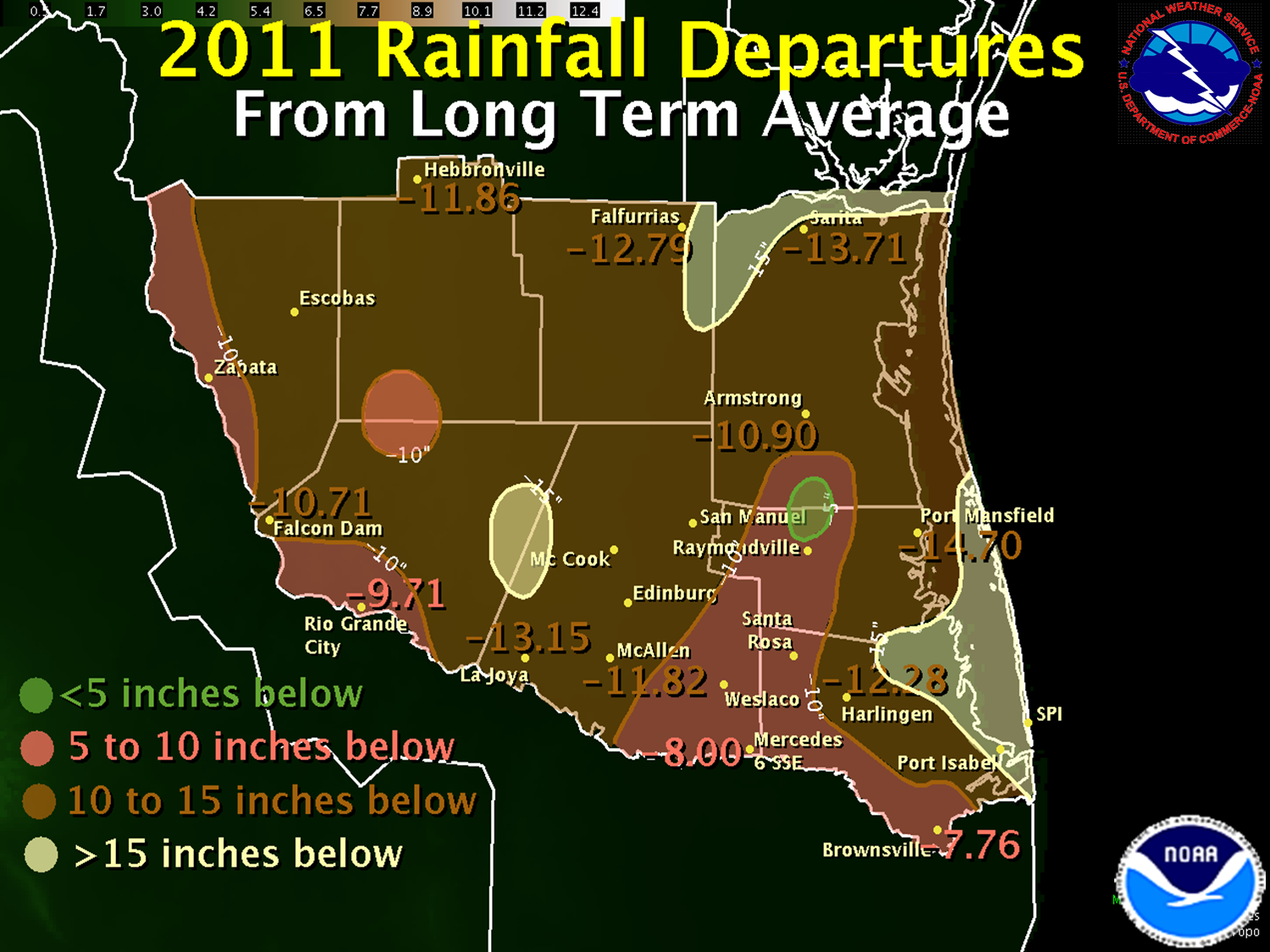
July was the perfect backdrop for many trips to the beach: Typically hot days, warm nights, and fresh breezes. Rainfall became scarce once again, but drought intensity dipped in the Lower Valley, courtesy of the nearly ten inches of rain in June, to moderate levels. The Rio Grande Plains and Ranchlands remained Severe to Extreme. Aside from some helpful storms in Hidalgo and parts of Starr County on the 3rd, the only rain fell just before the end of the month, when Tropical Storm ’Dud’ ...err Don, dissipated into a combination of dry air and wind shear on the 29th. Don provided a touch of welcome rain to eastern Cameron County, as well as an outer band of afternoon thunderstorms to the ranchlands of eastern Jim Hogg/western Brooks County. August returned sweltering heat to Deep South Texas and the Rio Grande Valley, with record to near record heat for the month, and a top ten finish for most locations for the June to August period. Brownsville broke the all time August record for the second year in a row; McAllen/Miller finished only second to August 2009. Extreme Drought expanded toward the coast as the minimal rainfall countered the approaching annual peak of long term rainfall averages. September picked up where August left off, and then some. The 2011 Hurricane Season was in full swing, and even the Gulf was open for business on Labor Day. Unfortunately, the wall of dry air and wind shear blocked Tropical Storm Lee into the Louisiana Coast. Dry air compressing on the back side of the storm brought record temperatures, as triple digit heat covered all but the immediate beaches for the first time in 2011. The cyclone churned the Gulf into high surf and tidal run up during one of the busiest beach weekends of the season. Coordinated messages from NWS and beach patrol ensured no injuries or fatalities from the surf and associated rip currents. A week later, another hopeful "threat" from Tropical Storm Nate ended without a whimper, the cyclone pressed into the Bay of Campeche before headed into Mexico – and a resurgence of hot, dry weather for the Valley. Normally the wettest month of the calendar year, September 2011 tried to take on such a personality between the 15th and 19th. Locally heavy rainfall fell near the coast on the 15th and 16th, a damaging windstorm raked Fronton (west of Roma, Starr County) on the 17th, and more than an inch of rain fell in Brownsville on the 19th. Mid month scattered rain would be overwhelmed by more dry, hot weather to close out September. McAllen/Miller airport averaged more than 100°F for afternoon high temperature! Rainfall departures from average ranging from 2 inches below in the Upper Valley to more than 5 inches below toward the coast finished off the 2011 water year in record dry style. All locations finished in the top ten driest all time, with nearly every inland location breaking all time records, some with more than 110 years of data. Drought conditions deteriorated back toward mid June levels, reaching Extreme to Exceptional across nearly the entire region by the end of September. |
||||||||||||||||||||||||||||||||||||||||||||||||||||||||||||||||||
| October to December: Hot, Dry Start; Cool, Damp Finish | ||||||||||||||||||||||||||||||||||||||||||||||||||||||||||||||||||
|
The middle of meteorological autumn (September to November) was just an extension of summer for all but the final days, when the first heat–breaking cold front put an end to the nearly six consecutive months of daytime temperatures in the 90s a few days prior to Halloween. October was largely uneventful, save for a Sunday soaking in northern Willacy and southern Kenedy County, where 2 to 4 inches of rain fell during afternoon thunderstorm clusters. The other issue was an outbreak of red tide which plagued South Padre Island for the latter half of autumn. Worst impacts were felt between October 15th and 22nd, when high counts of K. Brevis killed thousands of fish, and blitzed beachgoers and residents with aerosols that made breathing difficult. For yet another month, rainfall was well below average, ranking in the top ten driest at several locations. Longer nights allowed for cooling temperatures on many sunrises from the middle of the month through Halloween. The lowered overnight temperatures brought total average temperatures close, but still slightly above, monthly normals. November broke the string of endless summer like months. Transitional weather dominated, with little rainfall (typical of November in the long term). Periods of much below average temperatures were interspersed with much above average spells; a period of very warm days from the 13th to the 22nd (high temperatures around 90, on average) ensured another warm month on the whole. The heat was broken once and for all at the end of Thanksgiving weekend and early the following week, as a strong cold front brought gale force winds, extremely dry air, and an early morning freeze between the 27th and 29th. Afternoon humidity fell below 10 percent away from the coast on three successive afternoons, and the month ended with Exceptional Drought across all but a few pockets of the Rio Grande Valley. Meteorological winter begins in December, and 2011 was no exception. After months of recurring 90° heat, December failed to reach 90° in the Valley. While spring like 80s bookended the start, middle, and end of the month, more than a dozen days were in the 50s and 60s, and the sensible weather slipped into holiday mode – frequent steel gray overcast days, occasional drizzle and routine dewy mornings, and many days with north, rather than south, winds. The descent into coolness began with successive minor freezes December 7th and 8th, and was punctuated by the first widespread steady rains since January on December 10 and 11; between 1 and 3 inches covered most of Deep South Texas. The rain was especially welcome in western Hidalgo and eastern Starr County; in some areas, rainfall on these two days was nearly half of what had fallen the prior fourteen months!. These wetting rains, combined with later light rain and drizzle events on successive weekends through Christmas brought hints of green to the withered landscape, and put the brakes on further worsening of the drought. To Page 1 |
||||||||||||||||||||||||||||||||||||||||||||||||||||||||||||||||||

