 Chill: High and Low Temperatures across Deep South Texas shown for January 11th through 13th, 2011. Contours represent the general range of the afternoon highs each day; note the warm front helped to moderate temperatures near the coast by providing an easterly wind. |
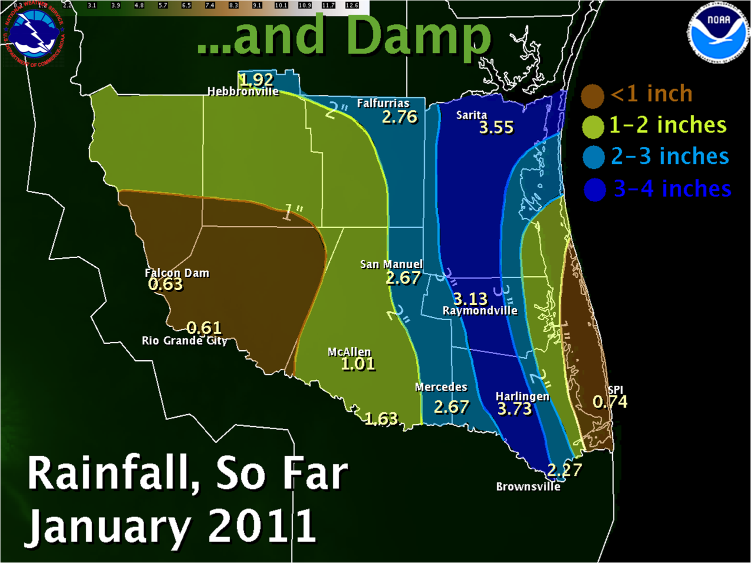 Relief: Contour map of rain totals since the start of 2011 through late morning of January 17th, 2011. |
|||||||||||||||||||||||||||||||||||||||||||||||||||||||||||||||||||||||||||||||||||||||||||||||||||||||||||||||||||||||||||||||||||||||||||||
| The Drought takes Time Out in Mid January 2011 Heavy Rainfall, Cold Drizzle A Boon to Farmers and Firefighters |
||||||||||||||||||||||||||||||||||||||||||||||||||||||||||||||||||||||||||||||||||||||||||||||||||||||||||||||||||||||||||||||||||||||||||||||
|
Overview The "front" which followed was dry yet again, and afternoon humidity tumbled into the teens along with gusty northwest winds up to 30 mph, maintaining a substantial threat for rapid fire growth along the Rio Grande. The drying pattern came to an abrupt halt on January 11th (above left), when high pressure with Arctic origins oozed south of the border, and combined with southerly flow of warmer, more humid air just above the surface to give the season’s first bona fide damp chill. Temperatures dropped into the upper 30s and 40s away from the coast on the 11th, and barely budged for three days in the heart of the Rio Grande Valley north through the Brush Country, King Ranch, and Rio Grande Highlands. Convergence set off by the contrast of milder flow near the coast and the cool air trapped inland set up an active coastal warm front, where a persistent band of light to moderate rains added up to 1 to 2 inches across the Lower Valley, eventually extending northward to the King Ranch during the afternoon of the 15th. Overnight into the early morning hours of the 16th, a vigorous upper level disturbance further activated the front, and ultimately produced a swirl of energy (bottom right) that dropped another inch or more of rainfall in Greater Brownsville and environs. Final rainfall totals showed a band of more than 3 inches fell between Brownsville and Harlingen from the 14th to the 16th. The band extends along highway 77 into the King Ranch when including rainfall from a line of thunderstorms after midnight on January 9th. While not a drought breaker by any means, the long duration rains following damp chill has temporarily stopped the rapid drying trend from so little rain combined with frequent wind and low humidity events. Unfortunately, a continued moderate to strong La Niña suggests only temporary relief, with a return to dry, warm conditions as we head into spring 2011. Stay tuned for updates to this article through January 18th.
i=Incomplete Data
|
||||||||||||||||||||||||||||||||||||||||||||||||||||||||||||||||||||||||||||||||||||||||||||||||||||||||||||||||||||||||||||||||||||||||||||||
 Daily Weather Map, 6 AM CST January 11th, showing strong high pressure with Canadian/Arctic Origins nosing southward from the northern Plains into northeastern Mexico. |
 The swirl moving across Cameron County was the core of a vigorous, but small, upper level disturbance scooting east across northern Mexico and Deep South Texas during the pre dawn hours of January 16th. Additional rains of one half to one inch likely accompanied the core. |
|||||||||||||||||||||||||||||||||||||||||||||||||||||||||||||||||||||||||||||||||||||||||||||||||||||||||||||||||||||||||||||||||||||||||||||

