National Weather Service United States Department of Commerce


Parched fields on the north side of Brownsville, May 31st, 2011
"Brown"[sic]ville, May 31st, 2011
Hottest and Driest Spring in the Lower Valley?
For some, March through May 2011 Broke Temperature, Rainfall Records

Overview: Drought surges in spring
A persistent pattern of a flat upper level ridge stretching from Baja California to the western Gulf of Mexico, aided by a similarly persistent mid latitude jet stream, enhanced the "battle" between advancing warm air from the equator and more slowly receding cooler air typical of meteorological spring (March to May). While the enhanced battlefield left several hundred dead in the wake of late month tornadoes in Joplin, Missouri and Central Oklahoma, persistent oppressive heat, humidity, wind, and haze dominated the latter half of May across the Rio Grande Valley – similar to much of April. Temperatures for the final dozen days were not just hot, they were several degrees above the late July average!

Rainfall was paltry once again, though some areas were impacted by a "severe weather season" around mid month. Aside from an early month refreshing front and the mid month unsettled conditions, the withering heat and wind during the balance of May maintained and intensified the extreme to exceptional drought. Pool levels at the Falcon International Reservoir fell steadily as water use increased for livestock and dryland irrigation. Unfortunately, the persistent wind, low humidity, and searing sunshine devastated some of the early sorghum crop while crop for livestock foraging was largely shut down. Critical to extreme fire danger persisted across many areas, particularly west of highway 281, where daily temperature above 100°F, humidity below 30 percent, and winds between 20 and 30 mph kept land managers on edge. Temperature averages in May were among the ten highest on record in many areas, with the dearth of precipitation, particularly across the Rio Grande Valley, ranking among the five to ten driest.

Mid Month Hailstorms
May is known for mild to moderate outbreaks of severe storms in Deep South Texas. 2011 was among the mildest in recent memory, in terms of the coverage and number of events. On May 12th, an approaching dry front and upper level disturbance brought the first rain in more than two months to Deep South Texas, with a relatively robust squall line racing across the King Ranch and into the Gulf north of Port Mansfield. Hangback showers and storms brought the first, and only, significant rain to the highway 83 corridor. A brief period of pleasant weather followed the front into the first half of the mid May weekend, but was quickly followed by an upper level disturbance which activated pooling moisture along the stationary front to the tune of scattered hailstorms, which moved from Zapata County through the ranchlands of northern Hidalgo and Brooks County before striking Willacy county with dime to golf ball size hail from a classic mini supercell thunderstorm.

The heat and humidity trickled in behind the warm front, and by the 18th, brutal temperatures returned. On the 20th, a spike of oppressive heat and humidity was forced by a developing dry line in the upper valley; some of the hottest apparent, or "feels like" temperatures since 2009 were realized in the Lower Valley. Temperatures soared to or just above 100°F with heat index values pushing 115°F, accompanied by blast furnace winds above 40 mph. The dry to moist contrast fueled the development of isolated strong to severe thunderstorms across ranchland of the four corners (where Starr, Hidalgo, Jim Hogg, and Brooks counties meet) which dumped hail the size of quarters (at least), torrential rains, and frequent to excessive cloud to ground lightning. The dryline–induced rains of May 20th would be the last seen through month’s end.

Just How Hot was spring?
Meteorological spring (March to May) 2011 went down as the hottest and driest since records were kept in McAllen (since 1941 and 1961) and Brownsville (since 1878). Combined average temperatures for April and May were very near what an average July/August combination would be! Other locations in Deep South Texas were not far behind in the rankings. A sampling of locations from Raymondville to Rio Grande City (each with around 100 or more years of record) indicated top ten temperature averages for the March–May and April/May period. Effectively, the summer of 2011 began in April; by the time June rolled around and conditions returned to "normal", any cooling would have to wait until October.

The following table shows preliminary rankings for temperature (monthly and seasonally) and precipitation (seasonally) for the three largest population centers in the Lower and Mid Valley. Records for Brownsville date back to 1878; Harlingen, 1911, and McAllen/Miller, 1961. For daily and monthly details, go to our local climate page.

Summary of Temperature and Precipitation Rankings for the Lower RGV
Ranking Data
Brownsville
Harlingen(coop)
McAllen (Miller)
May Avg. Temperature
82.7 (3, 83.2 in 1978)
81.4 (21, 84.1 in 1927)
83.6 (9, 85.5 in 2003)
April/May Avg. Temp.
81.6 (1, 80.8 in 2006)
80.6 (T3, 81.2 in 1927)
83.0 (1, 82.4 in 1999)
March-May Avg. Temp
78.7 (1, 78.5 in 2006)
77.7 (7, 78.9 in 1953)
80.4 (1, 79.9 in 1994)
March-May Rainfall
0.15 (1, 0.41 in 1955)
0.61 (1, 0.84 in 1998)
0.15 (2, 0.02 in 2005)
Preliminary measured and estimated May 2011 rainfall across Deep South Texas and the Rio Grande Valley (click to enlarge)
Preliminary measured (numerical values) and estimated (contours) rainfall for May, 2011.
Preliminary measured and estimated rainfall, water year to date (October 1 2010 to May 31 2011), Deep South Texas/Rio Grande Valley (click to enlarge)
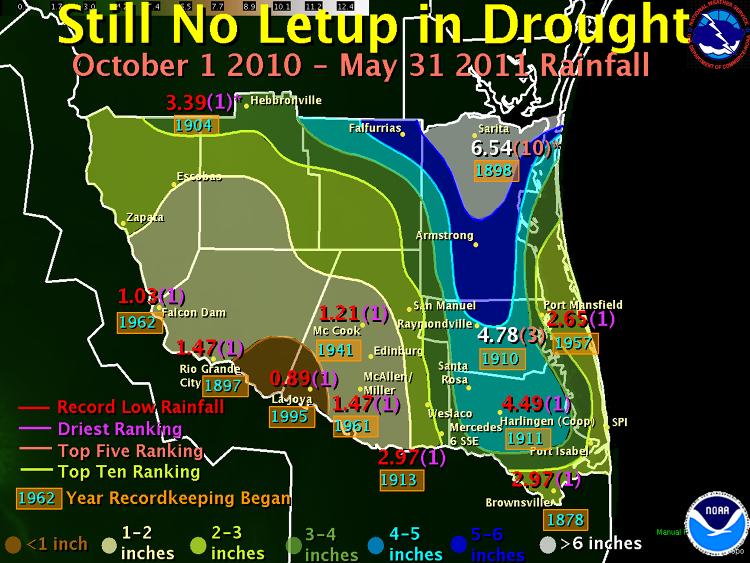
Preliminary measured (numerical values) and estimated (contours) rainfall for the water year beginning October 1, 2010 and continuing through May 31, 2011.