National Weather Service United States Department of Commerce


Rainfall across Deep South Texas/Rio Grande Valley June 22/23, 2011 (click to enlarge)
Finally!
Fast and Furious Rain Floods Poor Drainage Areas June 22/23, 2011

Overview
For a moment, at least, the drought took a short vacation. From June 22nd into June 23rd, numerous showers and thunderstorms brought tropical downpours to the Rio Grande Valley, dumping more than 6 inches in some locations and creating urban flooding from McAllen to Harlingen, mainly in the usual low lying areas and poor drainage locations. Water levels in drain clogged neighborhoods where more than 3 inches fell in less than 2 hours both on the 22nd and 23rd reached close to 3 feet, closing roads and oozing into a few properties. The torrential rains reminded residents urban drainage systems in the river delta that is the Rio Grande Valley can quickly become overwhelmed – even during an exceptional drought.

Reasons
A perfect storm of atmospheric serendipity produced the much welcomed rains. An upper level disturbance, sandwiched between a receding upper level ridge across the southwest U.S. and another ridge across Florida and the eastern Gulf of Mexico, drew deep tropical moisture northward from the Bay of Campeche and points south. Meanwhile, a vigorous upper level disturbance across the upper midwest and associated frontal zone extending from the Great Lakes southwest into North Texas helped trigger a thunderstorm complex, which initially surge into the South Texas Plains overnight on the 21st. The complex set off boundaries which sparked intense storms along the Rio Grande and into northwest Tamaulipas and northern Nuevo Leon, México, a little after daybreak on the 22nd. Boundaries from these storms, as well as leftover activity dissipating north of Jim Hogg and Brooks County, quickly activated the moisture rich environment in the Brush Country, helping to quell the large wildfire in Brooks County. By early afternoon, the combination of the disturbance, daytime heating, advancing outflow from previous storms focused on the Lower Rio Grande Valley. Intense, slow moving thunderstorms formed from Mercedes/Weslaco northeast into Santa Rosa, Harlingen, and Raymondville. The storms would gradually weaken as they edged toward Brownsville. By evening, however, weak surface low pressure helped reinvigorate the colliding boundaries, and showers and thunderstorms finally reached the coast. The low helped bring bouts of heavy rain through the night from Brownsville to South Padre Island, while the Lower Texas Gulf waters became covered in locally heavy rains overnight.

On the 23rd, the surface low parked across Cameron County. Old boundaries, a pesky upper disturbance, and some heating into very unstable air triggered another round of tropical torrents from late morning through late afternoon. These rains spared the Brush Country and Rio Grande Plains, but inundated parts of the Lower Valley with 2 to 4 more inches of rain – some which fell in the same spots on the 22nd. By the 24th, the disturbance and surface low pressure area exited stage right, taking the precipitation with them.

Impacts
Across the Lower Valley, nuisance flooding of roads, ditches, and even some properties occurred each afternoon. On the 22nd, high water closed roads for a time in Raymondville (bottom right), with locally high water in La Feria, Sebastian, Harlingen, and McAllen during the peak of the heaviest rains. An estimated 5 inches of rain flooded the Mariposa subdivision near La Feria – an area which often has poor drainage issues and suffered greatly after Hurricane Dolly. On the 23rd, more than 3 inches in Brownsville flooded roads in downtown and points west. Dozens of roads flooded in Weslaco, where more than 3 inches also fell in a short period of time. A section of Sebastian (on the Willacy/Cameron County line) with clogged drainage could not handle the second round of downpours in two days, and properties which flooded during Hurricane Dolly flooded again by mid to late afternoon. While flooding was the most common hazard, frequent cloud to ground lightning, particularly on the 22nd, caught a 400 barrel oil container on fire in Willacy County, and effects of a strike injured a woman attempting to enter her vehicle. Finally, the onset of storminess in Harlingen produced a pulse wind gust of 66 mph at Valley International Airport.

How Now, Drought?
While the torrents took the current water year (October 1st 2010 to present) out of record driest territory in the Valley, the lower rainfall in the Brush Country maintained historically record driest conditions for a bit longer. For Brownsville, water year totals rose from 2.78 to 7.71, pulling the period from 1st to 8th driest, with nearly double the prior 8 ½ month total (4.93) in two days! For Harlingen, the 4.34 inches nearly doubled the prior value, leaving 8.83 inches and pulling the period from 1st to 8th driest as well. McAllen/Miller had a sharp rise as well, with at least 3.91 inches pushing totals above 5.38 inches, moving the all time ranking to 4th or 5th driest. Other Valley climate locations showed similar rises. Still, ranking in the top ten driest after such prodigious rains indicates just how much more rain is needed to first dent, then break, the current drought.

Thanks to our Facebook followers for providing photos and information through the first big rain event of the "wet" season of 2011. Thanks also to our CoCoRaHS observers, spotters, and others who provided valuable rainfall and other information through the event.

Infrared Satellite photo and annotation, 715 AM June 22, 2011 (click to enlarge)
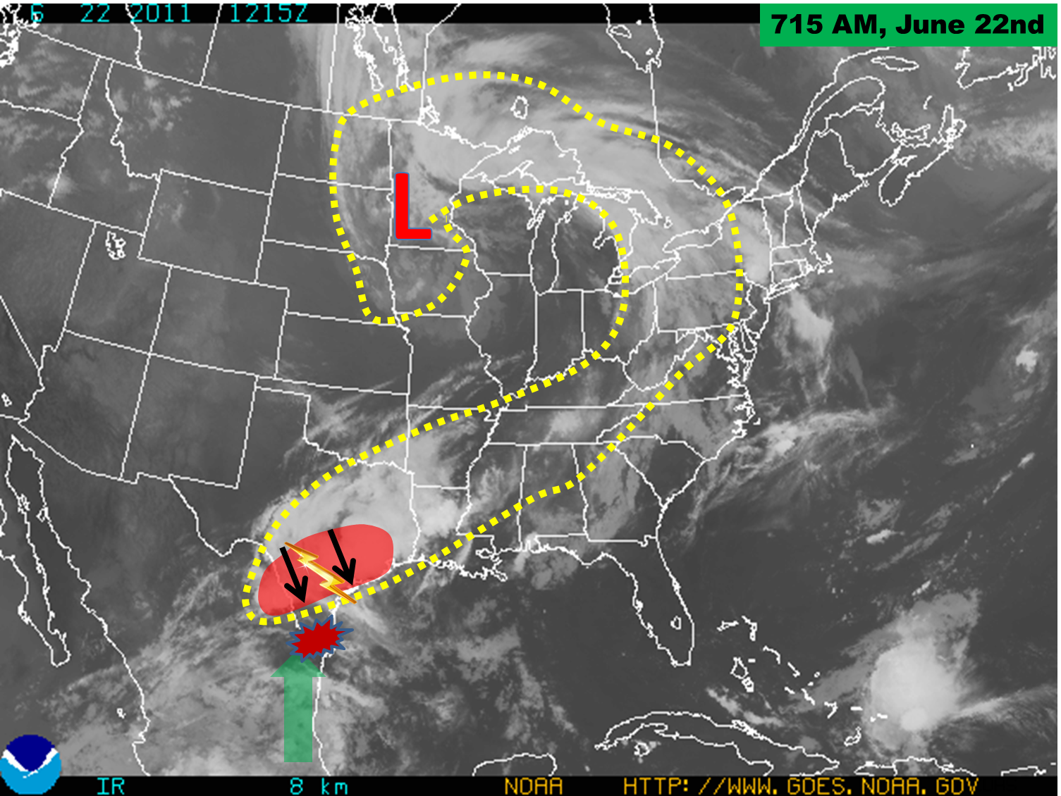
Satellite photo prior to the onset of torrential rains in Deep South Texas. The yellow dashed area shows energy boundary, stretching from the Great Lakes/Northeast U.S. southwest into central Texas. Red shaded area denotes active thunderstorm complex moving south into rich tropical moisture (green arrow).
Infrared Satellite photo and annotation, 345 PM June 22, 2011 (click to enlarge)
Satellite photo during peak of heavy rains in the Rio Grande Valley. Note the extent of activity well into Mexico; yellow dashed area shows entire energy boundary covering much of North America.

The following are preliminary rain totals from June 22nd through 23rd for Deep South Texas and the Rio Grande Valley.

 
PUBLIC INFORMATION STATEMENT
NATIONAL WEATHER SERVICE BROWNSVILLE TX
1115 AM CDT FRI JUN 24 2011

AN UPPER LEVEL LOW PRESSURE SYSTEM AND ABUNDANT TROPICAL MOISTURE 
PRODUCED WELCOME RAINS ACROSS PARCHED DEEP SOUTH TEXAS ON WEDNESDAY 
AND AGAIN ON THURSDAY. LOCALLY HEAVY RAINFALL ACROSS CERTAIN AREAS, 
REPLENISHED BADLY NEEDED SOIL MOISTURE. THE FOLLOWING ARE 2 DAY 
RAINFALL AMOUNTS FOR SELECT LOCATIONS ENDING AROUND 8 AM THIS 
MORNING. 

AIRPORTS/ASOS/AWOS/RAWS
============================
BROWNSVILLE             4.93 INCHES
SANTA ANA               3.57
MCALLEN                 3.54
LAGUNA ATASCOSA         2.06
HARLINGEN               1.97
LINN-SAN MANUEL         1.39
EDINBURG                1.15
ZAPATA                  0.63
HEBBRONVILLE            0.06  
FALFURRIAS              0.06 


NWS COOPERATIVE OBSERVERS
============================
WESLACO                 6.04 INCHES
MERCEDES                5.41
HARLINGEN               4.34
SANTA ROSA              3.94
EDINBURG                2.80
RAYMONDVILLE            2.60
ARMSTRONG               2.30
RIO GRANDE CITY         2.02
SOUTH PADRE ISLAND      1.99
LA JOYA                 1.83
MCALLEN                 1.80
PORT ISABEL             1.80
PORT MANSFIELD          1.75
ESCOBAS                 1.65
SARITA                  1.65
FALCON RESERVOIR        1.02
HEBBRONVILLE            0.20
            
COCORAHS/HYDROLOGIC GAGES/MISC
===============================
RAYMONDVILLE  5.8 E      6.43 INCHES
HARLINGEN     4.7 WSW    5.27
HARLINGEN     4.3 WSW    4.72
BROWNSVILLE   4.1 E      4.44
MISSION       1.9 ENE    4.25
BROWNSVILLE   2.2 W      4.03
BROWNSVILLE   6.4 SE     3.87  
BROWNSVILLE   1.9 ESE    3.84
BROWNSVILLE   0.1 SSE    3.68
HARLINGEN     2.6 ESE    3.40
ALAMO         1.5 NNE    3.40
RIO HONDO     4.4 NE     3.27
EDINBURG      1.1 ESE    3.18
BROWNSVILLE   4.4 NE     3.06
SAN BENITO    5.0 SSE    2.93
LOS FRESNOS   0.3 NE     2.32
BROWNSVILLE   0.7 E      1.97
RANCHO VIEJO  0.7 E      1.82
BAYVIEW       2.9 N      1.70
BROWNSVILLE   5.0 NW     1.69
LA JOYA       11.1 N     1.69 


Radar during period of heaviest rainfall, taken at around 230 PM CDT (click to enlarge)
Base reflectivity, 05° elevation, at 230 PM CDT June 22nd. Red box was for severe thunderstorm warning, triggered by similar looking storms that produced a 66 mph wind gusts an hour earlier at Valley International Airport.
Photo of urban flooding in Raymondville, June 22nd, 2011 (click to enlarge)
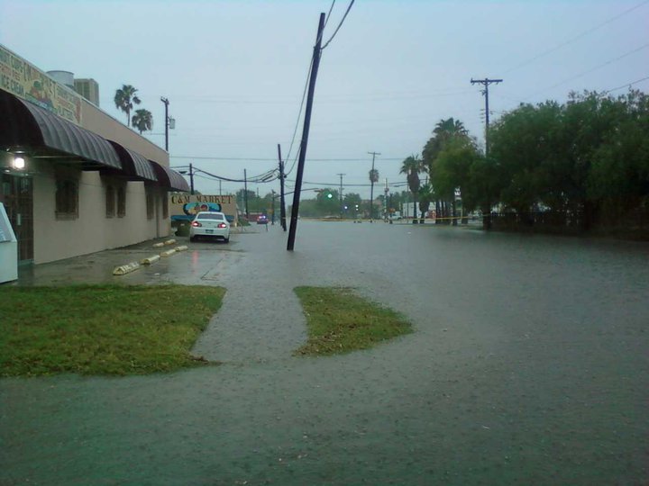
Urban flooding, 9th and Kimball in Raymondville. Courtesy of Willacy Skywarn via Facebook.