| A Review of Local Weather in 2008 |
The 2008 Hurricane Season was a busy one for the U.S., and in particular for Texas, with every named storm from Dolly through Ike making a U.S. landfall. Cristobal came very close to the N. Carolina Outer Banks, although the eye remained offshore as it moved along the coast on July 20. Dolly came ashore as a category 1 hurricane into Deep South Texas' South Padre Island on the afternoon of July 23, having just weakened from category 2 strength. Edouard made landfall on the Upper Texas Coast as a tropical storm on the morning of August 5. Tropical Storm Fay made four separate landfalls in Florida, a state record, from August 19-23. After having been a major hurricane over the Gulf of America, Gustav moved ashore near Cocodrie, LA, as a category 2 hurricane on the 1st of September. This storm prompted the first large scale evacuation of New Orleans since Katrina, as well as the first significant test of the partially repaired levee system. Hanna briefly reached hurricane strength, but spent most of its life cycle as a tropical storm, making its initial U.S. landfall near the N. Carolina-S. Carolina border during the predawn hours of September 6. Hanna quickly moved across the mid Atlantic states, crossing both the Chesapeake and Delaware Bays before passing very near New York City that evening. Hurricane Ike was the most destructive storm of the season in the U.S. making landfall as a strong category 2 hurricane on the north end of Galveston Island, TX, during the pre-dawn hours of September 13. The hurricane tracked across Galveston Bay, just east of Houston, causing significant damage to that major city. The hurricane weakened to a tropical storm over eastern TX before transitioning to extratropical status in Missouri. These extratropical remnants remained unusually vigorous and caused hurricane force wind gusts across the Ohio Valley on the afternoon of September 14. Of these seven systems, Tropical Storm Fay was the only one to directly impact the local area. However, Gustav and Ike both caused significant surf, beach erosion and coastal flooding along our coastline. Finally, remnant moisture from Paloma produced locally heavy rains totaling over 3 inches in the Tallahassee area when it came ashore in mid November, five days after plowing into Cuba as a major hurricane. In addition to the three tropical systems, weather highlights include significant severe weather events on February 17-18th, February 26th, March 7th, and October 8th; a major flood event on February 21st-22nd; non-tropical coastal flooding on October 24th; and finally a non-thunderstorm wind damage and flood event on December 11th. All of these events will be discussed in greater detail below.
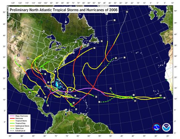
Figure 1. Preliminary storm tracks for the 2008 Atlantic Hurricane Season.
As can be seen in Figure 2 (below), the year started with a cold snap after a very warm December 2007. Another significant warm-up followed the 2nd week of the year followed by generally colder than normal conditions for the remainder of the month. Temperatures were generally warmer than normal during February with a few cold episodes. March had a warm spell mid month, but was generally colder than normal. The last freeze of the year occurred on the 25th when the mercury dropped to 26 degrees. April was generally warmer than normal, but a sharp cold spell mid month sent temps tumbling to near freezing on the morning of the 16th. May was generally warmer than normal after the first week. The first 90-degree day occurred on the 9th. June started out hot, but was generally a bit cooler than normal over the last half of the month. July was near normal and August was a bit cooler than normal with all of the clouds and rain that fell that month. September started out warm and humid, but summer ended abruptly late in the month with the mercury dropping all the way to 50 degrees on the morning of the 25th. Cooler than normal temperatures over the last half of September continued into early October, followed by a week and a half of above normal temps. A sharp cold snap late in the month brought winter-like temperatures to the area. The first freeze of the season occurred on the 29th. The 29-degree reading that morning was the coldest ever recorded in the month of October. The cold weather persisted for most of November. Subfreezing temperatures were recorded at the airport on six consecutive days leading up to Thanksgiving. The month was nearly five degrees colder than normal and over a degree colder on average than the month of December. November was tied for the 7th coldest on record. The cold weather continued through the first week or so of December, before an extended period of above normal temperatures closed out the year and continued into early January 2009. Temperatures in Tallahassee for the year ranged from a maximum of 98 degrees on June 7th and 8th, July 19th, and August 6th, to a minimum of just 25 degrees on January 3rd, February 14th and November 19th. The last time the mercury failed to drop below 25 degrees in a calendar year in Tallahassee was way back in 1953. The average temperature for the year in Tallahassee was 67.6 degrees, which was 0.4 degrees below normal.
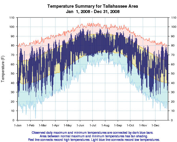
Figure 2. Temperatures in Tallahassee during the year 2008.
Figure 3 (below) shows that Tallahassee started out the year on a dry note over the first seven weeks of the year. The first of several notable rainfalls during the year occurred in late February when a two day rain event produced a widespread swath of 6-8 inch rainfall totals across the forecast area. This event put Tallahassee in a surplus situation in terms of annual rainfall. Rainfall in the first week of March kept us on the plus side. However, a three week dry spell set in after that with only 0.09 inches of rain falling at the airport over the final 20 days of the month. The ensuing deficit would continue over the next several months, although a heavy rain event on April 5 almost erased it. The remainder of April and first half of May were typically dry. Rainfall for late May and much of June was below normal. A brief rainy period in late June and early July cut into the deficit, but another dry period followed through the last 2/3 of July and the first part of August, unusual for midsummer. The flood gates opened, literally, during the month of August with Tropical Storm Fay alone dumping one to two feet of rain on the Florida Big Bend and adjacent portions of Southwest Georgia. This rainfall completely erased the deficit for the year. August 2008 will go into the books as the wettest on record. The 16.52 inches of rain that fell during the month exceeded the previous record set in 1977 by over 3/4 of an inch. After Fay's deluge, a very dry period commenced. From August 27 through October 6, only 1.30 inches of rain fell at the Tallahassee airport. September was the ninth driest on record. Above normal rainfall fell during the remainder of October and November and the deficit was nearly erased once again by December 11th. The spigot shut off once again after that with just 0.04 inches of rain falling over the final 20 days of the year. The wettest calendar day of the year was August 23rd, when 6.30 inches of rain fell. The wettest 24-hour period was the 8.09 inches from August 22nd-23rd. The driest month was September with just 1.29 inches of rain, but December was a close second with only 1.39 inches of rain, tied for ninth driest on record. The annual rainfall total for 2008 was 60.39 inches in The Capital City, which is just 2.82 inches below normal.
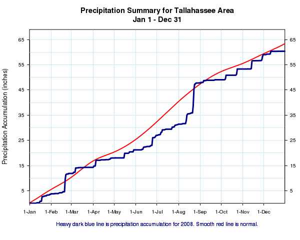
Figure 3. Rainfall in Tallahassee during the year 2008.
Following are some of the weather highlights that occurred in the NWS Tallahassee County Warning & Forecast Area in 2008.
January - Generally Cool & Dry with a Warm 2nd Week
Temperatures averaged just a half degree below normal during January. A cold snap in the first few days of the month produced what turned out to be the coldest days of the year in Tallahassee. The maximum temperature on the 2nd was just 42 degrees, the coldest daytime high of any day in the year. The low the next morning of 25 degrees tied for the coldest temperature of 2008. The two days (2nd and 3rd) had an average temperature of 36 degrees making them the coldest of the year. An warm spell set in the 2nd week of the month with the mercury reaching or exceeding 70 degrees on eight consecutive days. Temperatures were then generally cooler than normal the rest of the month. There were 11 mornings when temps dipped to the freezing point or lower, which is normal. January was a drier than normal month, with just shy of 2/3 of the normal rainfall. Thunderstorms were reported on just one day during the entire month.
February - Warmer than Normal with a Stormy 2nd Half
February was nearly a degree warmer than normal with long periods of warm temperatures interrupted by brief cold snaps. There were 20 days during the month where the temperature exceeded 70 degrees and nine days with upper 70s. There were eight mornings with freezing temperatures at Tallahassee. The low of 25 degrees on the 14th tied for the coldest temperature observed during the calendar year. There were several significant weather events in the second half of the month. Beginning Sunday afternoon, the 17th, and continuing into the early morning hours of Monday, the 18th, the NWS Weather Forecast Office in Tallahassee issued 34 warnings. These included 9 tornado, 17 severe thunderstorm, and 8 special marine warnings. Two tornadoes were confirmed by NWS survey crews. One tracked across northwest Coffee County, AL. A second affected northern Gadsden County, FL , and Decatur and Grady Counties in GA. Fortunately, there were no fatalities associated with this severe weather episode. However, two people were injured in the Tallahassee County Warning Area: one on Interstate 10 in Gadsden County, and another in a trailer home in Grady County. There were 46 other injuries reported across Central AL and northern GA. Additional details can be found on the event web page. Just a few days later, thunderstorms with heavy rains trained across the Florida Panhandle and Big Bend into Southwest Georgia during the evening and overnight hours of the 21st-22nd, north of a stalled warm front. Widespread 5-10 inch rainfall totals were reported. More heavy rains followed the next day ahead of a cold front with 2-3 more inches of rain falling. Widespread flooding was reported in Bay County and surrounding areas, with riverine flooding to follow in the days to come across the region. For additional information on this flooding, see our event web page. Again, less than a week later, a third significant weather event affect the region as a quick moving pre-frontal squall line swept across the NWS Tallahassee County Warning Area during the mid morning to early afternoon hours of the 26th. A total of 16 warnings were issued, including 14 severe thunderstorm warnings, one tornado warning and one special marine warning. There were a couple of hail reports. However, wind damage reports were widespread, mainly in the form of downed trees and power lines that were felled by 35 to 45 mph wind gusts, which is well below severe limits. This is likely due to the flooding heavy rains that fell less than a week earlier that loosened soils, allowing trees and utility poles to topple over much more easily than if the ground was more solid. The most significant wind damage occurred in Thomas County, GA, where an NWS survey crew estimated 70 to 75 mph straight line winds. Details on this event be found on the event web page.
March - Generally Dry with Big Bend Tornadoes
March, typically a stormy month, was very dry once again in 2008, with one significant severe weather episode. A brief, but extensive severe weather episode occurred across the Florida Big Bend during the morning of the 7th. There were widespread reports of straight line wind damage across the region, with three tornadoes reported, two confirmed by NWS survey teams. One of the confirmed tornadoes affected the Capitola area of eastern Leon County. The other came ashore into Keaton Beach from the Gulf of America. There was also some urban street flooding in Tallahassee, followed by some riverine flooding in the ensuing days. Additional details on this event can be found on the event web page. This event represents the only significant rainfall in Tallahassee during what is normally a fairly wet month. The 2.41 inches of rain that fell was just over 1/3 of normal. Over the final 20 days of the month, only 0.09 inches of rain was recorded at the airport. Temperatures were nearly two degrees colder than normal during the month in Tallahassee. There were three mornings when temps dipped to the freezing point or lower, which is normal. The last freeze of the season occurred on the 26th.
April - Warm Start with a Mid-Month Cold Snap
Overall, April temperatures and rainfall were both close to normal in Tallahassee. The first 12 days of the month saw above normal temperatures, but then an unseasonably cold period set in around mid month with winter-like temperatures. There were three consecutive mornings with lows in the 30s from the 15th through the 17th. The low of 37 on the 15th tied the record for the date, while the 33 degree reading established on new record for the 16th. Temperatures were near normal for the latter part of the month. Nearly 2/3 of the observed rainfall for the month was observed on the 5th, with 2.20 inches of rain falling in Tallahassee.
May - Generally Dry with Above Normal Temperatures
Long stretches of dry weather in May is not unusual and that is what occurred over the first half of the month. Only 0.05 inches of rain fell through the 15th. A few rain events in the second half of the month brought the monthly total to about 2/3 of normal. Two thirds of the days in May were warmer than normal with 12 days reaching 90 degrees or better. However, the general dryness of the airmasses in place during the month allowed for some large diurnal variations in temperature. For example, a record low of 47 degrees was tied on the 13th. The afternoon high soared to 88 degrees, a 41-degree rise.
June - Hot & Dry Start - Milder and Wetter 2nd Half
One of the hottest stretches of the summer occurred in early June. Each of the first 10 days saw high temps in the mid to upper 90s. The 98-degree readings recorded on the 7th and 8th wound up being the highest observed during the year. Rainfall on the 10th ended an 11-day rain-free stretch, very unusual for high summer. Routine rains commenced for the remainder of the month with the final total coming up just over an inch below normal. Much of this came on the 25th when 3.08 inches of rain was measured at the airport.
July - Drier than Normal with Little Extreme Heat
Rainfall for the month of July was just over half of normal despite fairly regular rains. No single day recorded in excess of an inch of rain with the greatest 24-hour total just 0.92 inches on the 9th. Only five days saw temperatures in excess of 94 degrees during the month with the maximum temperature of the year of 98 degrees tied on the 19th.
August - Wettest on Record Thanks to Tropical Storm Fay
August will go into the books as the wettest on record, thanks in large part to the deluge of rain the area received from Tropical Storm Fay. Fay will go down in history as one of the most prolific rain producers in our area. Rainfall totals exceeding 20 inches in some locations created record floods on some area rivers and flooding in Tallahassee and surrounding cities the likes of which has not been seen in many years. The storm also brought minor storm surge flooding to parts of the Big Bend coastline and spawned several tornadoes on the 23rd and 25th. Additional details on Tropical Storm Fay can be found in the event web page. The 16.52 inches of rain that fell during the month broke the old record of 15.73 inches set in 1977. Daily rainfall records were set on the 21st, 22nd and 23rd. The high temperature for the month was 98 degrees on the 6th which tied for highest temperature observed during the year. The lowest temperature for the month was 62 degrees on the 10th which established a new record low for the date.
September - Gustav and Ike Impacts - Otherwise Very Dry
Hurricanes Gustav and Ike made landfall well west of the area during September. However, both were powerful enough to cause peripheral, mainly coastal and marine impacts across the local area. Hurricane Gustav caused storm tides of 3 to 5 feet along the Panhandle coast on the 1st and 2nd, which caused coastal flooding and minor beach erosion. Several roads and homes in coastal Gulf, Wakulla and Franklin Counties were affected. Sustained tropical storm force winds were measured over the marine area. Additional details on the local impacts of Gustav can be found in our post tropical cyclone report. Hurricane Ike was much further south as it moved across the eastern Gulf of America, but it produced storm surges o 2 to 3 feet along the Big Bend and Panhandle coast with storm tides of 4 to 6 feet. Minor beach erosion and high surf occurred on the 11th along the coast from Walton to Franklin Counties. Neither of these storms brought significant rainfall to the area and the month was quite dry as a whole. Total rainfall in Tallahassee was just 1.29 inches, which was just a quarter of normal making this September the 9th driest on record. A welcome cool down at the end of the month brought relief from summer's heat and humidity. Morning lows were in the lower 50s from the 25th through 28th.
October - Two Storms - Late Month Cold Snap
Several lines of strong to severe thunderstorms formed ahead of a cold front and strong low pressure system over southern Alabama and the Florida Panhandle during the morning of the 8th, then moved into portions of southeast Alabama, southwest Georgia, and the Florida Big Bend in the afternoon. There were eight confirmed tornadoes, six rated EF0 and two EF1, as well as a few reports of straight line wind damage. Additional details on this event can be found in the event web page. An extratropical low pressure system brought some minor beach erosion to parts of the coastline in Walton, Franklin and Wakulla Counties on the 24th. Both this storm and the one that spawned the tornadoes each brought significant rains to the area in a month that is typically dry. The 4.26 inches of rain that fell in Tallahassee in October was about an inch above normal. Most of the 2nd half of the month was cooler than normal, but a sharp cold snap at month's end brought winter-like temperatures to the area. The high temperature on the 28th was only 59 degrees. This set up a very cold night that saw the mercury drop all the way to 29 degrees, the coldest reading ever observed in Tallahassee in the month of October. The previous record was 30 degrees, set most recently in 1993.
November - Colder & Wetter than Normal
November was the 7th coldest on record thanks mainly to a persistent period of cold weather from the 16th through the 26th. Temperatures averaged 10 or more degrees below normal on 10 days during this stretch. There were seven freezes recorded at the airport, six of them coming on consecutive mornings from the 18th through the 23rd, Thanksgiving Day. The coldest temperature of the month was 25 degrees on the 19th. This broke the old record for that date of 29 degrees set in 1990. The monthly average temperature of 55.5 degrees was nearly five degrees colder than normal. There were two significant rainfall events during the month with long dry stretches in between. Over three inches of rain fell mid month as the remnant moisture from what was once Hurricane Paloma surged into the Big Bend. Another couple of inches of rain fell on the final two days of the month. The 5.68 inches of rain in Tallahassee was nearly 50 percent above normal.
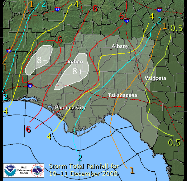
December - Cool Start then Dry and Very Warm - Heavy Rain & Wind Event on 10-11th
A storm system during the 2nd week of December brought flooding rains to much of the forecast area, particularly areas north and west of Tallahassee. Rainfall totals exceeded 8 inches over parts of Southeast Alabama, Southwest Georgia and the Florida Panhandle. A rainfall total contoured graphic is available for this event. In addition to the very heavy rains, gusty winds accompanied showers along the cold front as it swept across the area. Heavy rains loosened soils and wind gusts in excess of 40 mph resulted in widespread wind damage. December started out cold, but most of the month after the 8th was unusually warm. The temperature reached 70 or better on 19 days during the month including 75 degrees on Christmas Day. The warmest temperature for the month was 80 degrees on the 18th. December wound up being about a degree warmer than November was with the average monthly temperature coming in nearly three degrees above normal.
Severe Weather
Typically, this part of the country sees a peak in severe weather activity during the spring months with a secondary maximum in November. Through summer, isolated severe storms are possible on almost any day, although large outbreaks are much less common. Occasionally severe weather occurs in the winter months, and some of these can be major outbreaks. 2008 generally followed these trends. Monthly summaries of severe weather occurrences in 2008 are available here.
Previous Years
Reviews of local weather in 2007, 2006, 2005, 2004, 2003, 2002, 2001 and 2000 are also available.
National Weather in 2008
NCDC provides a review of annual weather across the nation in 2008 including significant events.

