| Cooperative Observer Program |
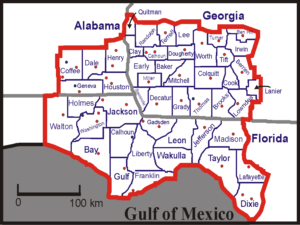
The location of our climate and hourly precipitation sites are indicated by red circles. Our river gauge sites are shown as blue squares.
This page is presented to honor the National Weather Service's Cooperative Weather Observers.
The 11,700 Cooperative Weather Observers across the United States, including those in the Weather Service Forecast Office, Tallahassee area, net the public more per dollar expended than any other government service in the world. Cooperative Weather Observers donate more than a million hours each year to obtain weather data. Observers provide the precious stream of weather information that we need to forecast the weather, issue weather warnings, and record the climates of the United States.
Thomas Jefferson envisioned a nationwide network of weather observers as early as 1797, when he outlined a plan for providing weather instruments to someone in every county of Virginia, so that a regular statewide record might be maintained.
A plan of this kind was not established until almost 100 years later when, in 1891, the Weather Bureau was charged with the task of "taking such meteorological observations as may be necessary to establish and record the climatic conditions of the United States." In compliance with these directions, the Weather Bureau relied heavily, as it does to this day, on voluntary Cooperative Observers.
Cooperative Weather Observers come from all walks of life; they may be farmers, ranchers, lawyers, storekeepers, ministers, teachers, construction workers, and retirees. Organizations such as radio and television stations, schools, and public utilities are also examples of places that may maintain a Cooperative Weather Station.
To learn more about the Cooperative Observer Program, click here.
On behalf of the National Weather Service personnel in Tallahassee we would like to say THANK YOU to all of our cooperative observers!
| Cooperative Weather Stations |
|
|
|
|
|
|
|
|---|---|---|---|---|---|
| 01-0008 | Abbeville, Al | Henry | 05/01/98 | F/P, S | B |
| 01-2377 | Dothan, Al | Houston | 03/01/72 | F/P | B |
| 01-2675 | Enterprise, Al | Coffee | 10/01/77 | F/P, M, S | AB |
| 01-3251 | Geneva, Al | Geneva | 05/01/64 | M, S, | A |
| 01-3761 | Headland, Al | Henry | 04/01/50 | S | AB |
| 01-5875 | Newton, Al | Dale | 05/12/54 | W | B |
| 08-0211 | Apalachicola, Fl | Franklin | 10/01/95 | M, S | AB |
| 08-1388 | Caryville, Fl | Washington | 02/01/96 | S, W | B |
| 08-1544 | Chipley 1W, Fl | Washington | 03/25/95 | M, S | AB |
| 08-2008 | Cross City 2WNW | Dixie | 03/01/65 | F/P, M, S | AB |
| 08-2220 | DeFuniak Springs, Fl | Walton | 07/25/90 | M, S | A |
| 08-2391 | Dowling Park 1W, Fl | Lafayette | 06/01/72 | F/P, S | B |
| 08-3538 | Graceville 1SW, Fl | Jackson | 07/21/87 | F/P | B |
| 08-6842 | Madison, Fl | Madison | 11/01/94 | M, S | A |
| 08-5377 | Marianna, 7NE, Fl | Jackson | 07/01/74 | M, S | C |
| 08-5539 | Mayo, Fl | Lafayette | 04/01/71 | M,S | A |
| 08-5879 | Monticello 3W, Fl | Jefferson | 02/01/64 | F/P, M, S | AB |
| 08-6842 | Panama City 5NE, Fl | Bay | 12/01/71 | F/P, M, S | AB |
| 08-7025 | Perry, Fl | Taylor | 01/01/57 | M, S | A |
| 08-7429 | Quincy 3SSW, Fl | Gadsden | 04/01/64 | M, S | AB |
| 08-8565 | Steinhatchee 6ENE, Fl | Dixie | 04/01/62 | M, S | A |
| 08-9415 | Wausau, Fl | Washington | 04/23/72 | F/P | B |
| 08-9566 | Wewahitchka, Fl | Gulf | 07/01/77 | M, S | A |
| 08-9795 | Woodruff Dam, Fl | Gadsden | 06/10/52 | F/P | B |
| 09-0140 | Albany 3SE, Ga | Dougherty | 10/01/95 | M, S | AB |
| 09-0406 | Ashburn | Turner | 02/01/80 | M, S | A |
| 09-0979 | Blakely, Ga | Early | 12/03/99 | M, S | A |
| 09-1463 | Cairo 3Se, Ga | Grady | 05/01/88 | M, S | B |
| 09-1500 | Camilla 3SE, Ga | Mitchell | 02/01/60 | M, S | AB |
| 09-2153 | Colquitt 2W, Ga | Miller | 03/01/63 | M, S | A |
| 09-2450 | Cuthbert, Ga | Randolf | 04/01/45 | M, S | A |
| 09-3028 | Edison, Ga | Calhoun | 08/01/82 | F/P | B |
| 09-6087 | Moultrie 2ESE, Ga | Colquitt | 01/01/54 | M, S | A |
| 09-6244 | Nashville 4N, Ga | Berrien | 12/01/87 | M, S | A |
| 09-8666 | Thomasville 3NE, Ga | Thomas | 06/01/68 | M, S | A |
| 09-8703 | Tifton Exp Station, Ga | Tift | 01/01/57 | M, S | AB |
| 09-8974 | Valdosta, Ga | Lowndes | 04/24/97 | F/P | B |
| Stations in the table above that are shaded and in italics have been in service for at least 40 years! |
Equipment (C) Cotton Region Shelter, (S) Standard 8" Rain Gauge, (M) Max. Min Digital Display, (F/P) Fisher Porter Rain Gauge, (TB) Tipping Bucket, (W) Wire Weight Gauge, (U) Universal Rain Gauge
Networks
(A) The "a" network is the basic climatic network of the NWS. Data are used to describe the climate of the U.S. The network is based on a grid system (25 statute miles by 25 statute miles) with one station per grid box. At a minimum, "a" network stations must observer 24-hour precipitation totals. Many also report maximum and minimum temperatures.
(B) Cooperative stations are placed in the "b" network if their observations are used primarily to support NWS hydrologic programs, such as flood forecasting, hydrologic planning and water supply. Stations nearly always report 24-hour precipitation, and many include river stage or lake level. A few report maximum and minimum temperatures and the water equivalent of snow on the ground. A few stations record evaporation, and soil temperature.
(AB) Cooperative stations that support both the climatological and hydrological programs of the NWS are referred to as being in the "ab" network. They generally have the responsibilities of "a" and "b" network stations combined.
(C) Cooperative stations are placed in the "c" network if they support meteorological programs of the NWS, such as the issuance of warnings, forecasts and public service. These stations maintain the same type of observations and equipment that the other networks do.

