Tallahassee, FL
Weather Forecast Office
| Coastal Flood Monitor for Florida Panhandle and Florida Big Bend |
|
This webpage depicts current water levels across selected areas of the Florida Panhandle and Florida Big Bend. Water levels appearing on this page are shown relative to the North American Vertical Datum 1988 (NAVD88). Datum conversion charts can be found on each individual gage page. For more information on datums, or how to make an adjustment to a level of your choice, please visit this website: tidesandcurrents.noaa.gov/datum_options.html. To see water levels within a particular county, click on the link below. Note that each gage appearing on this page has four categories used to describe general impacts during times of high water. Details on specific impacts can be found by clicking on each individual graph. |
| Bay_County/Gulf County | Gulf/Franklin County |
| Wakulla County | Jefferson County |
| Taylor County | Dixie County |
| Action Stage | Should water levels continue rising, preparations to protect property should begin |
| Minor Flood | Minimal or no property damage. Flooding of low lying roads near the coast. |
| Moderate Flood | Some inundation of structures and flooding roads. Evacuation of people or property to higher elevations possible |
| Major Flood | Extensive inundation of structures in roads in the area. Evacuations of people or transfer or property to higher elevations likely. |
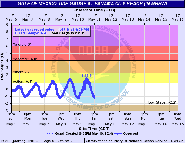 PCBF1 - Gulf of America - Panama City Beach, Florida |
 PACF1 - Gulf of America - Panama City, Florida (Marina) |
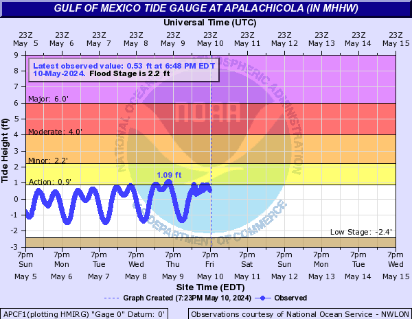 APCF1 - Gulf of America - Apalachicola, Florida |
 CTMF1 - Ochlockonee River at US 319 |
| CTMF1 - Ochlockonee River at US 319 |
 SHPF1 - Shell Point, Florida |
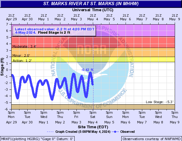 MRKF1 - Saint Marks River at Saint Marks, Florida |
|
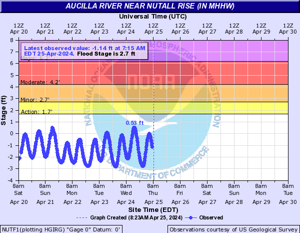 NUTF1 - Aucilla River at Nutall Rise, Florida |
 SUWF1 - Suwannee River Entrance |
Current Hazards
Hazardous Weather Outlook
National Outlook
Rip Current Risk
Local Storm Reports (Text)
Local Storm Reports (Map)
Submit a Storm Report
Radar Imagery
National
Florida Panhandle (EVX)
Southwest Alabama (EOX)
Tallahassee (TLH)
Valdosta (VAX)
Current Weather
Observations (Map)
Observations (Text)
Observed Precipitation
Rivers and Lakes
Satellite Images
Upper Air Sounding
Forecasts
Aviation Weather
Fire Weather
Forecast Discussion
Forecast Text Products
Hydrology
Local Model Data
Marine Weather
Tropical Weather
Climate
Climate Text Products
Climate Graphs
CoCoRAHS
Drought
Local Data and Records
ENSO
Tropical Cyclone Reports
US Dept of Commerce
National Oceanic and Atmospheric Administration
National Weather Service
Tallahassee, FL
1017 Academic Way
FSU, Love Bldg, 4th Floor
Tallahassee, FL 32306-4509
850-942-8833 (person) or 850-942-8851 (recording)
Comments? Questions? Please Contact Us.

