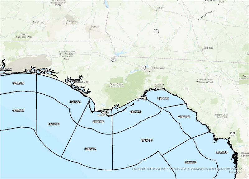
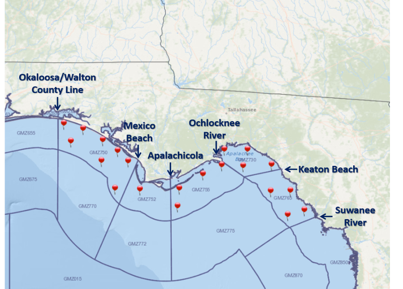
For a graphical forecast, visit weather.gov/beach/tae or see the county based surf zone forecast below:
Detailed Surf Zone Forecast
600
FZUS52 KTAE 142339
SRFTAE
Surf Zone Forecast
National Weather Service Tallahassee FL
739 PM EDT Mon Apr 14 2025
FLZ108-150800-
South Walton-
Including the beaches of Sandestin, Santa Rosa Beach,
and Turquoise Beach
639 PM CDT Mon Apr 14 2025
.TUESDAY...
Rip Current Risk............Moderate.
Surf Height.................Around 1 foot.
UV Index**..................Very High.
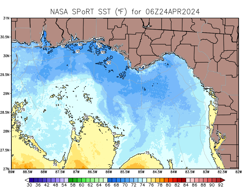
Water Temperature...........71 degrees.
Weather.....................Mostly sunny.
High Temperature............In the mid 70s.
Winds.......................West winds around 15 mph.
Tides...
Panama City..............High at 10:56 AM CDT.
Sunrise.....................7:17 AM.
Sunset......................8:12 PM.
.WEDNESDAY...
Rip Current Risk............Moderate.
Surf Height.................Around 2 feet.
Weather.....................Sunny.
High Temperature............In the lower 70s.
Winds.......................Northeast winds around 15 mph, becoming
north around 5 mph in the afternoon.
Tides...
Panama City..............High at 11:38 AM CDT.
Sunrise.....................7:16 AM.
Sunset......................8:13 PM.
.THURSDAY...Moderate rip current risk*. Surf height around 1 foot.
Sunny. Highs in the lower 70s. East winds around 10 mph.
.FRIDAY...Moderate rip current risk*. Sunny. Highs in the mid 70s.
Southeast winds around 15 mph.
.SATURDAY...Mostly sunny. Highs in the mid 70s. Southeast winds
around 10 mph.
&&
Rip Current Risk Category
* Low Risk - The risk for rip currents is low, however,
life-threatening rip currents often occur in the vicinity of groins,
jetties, reefs, and piers.
* Moderate Risk - Life-threatening rip currents are possible in the
surf zone.
* High Risk - Life-threatening rip currents are likely in the surf
zone.
** For lightning, waterspout, and UV definitions see:
https://www.weather.gov/beach/tae
$$
FLZ112-150800-
Coastal Bay-
Including the beaches of Panama City Beach and Magnolia Beach
639 PM CDT Mon Apr 14 2025
.TUESDAY...
Rip Current Risk............High.
Surf Height.................Around 3 feet.
UV Index**..................Very High.
Water Temperature...........71 degrees.
Weather.....................Mostly sunny.
High Temperature............In the mid 70s.
Winds.......................West winds around 15 mph.
Tides...
Panama City..............High at 10:56 AM CDT.
Sunrise.....................7:15 AM.
Sunset......................8:10 PM.
.WEDNESDAY...
Rip Current Risk............Moderate.
Surf Height.................Around 2 feet.
Weather.....................Sunny.
High Temperature............In the mid 70s.
Winds.......................North winds around 15 mph, diminishing
to around 5 mph in the afternoon.
Tides...
Panama City..............High at 11:38 AM CDT.
Sunrise.....................7:14 AM.
Sunset......................8:11 PM.
.THURSDAY...Moderate rip current risk*. Surf height around 1 foot.
Sunny. Highs in the lower 70s. East winds around 10 mph.
.FRIDAY...Moderate rip current risk*. Sunny. Highs in the mid 70s.
Southeast winds around 15 mph.
.SATURDAY...Mostly sunny. Highs in the mid 70s. Southeast winds
around 10 mph.
&&
Rip Current Risk Category
* Low Risk - The risk for rip currents is low, however,
life-threatening rip currents often occur in the vicinity of groins,
jetties, reefs, and piers.
* Moderate Risk - Life-threatening rip currents are possible in the
surf zone.
* High Risk - Life-threatening rip currents are likely in the surf
zone.
** For lightning, waterspout, and UV definitions see:
https://www.weather.gov/beach/tae
$$
FLZ114-150800-
Coastal Gulf-
Including the beaches of Saint Joe Beach
739 PM EDT Mon Apr 14 2025 /639 PM CDT Mon Apr 14 2025/
.TUESDAY...
Rip Current Risk...
W Facing Beaches.........Moderate.
S Facing Beaches.........Moderate.
State Park Beaches.......High.
Surf Height...
W Facing Beaches.........Around 1 foot.
S Facing Beaches.........Around 1 foot.
State Park Beaches.......Around 3 feet.
UV Index**..................Very High.
Water Temperature...........70 degrees.
Weather.....................Mostly sunny.
High Temperature............In the mid 70s.
Winds.......................West winds 15 to 20 mph.
Tides...
Apalachicola.............High at 07:32 AM EDT.
Low at 11:37 AM EDT.
High at 04:40 PM EDT.
Sunrise.....................7:14 AM.
Sunset......................8:08 PM.
.WEDNESDAY...
Rip Current Risk...
W Facing Beaches.........Moderate.
S Facing Beaches.........Moderate.
State Park Beaches.......High.
Surf Height...
W Facing Beaches.........Around 1 foot.
S Facing Beaches.........Around 1 foot.
State Park Beaches.......Around 2 feet.
Weather.....................Sunny.
High Temperature............In the mid 70s.
Winds.......................North winds around 15 mph, diminishing
to around 5 mph in the afternoon.
Tides...
Apalachicola.............High at 08:29 AM EDT.
Low at 12:14 PM EDT.
High at 05:08 PM EDT.
Sunrise.....................7:13 AM.
Sunset......................8:09 PM.
.THURSDAY...Moderate rip current risk*. Surf height around 1 foot.
Sunny. Highs in the lower 70s. East winds around 10 mph.
.FRIDAY...High rip current risk*. Sunny. Highs in the mid 70s.
Southeast winds around 15 mph.
.SATURDAY...Mostly sunny. Highs in the mid 70s. Southeast winds
around 10 mph.
&&
Rip Current Risk Category
* Low Risk - The risk for rip currents is low, however,
life-threatening rip currents often occur in the vicinity of groins,
jetties, reefs, and piers.
* Moderate Risk - Life-threatening rip currents are possible in the
surf zone.
* High Risk - Life-threatening rip currents are likely in the surf
zone.
** For lightning, waterspout, and UV definitions see:
https://www.weather.gov/beach/tae
$$
FLZ115-150800-
Coastal Franklin-
Including the beaches of Apalachicola
739 PM EDT Mon Apr 14 2025
.TUESDAY...
Rip Current Risk............Moderate.
Surf Height.................Around 1 foot.
UV Index**..................Very High.
Water Temperature...........69 degrees.
Weather.....................Mostly sunny.
High Temperature............In the mid 70s.
Winds.......................West winds around 15 mph.
Tides...
Apalachicola.............High at 07:32 AM EDT.
Low at 11:37 AM EDT.
High at 04:40 PM EDT.
Sunrise.....................7:13 AM.
Sunset......................8:06 PM.
.WEDNESDAY...
Rip Current Risk............Moderate.
Surf Height.................Around 2 feet.
Weather.....................Sunny.
High Temperature............In the lower 70s.
Winds.......................North winds around 15 mph, becoming
northeast around 5 mph in the
afternoon.
Tides...
Apalachicola.............High at 08:29 AM EDT.
Low at 12:14 PM EDT.
High at 05:08 PM EDT.
Sunrise.....................7:11 AM.
Sunset......................8:07 PM.
.THURSDAY...Moderate rip current risk*. Surf height around 1 foot.
Sunny. Highs in the lower 70s. East winds around 10 mph.
.FRIDAY...High rip current risk*. Sunny. Highs in the mid 70s.
Southeast winds around 10 mph.
.SATURDAY...Sunny. Highs in the mid 70s. Southeast winds around
10 mph.
&&
Rip Current Risk Category
* Low Risk - The risk for rip currents is low, however,
life-threatening rip currents often occur in the vicinity of groins,
jetties, reefs, and piers.
* Moderate Risk - Life-threatening rip currents are possible in the
surf zone.
* High Risk - Life-threatening rip currents are likely in the surf
zone.
** For lightning, waterspout, and UV definitions see:
https://www.weather.gov/beach/tae
$$