| A Review of Local Weather in 2006 |
Unlike the previous two hurricane seasons, the 2006 season was mercifully quiet across the entire Atlantic basin. Only three tropical storms made landfall in the U.S. this season, with two of these landfalls occurring in Florida, Alberto in June and Ernesto in August. Tropical Storm Alberto made landfall in the local forecast area and is discussed in detail below.
As can be seen in Figure 1 (below), temperatures started out warmer than normal at the beginning of the year, with above normal temperatures for most of January. A transition to cooler than normal temperatures occurred for much of the first half of February. March saw large temperature swings, while most of April was warmer than normal. On average, the months of May and June saw cooler than normal conditions, while July was near normal. A lengthy period of above normal temperatures began in late July and continued through much of August. This was followed by an extended period of below normal temperatures that lasted through most of the autumn from September through Thanksgiving. After a brief warm-up at the end of November, December saw a cold snap in the first week, but the last three weeks of the year averaged well above normal. For the fourth summer in a row, and the fifth time in six seasons, temperatures failed to reach the century mark in Tallahassee. Albany, GA, hit the century mark six times, during two three-day stretches, one in June and the other in July. The 102-degree readings on June 21st and 22nd were the hottest temperatures recorded in the region in 2006. Temperatures in Tallahassee for the year ranged from a maximum of 99 degrees on July 27th to a minimum of 21 degrees on December 9th. The average temperature for all of 2006 was 68.6 degrees, which was 0.6 degrees above normal.

Figure 1. Temperatures in Tallahassee during the year 2006.
Figure 2 (below) shows that Tallahassee ran a precipitation deficit for virtually the entire year, with the exception of most of February. March was particularly dry, as was most of April. The summer rainy season was drier than normal, with unusually long rain-free stretches from late May through the first half of July, punctuated by brief heavy rainfalls. Rains became a bit more frequent for late July and August, although rainfall was still below normal for both months. The autumn months were typically dry, with the lack of topical activity contributing to deficits. The dry pattern continued through the first three weeks of December, with a deluge of rain around the holidays, making December the wettest month of the year. The annual rainfall total was 49.34 inches in The Capital City, which is 13.87 inches below normal.
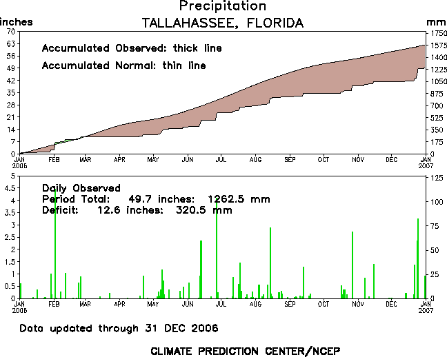
Figure 2. Rainfall in Tallahassee during the year 2006.
Following are some of the weather highlights that occurred in the NWS Tallahassee County Warning & Forecast Area in 2006.
January - Warm & Dry
Temperatures averaged 5 degrees warmer than normal during January. The mercury reached or exceeded 70 degrees on 17 days during the month. By contrast, there were only 5 mornings when temps dipped to the freezing point or lower, 6 fewer than normal. No temperature records were set during the month. January was also a very dry month, with less than half the normal rainfall. A 51-mph wind gust was reported on the 30th.
February - Wet then Cold then Warm
February was a fairly wet month with 7.35 inches of rainfall in Tallahassee. Most of this fell within just a few hours on the 2nd. The daily total of 4.47 inches broke the record for the date and was the most for any calendar day in 2006. This rainfall gave Tallahassee its only rainfall surplus of the entire year. Temperature-wise, February saw consistently colder than normal temperatures for the first half of the month. The low of 22 degrees on the 14th was the coldest of the 2005-06 winter season. The afternoon high of 46 degrees on the 12th was the coolest daytime high of 2006. There were 10 days with freezing temperatures recorded at Tallahassee. A quick transition to warmer than normal temperatures occurred mid month with daytime highs reaching the lower 80s on the 17th and 18th. Apalachicola tied their record high temperature of 78 degrees on the 23rd.
March - Very Dry/Record Monthly Maximum Temp
March, typically a stormy month, was very dry in 2006. Measurable rain fell in Tallahassee on only two days during the month, totaling just 0.29 inches. This makes March 2006 the fourth driest on record. Panama City and Apalachicola, FL, recorded similar amounts, 0.28 and 0.21 inches respectively. Only 0.13 inches of rain fell in Valdosta, GA. Temperatures were quite variable during the month, typical of Spring. The mercury soared all the way to 91 degrees in Tallahassee on March 21st. This not only broke the daily record, but also tied the record for the hottest temperature ever recorded in March, set previously on March 22, 1935. This marks the earliest date that the mercury exceeded 90 degrees in Tallahassee. Coincidentally, a record was also set for the latest 90+ degree day in the autumn on October 19, 2005. Thus this would be the shortest period between 90+ degree days in Tallahassee during the cool season, at just over four months. The coldest temperatures of the month occurred late in the month, with three consecutive days of freezing temperatures in the morning at Tallahassee from the 25th-27th. The low of 29 degrees on the 27th marked the last freeze of the season. Apalachicola set a record high of 79 degrees on March 3rd.
April - Dry & Very Warm
April is typically one of the driest months of the year. While more rainfall fell in April than March, the monthly total of 1.08 inches at Tallahassee was over 2.5 inches below normal. Most of this rain fell on the 22nd. The dry weather pattern was accompanied by unseasonably hot temperatures. The mercury reached or exceeded 90 degrees on six days during the month at Tallahassee. Record high temperatures were tied or broken on four days. The highest temperature for the month was 93 degrees on the 20th which established a new record for the day. The maximum temperature of 89 on the 3rd also broke the daily record. Readings of 92 on the 18th and 90 on the 15th tied records for those dates. The average temperature for the month of 70.6 degrees was over four degrees warmer than normal and this made April 2006 the 10th warmest on record at Tallahassee. Apalachicola tied a record high of 81 degrees on the 3rd. Albany, GA, tied their record high for the 19th at 90 degrees and broke the record for the 29th when the mercury reached the monthly maximum of 93 degrees. Temperatures in Albany averaged nearly 7 degrees above normal for the month. Panama City broke their daily record for the 6th with a high of 82 degrees and tied the record for the 13th reaching 85. Temperatures in Panama City averaged over 7.5 degrees above normal for the month.
May - Stormy with Near Normal Temps and Rainfall
May saw near normal temperatures and precipitation across the region. The month was primarily noted for its frequent episodes of strong to severe thunderstorms (see details below). An exception is Panama City which saw temperatures run four degrees above normal. Record high temps were broken on three consecutive days toward month's end with readings of 94, 95, and 94 degrees respectively on the 28th-30th. Apalachicola broke a record low on the 17th at 54 degrees and tied the record at 55 degrees the next day.
June - Tropical Storm Alberto - Late Month Heat Wave
The main weather highlight in June was Tropical Storm Alberto, which made landfall near Adams Beach, FL, in Taylor County, on Tuesday, June 13. A detailed report on the impacts to the local area from Tropical Storm Alberto can be found at here. Even though rainfall in June was above normal, it is notable that the only rain that occurred in an 18-day stretch from the 4th to the 22nd was that associated with Alberto. It is unusual to get such long stretches of dry weather in June. The wettest 24-hour period of the month in Tallahassee, 4.33 inches on the 27-28th, was actually not associated with the TS. Two daily rainfall records were set during the month, 2.67 inches on the 13th (Alberto), and 4.09 inches on the 27th. A record daily low temperature of 54 degrees was set on the 7th. Apalachicola also broke a record for that date dropping to 60 degrees and tied their daily record for the 19th with a low of 66 degrees. During a heat wave in the second half of June, Albany, GA, reached or exceed 100 degrees on three consecutive days from the 21st-23rd. The highs of 102 degrees on the 21st and 22nd established new daily records. These were also the highest temperatures recorded anywhere in the forecast area in 2006. Tallahassee peaked at 98 degrees during this period on the 22nd. Panama City reached 96 degrees on the 22nd, which set a new daily record. The hottest temperature of the year in Panama City, 99 degrees, occurred on the afternoon of June 30th.
July - Dry with near Normal Temps
July was much drier than normal across the region. At Tallahassee, rainfall for the month was less than half of normal. The first part of the month was particularly dry, with only 0.99 inches of rain falling through the 15th. Thunderstorms were reported on only two days during his period. The maximum annual temperature in Tallahassee for 2006 occurred on July 27th when the mercury reached 99 degrees. On July 9th, Apalachicola tied their daily record low temperature when they dipped down to 67 degrees. The low of 70 on the 11th also tied a daily record as did the low of 71 on the 27th. Panama City tied record high temperatures on the 1st and 2nd at 95 and 96 degrees, respectively, and broke the record for the 28th, when the mercury reached 98 degrees.
August - Persistent Warmth with Frequent Rain
August was the hottest month of the year in Tallahassee. Only two days had cooler-than-normal temperatures during the month. All 31 days were warmer than normal in Panama City. In fact, there was not a single cooler-than-normal day in Panama City for the entire summer. P.C. tied or broke four daily record high temperatures during the month on the 12th, 17th, 20th and 28th. While rains were frequent in August, the month still came in drier than normal. In Tallahassee, a new daily rainfall record was established on the 14th when 2.88 inches of rain fell at the airport. Most of this fell in just one hour with nearly half an inch (0.46 inches) falling in just four minutes!
September - Very Dry - Cool in Tallahassee
September was characterized by very dry conditions across the region with cooler than normal temperatures in Tallahassee, trends that persisted for most of the fall season. In contrast to August, there were only three days in September with warmer-than-normal temperatures in Tallahassee. The temperature reached 90 or better on only one third of the days. After the 5th, the temperature exceeded 90 on just one date. Temperatures for much of the last 2/3 of the month felt closer to what we would expect in October. However, no daily temperature records were tied or broken during the month. Rainfall for the month of September was about 40% of normal in Tallahassee, totaling just over two inches. In Panama City, 2.95 inches of rain fell, just under half of normal. Less than two inches of rain fell during the month at Dothan and Valdosta. Apalachicola got considerably more rainfall than the other stations. However, the 6.62 inches that fell was still about a half inch below normal.
October
October was 1.5 degrees cooler than normal in Tallahassee, continuing the trend for the season. However, an interesting coincidence occurred on the 19th when the mercury soared to 91 degrees. This tied the daily maximum temperature record, but also tied for the latest seasonal occurrence of temperatures above 90 degrees, which had been achieved just one year earlier in 2005. Panama City tied a daily record high temperature on the 5th at 90 degrees, and broke a record on the 18th when temps reached 88. A cold snap toward month's end broke two daily minimum temperature records at Apalachicola in a single night. The mercury dipped to 42 degrees just before midnight on the 23rd, breaking the record for that date, then bottomed out at 38 degrees on the 24th, setting a new record for that date as well. While rainfall was above normal for the month in Tallahassee, most of the rain fell on the 27th, with just over an inch falling for the entire remainder of the month. Rainfall in Panama City was above normal as well thanks to a 2.99 inch deluge on the 17th. Rainfall in Apalachicola was less than half of normal.
November - Persistently Cool with a Warm Start & Finish
November began and ended on a warm note, but cooler than normal temperatures persisted for most of the month. After a pleasant 82 degrees on the first, temperatures in Tallahassee were colder than normal on all but five of the next 25 days. Temperatures dipped into the 30s on ten mornings from the 13th to the 26th. However, the coldest temperature was 33 degrees, so there were no freezes observed during the month in the Capital City. There was a significant warm-up at month's end with temperatures running 10-15 degrees above normal over the last four days of the month and 80-degree high temps reached on the 27th and 29th. Panama City tied their daily record high on the 28th at 80 degrees. Overall, temperatures average 2 degrees colder than normal in November. November was also very dry with 2.38 inches of rain for the month. All but an inch of this fell on just one day on the 15th. Temperature and precipitation departures were similar across most of the rest of the region in November.
December - Cold Snap Early Followed by Long Warm Spell and Very Wet Holidays
December was a month of contrasts. The early part of the month was very dry with one of the coldest outbreaks of the year. This was followed by an extended warm spell, with copious rains around the holidays. The first official freeze of the season in Tallahassee occurred on the 4th when the airport dipped to 30 degrees. Freezes then occurred on four of the next five nights, with hard freezes on the 8th and 9th. The low of 21 degrees on the 9th was the coldest temperature of the year in Tallahassee and broke the record for the date. Records were also established that morning at Albany (20) and Apalachicola (30). A rapid transition to warmer than normal temperatures followed this hard freeze, and this warm spell lasted, with a few very brief interruptions, into mid January 2007. Freezing temperatures were recorded on just one occasion during this period at the Tallahassee airport. Temperatures exceeded 70 degrees on 16 of the last 21 afternoons during the month in Tallahassee, peaking at 79 degrees on the 18th and 19th. Despite the early cold snap, the month wound up averaging 3.6 degrees warmer than normal in Tallahassee. The month started out quite dry with just 0.32 inches falling in the first three weeks of the month in the Capital City. Then a pattern more typical of the ongoing El Nino finally set in with over eight inches of rain falling over the last ten days of the month. This deluge made December the wettest month of the year in Tallahassee. Most of the rain fell around the holidays. In fact, Tallahassee set a new daily rainfall record for Christmas Day at 3.72 inches. A whopping 24-hour total of 5.61 inches fell from Christmas Eve through Christmas Morning. Nearly an inch of rain fell on New Year's Eve. This abundance of rain significantly cut into our annual rainfall deficit, but 2006 still wound up being the 17th driest on record in Tallahassee.
Severe Weather
Typically, this part of the country sees a peak in severe weather activity during the spring months with a secondary maximum in November. Through summer, isolated severe storms are possible on almost any day, although large outbreaks are much less common. Occasionally severe weather occurs in the winter months, and some of these can be major outbreaks. 2006 generally followed these trends, although the spring peak occurred in February, rather than March, which was quite dry. Monthly summaries of severe weather occurrences in 2006 can be obtained by clicking the links below.
January | February | March | April | May | June | July | August | September | October | November | December
January
- During the evening of New Year's Day, torrential rains over a brief period triggered flash flooding throughout much of Houston County. Some county roads and several Dothan intersections were flooded.
- During the early morning of the 2nd, thunderstorm winds downed trees and power lines northeast of Bainbridge, GA (Decatur Co.) and over northeast portions of Grady County. Torrential rains of four to eight inches accompanied the storms, which produced flooding in Camilla, GA (Mitchell Co.) and throughout Tift County during the late morning and early afternoon. A funnel cloud was spotted south of Quitman, GA (Brooks Co.). Thunderstorm winds tore off a metal roof from a mobile home in northeast Leon County. A weak tornado (F0) briefly touched down and damaged a trailer and downed power lines in Sumatra, FL (Liberty Co.). Up to five inches of rain in less than two hours flooded a 30-ft section of Lower Bridge Road between Spring Creek, FL and U.S. Highway 98 (Wakulla Co.).
- Severe thunderstorms spawned weak tornadoes near Level Plains Crossroads, AL (Dale Co.), and at Tumbleton, AL (Henry Co.) on the afternoon of the 13th. The tornadoes damaged several chicken houses, a rental house, a church parsonage, several barns, and farm equipment. Thunderstorm winds downed trees in Enterprise, AL (Coffee Co.). Lightning struck and killed a man in Glendale, FL (Walton Co.). There were several reports of downed trees as severe thunderstorms moved across Clay and Early counties in southwest GA. Lightning knocked out a telephone system and seared a transformer at a restaurant in Pelham, GA (Mitchell Co.). An F1 tornado touched down near Norman Park, GA (Colquitt Co.) and destroyed two chicken houses, killing all 20,000 chickens inside. It sideswiped a restaurant, damaging a nearby shelter. It also destroyed several metal sheds and homes, damaged a dozen homes, and overturned irrigation pivots. One man was slightly injured when part of the ceiling of his mobile home collapsed.
- On the evening of the 30th, severe thunderstorms produced large hail in Dothan, AL (Houston Co.) and Bonifay, FL (Holmes Co.). Straight-line winds flattened pine trees and downed power lines in Cairo, GA (Grady Co.).
February
- Three to five inches of rain in less than two hours flooded several intersections and low-lying areas in Valdosta, GA (Lowndes Co.) on the afternoon of the 2nd. The torrential downpour collapsed the roof of a video store. Up to four inches of rain in less than two hours flooded several county roads and low-lying areas in Leon County. Lightning damaged an unoccupied mobile home in Tallahassee, FL (Leon Co.). Large hail was reported in Jefferson, Leon, and Wakulla counties. A waterspout moved across Apalachicola Bay and destroyed seven utility poles which cut power to more than 2,000 customers on St. George Island.
- A squall line of severe thunderstorms produced numerous reports of large hail across Wakulla, Leon, Franklin, Jefferson, and Madison counties in Florida, and Lowndes County, GA during the late afternoon and early evening of the 3rd. Some of the hailstones were as large as golfballs.
March
- Thunderstorm winds tossed a mobile home and toppled trees north of Ellenton, GA (Colquitt Co.) on the morning of the 14th.
- During the morning of the 21st, winds from a severe thunderstorm damaged a few homes, a barn, and a water pump in Holmes Co., FL. A microburst blew down numerous trees and power lines northeast of Cairo, GA. One home lost part of its roof.
April
- Severe thunderstorms produced numerous reports of large hail across portions of southeast Alabama, southwest Georgia, and northwest Florida during the afternoon of the 8th. Also, thunderstorm winds blew a roof off a carport north of De Funiak Springs, FL (Walton Co.), and downed trees in portions of Madison County, FL as well as Tift, Berrien, Irwin, Thomas, Brooks, Lowndes, and Lanier counties in Georgia.
- Large hail was reported in Thomasville and just east of Cairo, GA, and winds blew down a few trees near Elmodel, GA (Baker Co.) during the late afternoon of the 18th.
- On the evening of the 19th, large hail fell in Albany, Dawson, Norman Park, and just south of Smithville, GA. Also, some trees were blown down in Albany.
- Severe thunderstorms produced numerous reports of quarter to golfball size hail across portions of Wakulla, Leon, Franklin counties in the Florida Big Bend on the 22nd. Two waterspouts were observed by the public near St. George Island. Penny size hail was reported in Carnegie, GA (Randolph Co.) and trees were knocked down west of Bluffton, GA (Clay Co.).
- During the late morning of the 26th, thunderstorm winds blew the roof off a home northwest of Bonifay, FL (Holmes Co.) and downed trees throughout Jackson County, FL. That afternoon, some trees and power lines were toppled across Worth and Tift counties in South Georgia. Also, shingles were peeled off the roof of a house just north of Bainbridge, GA.
May
- A funnel cloud was reported north of Wakulla, FL, and thunderstorm winds knocked down trees north of Cairo, GA on the 5th.
- On the 7th, severe thunderstorms produced several reports of large hail in Jackson, Washington, and Bay counties of the Florida Panhandle, while winds downed trees in Liberty, Jefferson and Madison counties of the Florida Big Bend. Tents were blown over in Madison, FL.
- Nickel size hail fell in and just east of Dothan, AL during the late evening of the 8th. Earlier that day, numerous reports of large hail were received across portions of the Florida Big Bend. Winds toppled utility poles which disrupted power to the Tallahassee Memorial Hospital. Quarter size hail fell in Bainbridge, GA.
- Just after midnight on the 9th, straight-line winds estimated between 70 and 80 mph downed numerous trees and utility poles throughout Bay County, FL. There was considerable damage to numerous homes and businesses in Panama City and Parker, FL. Metal awnings were damaged at a local marina. Several small planes at the Panama City-Bay County Airport were torn from their ties downs and tossed into hangers and each other. One plane was flipped over and a hanger door was blown out. Large hail was reported east of Apalachicola and in Port St Joe, FL. A waterspout was sighted on the U.S. Highway 98 bridge southeast of Apalachicola. During the late evening, quarter size hail fell in Clarksville, FL (Calhoun Co.), and numerous trees were blown down in Chipley (Washington Co.).
- There were several reports of large hail during the evening hours of the 10th across portions of southeast Alabama and the Florida Big Bend. Thunderstorm winds downed trees and power lines in Enterprise, Geneva, and Shorterville (Henry Co.). There were numerous reports of wind damage throughout southwest and south central Georgia. In Warwick, GA (Worth Co.), winds peeled the top off a water tower and bent the police department's communication antenna. Several mobile homes were damaged in Lee County.
- Thunderstorm winds knocked down some trees just northwest of Tallahassee, FL just after midnight on the 11th.
- During the late afternoon and early evening of the 14th, severe thunderstorms deposited large hail across Worth, Dougherty, and Irwin counties in Georgia. A USDA official reported crop damage from quarter to half dollar size hail in central Worth County. Winds knocked down trees at Days Crossroads, GA (Clay Co.). A man was struck and killed by lightning outside his home in Mystic, GA (Irwin Co.).
- Large hail fell just east of Marianna, FL (Jackson Co.) during the early morning of the 15th.
- Afternoon thunderstorms on the 24th produced golfball size hail southeast of Tallahassee, in Crawfordville, and west of Dowling Park, FL (Lafayette Co.).
- During the afternoon of the 25th, hail fell in Marianna, as well as near Baconton, GA (Mitchell Co.) and Irwinville, GA (Irwin Co.). Also, thunderstorm winds knocked down a few trees near Baconton.
- Thunderstorm winds blew down a few trees south of Blountstown, FL (Calhoun Co.) late in the afternoon of the 27th.
- Early afternoon on the 28th, a young girl drowned in a rip current while swimming at St. Andrews State park near Panama City Beach. A teen girl was rescued. Later, severe thunderstorms produced hail near Cairo, FL (Bay Co.), and minor wind damage at Day and Perry, FL (Taylor Co.). In portions of South Georgia, hail and wind damage was reported. Lightning was blamed for two house fires in Tifton, GA.
June
- Tropical Storm Alberto affected the Florida Panhandle and Big Bend, as well as portions of South Georgia from the 12th through the 14th. See the above section for details on Alberto. See our event web page for additional details.
- Severe thunderstorms developed during the late afternoon of the 22nd. These storms produced wind damage in Pansey and near Abbeville, AL (Henry Co.), near Damascus, Colquitt, and Georgetown, GA (Quitman Co.), and near Greenville, Lee, Hosford, Esto, and Clarksville, FL.
- Thunderstorm winds downed trees and power lines, and damaged a church roof and pump house in Samson, AL (Geneva Co.) on the 24th.
- During the late afternoon and early evening of the 25th, thunderstorm winds destroyed a shed and overturned trailers in Geneva, AL. In Dothan and Midland City, AL, numerous trees and power lines were down. Several newly constructed walls of a high school collapsed in New Brockton, AL (Coffee Co.). Hail fell along U.S. Highway 231 near Bayou George, FL. Severe thunderstorms were also to blame for wind damage near Nickleville, Calvary, and Albany, GA. Nickel to quarter size hail fell near Albany, GA. Torrential rains caused flash flooding near Albany and northeast of Camilla, GA (Mitchell Co.). There were numerous reports of waterspouts just offshore of the Hickory Mound Impoundment (Taylor Co.), and near the entrance to the St. Marks River.
- Winds damaged a large video screen at the Wild Adventures Theme Park near in Clyattville, GA (Lowndes Co.) on the evening of the 26th.
- An afternoon thunderstorm dropped quarter size hail in Concord, FL (Gadsden Co.) on the 27th.
July
- On the evening of the 6th, thunderstorms produced penny size hail in Monticello, FL, and wind damage to trees and power lines north of Madison, FL. Four waterspouts were sighted offshore of Miramar Beach, FL on the morning of the 13th.
- On the 16th, thunderstorm winds downed trees and destroyed a barn west of Samson, AL (Geneva Co.), downed trees in Lenox, GA (Cook Co.), and downed power lines in Valdosta, GA.
- During the afternoon of the 19th, severe thunderstorms toppled trees and utility poles in Wewahitchka, FL (Gulf Co.), dropped quarter size hail in Five Points, FL (Washington Co.), and produced a peak wind gust of 71 mph at the Panama City-Bay County Airport. Also, wind damage to trees, power lines and a sign was reported in Moultrie, GA.
- Quarter size hail fell in Bayou George, FL (Bay Co.) on the 20th.
- Thunderstorm winds downed several trees in Lucile, GA (Miller Co.) and south of Quitman, GA (Brooks Co.) on the afternoon of the 22nd.
- Thunderstorm winds downed trees and blew a car off a highway just west of Damascus, GA and downed trees south of Blakely, GA (both in Early Co.) during the afternoon of the 25th.
- On the evening of the 27th, winds downed several trees northeast of Cross City, FL and just east of Mayo, FL (Lafayette Co.). Also, hail up to golfball size and downed trees and power lines were reported in Valdosta.
- From late afternoon through early evening on the 28th, roofs were blown off sheds and trees were blown down northwest of Perry, FL and in Econfina, FL (Taylor Co.), and at Cherry Lake, FL (Madison Co.). Large hail was reported six miles west of Chiefland, FL (Dixie Co.), and in the vicinity of Marianna, FL. In south central Georgia, trees and power lines were down in Sylvester, Lake Park, and just east of Valdosta. Also, nickel size hail fell south of Lakeland, and quarter to golfball size hail was observed just north of Pritchetts (Worth Co.). Thunderstorms produced minor wind damage to trees in Vernon, FL (Washington Co.), and dropped penny size hail in eastern Gulf County, FL on the 29th.
August
- On the afternoon of the 4th, severe thunderstorms dropped nickel size hail in and southeast of Lakeland, GA (Lanier Co.). There were several reports of wind damage to trees and power lines in Colquitt County, GA. Two homes were damaged by fallen trees and two irrigation pivots were damaged from just east of Lakeland to Stockton, GA. Also, trees and power lines were down in northeast Valdosta, and in Blakely, GA.
- Severe thunderstorms affected much of the region throughout the afternoon and early evening of the 8th. In southeast Alabama, significant wind damage occurred across Dale County. Several buildings, a few homes and a gazebo were damaged in Midland City. Also, power outages lasted up to nine hours. In Pinckard, three major high voltage power lines were blown down. Lightning caused extensive damage to a Panama City Beach, FL home. A few trees were down north of Bonifay, FL. Most of the wind damage reports occurred across southwest and south central Georgia, and were classified as downed trees and power lines. Some vehicles were damaged by fallen trees in Valdosta. Penny size hail fell in Enterprise (Miller Co.) and Thomasville. Lightning destroyed a home in Edison (Calhoun Co.) and injured a person in Valdosta. Finally, a funnel cloud was observed north of Dawson (Terrell Co.). See our event web page for additional details.
- On the 12th, thunderstorm winds knocked down trees and power lines just east of Crawfordville, FL, and lightning destroyed a home in Moultrie, GA.
- During the evening of the 15th, penny size hail fell in Bruce, FL (Walton Co.). In southeast Alabama, thunderstorm winds toppled trees in Level Plains Crossroads (Dale Co.) and just west of Dothan. A funnel cloud was sighted in Enterprise. Lightning destroyed a home just south of Newton.
- Thunderstorm winds damaged a double-wide trailer and two sheds in Ewell and downed trees and power lines in Ozark, AL (both in Dale Co.) on the 30th. Also, a few trees were down just northeast of Elba, AL (Coffee Co.).
September
- No severe weather was reported.
October
- A weak (F0) tornado touched down in Bayou George, FL just before sunrise on the 22nd. The tornado uprooted numerous trees, damaged several homes, and destroyed a shed. A few hours after the tornado, a waterspout was sighted over West Bay.
- Warm moist, unstable air in advance of approaching cold front produced several tornadoes across the eastern Florida Panhandle and western Big Bend during the afternoon and evening of the 27th. An F0 tornado flipped a Frito-Lay truck on its side in the Winn-Dixie parking lot near the Phillips Inlet area of western Bay County. The tornado then became a waterspout as it moved over Lake Powell before dissipating. The most significant severe weather occurred when a waterspout came ashore as an F1 tornado just southwest of Apalachicola. The tornado cut a path approximately 1.5 miles long and more than 100 yards wide through the downtown area, damaging a fast food restaurant, school, hospital, electric power substation, and dozens of homes. Hundreds of trees were either uprooted or had their tops sheared off. Later that evening, a line of severe thunderstorms downed trees and power lines in Monticello, as well as portions of Taylor and Lafayette counties. See our event web page for additional details.
November
- A squall line affected the region on the 15th. Isolated supercell thunderstorms developed ahead of the line across southeast Alabama during the afternoon. A cyclical supercell spawned an F1 tornado just northeast of Elba. The parent circulation weakened as it moved northeast, but strengthened once again just north of Roeton, with F0 damage reported. This tornado would eventually produce F2 damage as it entered Pike County. Another supercell moved into Henry County and generated an F1 tornado north of Headland, which damaged a yeast plant and several homes, and also knocked down trees and power lines. There was widespread wind damage just north of Haleburg and in Headland. Up to five inches of rain flooded roads and a recreation area just south of Hartford. Across the Florida Panhandle, thunderstorm winds downed trees west of Mossy Head (Walton Co.) and in Pittman, Ponce De Leon and Bonifay (Holmes Co.). A fence and nearby house were damaged, along with downed trees in De Funiak Springs. In Campbellton (Jackson Co.), trees and a carport were blown down. The line weakened as it moved into southwest Georgia and the Florida Big Bend during the evening, and produced several reports of very heavy rain and hail. Hail up to the size of baseballs was reported north of Adams Beach, FL (Taylor Co.).
December
- During the predawn hours of Christmas Day, a line of severe thunderstorms downed trees and blew out windows of several homes in Ocilla, GA (Irwin Co.), and downed trees and power lines in eastern Ben Hill County. A supercell thunderstorm spawned an F1 tornado east of Fitzgerald, GA (Ben Hill Co.) just before sunrise. The tornado traveled 12 miles to the northeast, with an intermittent damage swath about 100 yards wide.
Previous Years
Reviews of local weather in 2005, 2004, 2003, 2002, 2001 and 2000 are also available.
National Weather in 2006
An article summarizing last year's weather across the country has been published by NOAA. A more detailed summary has been posted by NCDC. Also included in this site is a collection of significant weather events that occurred nationally last year.

