| A Review of Local Weather in 2007 |
The 2007 Hurricane Season was a quiet one for the U.S. This is despite the fact that the season across the Atlantic Basin as a whole was a long one. Subtropical Storm Andrea developed on May 9, three weeks before the official start of hurricane season, while Tropical Storm Olga did not dissipate until December 12, nearly two weeks past the official end of the season. Only one hurricane made landfall in the U.S. this season. Hurricane Humberto came ashore on the upper Texas coast on 13 September. There were two U.S. tropical storm landfalls. TS Erin impacted Texas and Oklahoma in mid August, while TS Gabrielle reached the Outer Banks of North Carolina during the 2nd week of September. Two tropical depressions also reached U.S. shores, Barry in early June and TD 10 in late September. Both of these had minimal impacts on the local forecast area and are discussed in detail below.
As can be seen in Figure 1 (below), temperatures started out warmer than normal at the beginning of the year, with above normal temperatures for the first half of January. A transition to cooler than normal temperatures occurred for the last half of the month and most of February. Warmer than normal temperatures resumed in late February and continued through most of March and into early April, while most of April was cooler than normal. On average, the months of May and June saw near normal conditions. Beginning in late June, a lengthy period of above normal temperatures commenced, which lasted the remainder of the summer. In fact, August was the hottest on record in Tallahassee and the summer season as a whole (June through August) was the 2nd hottest on record. Warm temperatures continued through September and October, with October being well above normal. A sharp turn to below normal temperatures began in early November and lasted a few weeks. Warmer than normal conditions returned late in the month and continued for the remainder of the year, with December being considerably warmer than normal. Temperatures in Tallahassee for the year ranged from a maximum of 102 degrees on July 20th to a minimum of 18 degrees on February 17th. This was the first summer since 2002 that the mercury reached the century mark in Tallahassee. There were three such days this year, with seven other days falling just shy at 99 degrees. Dothan, AL, reached or surpassed 100 degrees 6 times this year, including 5 times in a 6-day stretch in early August. Albany, GA, hit the century mark seven times, including a stretch of 6 days in a row in that same August heat wave. The 106-degree reading on August 7th was the hottest temperatures recorded in the forecast area in 2007 and the hottest temperature in recent memory in this part of the country. The average temperature for all of 2007 was 68.9 degrees, which was 0.9 degrees above normal. Overall, temperatures were above normal for much of the year and 2007 will go into the books as tied for the 13th warmest on record in Tallahassee.

Figure 1. Temperatures in Tallahassee during the year 2007.
Figure 2 (below) shows that Tallahassee ran a precipitation deficit for virtually the entire year. This was the second year in a row with considerably below normal rainfall. While there were several notable rainfalls during the year, the spring and autumn months were unusually dry. In fact, the Spring of 2007 was the driest on record with only 2.24 inches of rain falling from March 1 to May 31. This broke the old seasonal record, set way back in 1925, by well over an inch. Only August and October recorded above normal monthly rainfall. The wettest calendar day of the year was February 1, when 3.95 inches of rain fell. The wettest month was August with 8.05 inches of rain. The annual rainfall total was 44.47 inches in The Capital City, which is 18.74 inches below normal. This makes 2007 the ninth driest year on record dating back to 1895, and the driest year since 1955, over 40 years ago.
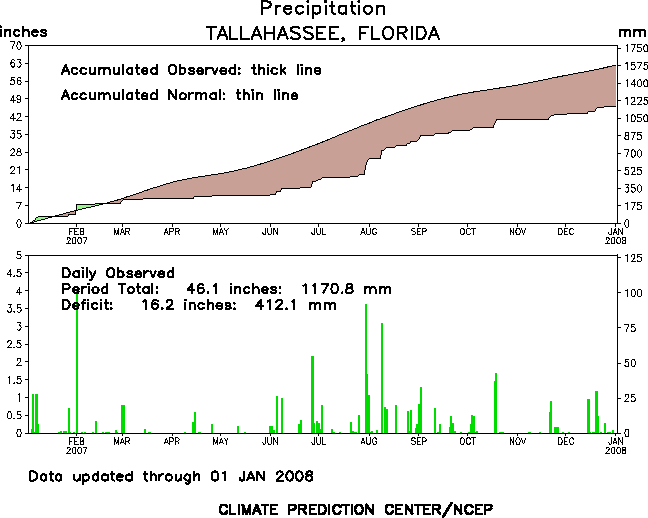
Figure 2. Rainfall in Tallahassee during the year 2007.
Following are some of the weather highlights that occurred in the NWS Tallahassee County Warning & Forecast Area in 2007.
January - Warm Start - Cold Finish
Temperatures averaged 2.3 degrees warmer than normal during January. An unusually long stretch of mild weather that began the 2nd week of December continued through the first half of the month. The mercury reached or exceeded 70 degrees on 9 of the first 15 days of the month. The highest temperature of the month in Tallahassee was 79 degrees on the 6th, which established a new record high for the date. Cold weather finally arrive in the third week of the month, but there were only 4 mornings when temps dipped to the freezing point or lower, 7 fewer than normal. January was a drier than normal month, with just shy of 2/3 the normal rainfall. There were no thunderstorms reported during the entire month.
February - Cold & Dry with a Wet Start and Warm Finish
February was a month of contrasts in Tallahassee. There was 4.43 inches of rainfall during the month, but most of this fell on the first day. The daily total of 3.95 inches on February 1 broke the record for the date and was the most for any calendar day in 2007. This rainfall gave Tallahassee its last rainfall surplus for the entire year. The remaining 27 days of the month were very dry with just 0.40 inches of rain falling. Temperature-wise, February saw consistently colder than normal temperatures for the first three weeks of the month, which averaged 3.1 degrees colder than normal overall. The low of 18 degrees on the 17th was the coldest of the 2006-07 winter season and set a new record for the date. The afternoon high of 46 degrees on the 15th was the coolest daytime high of 2007. There were 7 days with freezing temperatures recorded at Tallahassee. A quick transition to warmer than normal temperatures occurred for the last week of the month, with daytime highs reaching the lower 80s on the 27th and 28th. Apalachicola tied record lows on the mornings of the 16th and 19th and set a new record high temperature of 80 degrees on the 22nd.
March - Tornado Outbreak, then Warm & Dry
March, typically a stormy month, was very dry in 2007. However, the month came in like a lion and went out like a lamb. From Thursday, March 1, through the early morning hours of Friday, March 2, 2007, the NWS Weather Forecast Office in Tallahassee issued 57 warnings included 35 tornado, 19 severe thunderstorm, and 4 special marine warnings. During this time, warnings were issued for two deadly tornadoes, which caused the loss of 15 lives, nine in Enterprise, AL, and six just north of Newton, GA. Figure 3 shows the extent of the severe weather outbreak. Additional details can be found in the event web page. Like in February, most of the month's rainfall fell at the very beginning of the month. Only 0.12 inches of rain fell from the 3rd through the 31st. The monthly total of 0.90 inches made this month the 5th driest March on record. There were three days during the month that dipped to freezing or below at the Tallahassee airport. The low of 32 degrees on the 18th marked the last freeze of the season. The last freeze of the season at Apalachicola occurred on the 5th. There were no daily temperature or precipitation records set during the month.

Figure 3. Extent of the severe weather outbreak of March 1-2, 2007. Tornado paths are indicated in charcoal gray. Areas of straight-line wind damage are indicated by white rectangles. Click on the image for a larger view.
April - Mid-Month Severe Weather - Cooler & Drier than Normal
April is typically a dry month, but rainfall in Tallahassee was only 1/3 of normal. This extended the dry spell that began on February 2 to nearly three months. The month started and ended on a hot note, with the mercury reaching 90 degrees on the 4th and 30th. In between, temperatures were generally cooler than normal. An unseasonably cool stretch of weather occurred from the 7th-9th. Daytime highs at Tallahassee were just 58 degrees all three days, tying or breaking daily records for coolest daytime maximum temperature each day. The coldest temperature of the month was 33 degrees on the morning of the 8th. Overall, temperatures averaged 2 degrees cooler than normal for the month. The 2nd significant severe weather outbreak of the season occurred mid-month, from Saturday evening, April 14, through the early morning hours of Sunday, April 15. Warnings included 8 tornado, 21 severe thunderstorm, and 5 special marine warnings. Three tornadoes were confirmed by NWS survey crews, one each in Dale County, AL, and Lee and Worth Counties in GA. Figure 4 shows the extent of the severe weather outbreak. Additional details can be found in the event web page.

Figure 4. Damage paths of the three tornadoes of April 14-15, 2007, indicated by the charcoal gray ovals. Click on the image for a larger view.
May - Very Dry & Smokey
May saw near normal temperatures, but was exceptionally dry. Measurable rainfall occurred on only two days during the month, with the monthly total just 0.20 inches. This is just 4 percent of normal and makes May 2007 the 3rd driest on record. Overall, the spring season was the driest on record in Tallahassee, and the period January through May the 4th driest. It is interesting to note that 3 of the top 8 driest springs on record have occurred in the last 4 years. The excessive dry weather during the spring resulted in several large wildfires over northeast Florida and Southeast Georgia. Persistent east winds during May frequently brought smoke westward from these fires into the local area. Smoke and/or haze was reported at the Tallahassee airport on 24 days during the month. The smoke was even thicker over eastern portions of the Florida Big Bend and South Central GA, where several dense smoke advisories were issued during the month. Dry air usually results in greater diurnal temperature swings, with cooler than normal temperatures at night and hotter temperatures during the day. Apalachicola, FL, set a record low of 49 degrees on May 8th, the second coolest temperature for so late in the season. Just 5 days later, the site recorded a daily record high of 92 degrees on the 13th.
June - Hot with Some Rain - TD Barry
June was rather uneventful, but at least brought some much needed rainfall, especially across eastern portions of the Florida Big Bend. Barry, the 2nd named storm of the young Atlantic hurricane season came ashore near Tampa Bay as a depression on the morning of June 2nd. Being on the "weak" side of a weakening depression, it is not surprising that our forecast area got very little wind and virtually no storm surge. However, the depression did bring some beneficial heavy rains to parts of the area, with 2- to 4-inch rainfall amounts common across eastern portions or the Big Bend and the Suwannee Valley. The highest rainfall total in the forecast area was measured at Dowling Park, FL, where 6.40 inches of rain fell. Rainfall totals were far less to the northwest, with Tallahassee getting about half an inch and Dothan and Panama City getting absolutely no rain from the system. In the wake of the depression, the first true heat wave of the season set in, peaking from June 8-11th. Tallahassee reached 100 degrees on the 10th, marking the first time the Capital City officially reached the century mark since July 19, 2002. The next day, the high temp of 101 degrees set a new record for the date. Dothan reached 100 degrees on that date. Apalachicola set a record of 98 degrees on the 9th. Despite missing out on most of Barry's rains, Tallahassee recorded 5.85 inches of rain for the month, or 85% of normal. The 2.26 inches of rain that fell on the 27-28th was the heaviest rainfall since February 1. A 52-mph thunderstorm wind gust was recorded at the airport on the 12th. Dothan got much less rainfall for the month, just 1.88 inches.
July - Hot & Dry with a Late-Month Deluge
July continued the trend of hot and dry weather. Tallahassee soared to 102 degrees on the 20th, breaking the old record high for the date of 100 set in 2000. This was the hottest temperature observed at the airport since that impressive heat wave of mid-July 2000. Apalachicola tied their record high of 96 degrees on the 1st. Temperatures for the month averaged 1.1 degrees above normal, but the average daily maximum temperature was nearly 2.5 degrees above normal, with the majority of days in the month reaching the mid to upper 90s. The bigger story was the continuation of the very dry weather. Through the first 29 days on the month, only 2.16 inches of rain had fallen at the Tallahassee airport, setting a pace for the 2nd driest July on record. Then the heavens opened up and a whopping 5.27 inches of rain on the last two days of the month. This actually brought the monthly total pretty close to normal. Other areas were not so lucky. Panama City recorded just over 2 inches of rain for the month.
August - Hottest on Record - Wet Too
August was the hottest month of the year in Tallahassee. In fact August 2007 was the hottest August observed since records began and the third hottest month of all time behind July 1932 and June 1998. Only four days had cooler-than-normal temperatures during the month. This record was established despite the fact that the mercury never officially hit 100 degrees at the airport. The hottest temperature for the month was 99 degrees on the 9th, 10th, 14th, 15th and 22nd. Daily record high temperatures were established on the 9th, 10th, 11th and 14th. Records for highest daily minimum temperature were tied or broken on the 7th, 11th, 15th, 20th and 23rd. Records for highest daily mean temperature were set on the 6th, 7th, 9th, 10th, 11th, 14th, 22nd and 24th. Elsewhere, Panama City reached their summer maximum of 100 degrees on August 22nd. Daily minimum temperatures were 80 degrees or above on four days during the month, with the mercury never falling below 84 degrees on the 11th. Apalachicola set a daily record of 97 degrees on the 23rd. The heat wave that gripped the area during the 2nd week of the month was even more intense north of Florida. Dothan, AL, recorded daily maximum temperatures of 100 degrees or higher on 6 days during the month. In Albany, GA, there were 6 consecutive days of 100-degree heat from the 6-11th, with 5 other days in the month reaching 99 degrees. The hottest temperature of the year in the forecast area occurred in Albany on the 7th when the mercury soared to 106 degrees. The average high temperature for the month of August in Albany was 96.2 degrees, and the average monthly temperature was 4.7 degrees above normal. August was the first month of the year to post a rainfall surplus. The 8.05 inches of rain that fell in Tallahassee was just over an inch above normal. A new daily rainfall record was established on the 9th when 3.09 inches of rain fell at the airport. A 52-mph thunderstorm wind gust was recorded at the airport on the 9th.
September - TD 10 - Warmer than Normal
Tropical Depression 10 came ashore near Fort Walton Beach on the evening of September 22nd. While a minimal tropical storm force wind gust was measured at an offshore buoy, the peak gust over land was just 35 mph at Apalachicola, FL. This location also recorded the maximum rainfall from the depression, 2.37 inches. Even more rain fell earlier in the month on the 6th when 3.26 inches of rain was recorded. These two events contributed to a monthly total of 9.14 inches of rain at Apalachicola, over 2 inches above normal. Warmer than normal conditions persisted during September. Only two days were cooler than normal during the month in Tallahassee. There were no temperature records tied or broken during this month.
October - Warm & Wet
October was considerably warmer than normal in Tallahassee, continuing the trend of the previous 5 months. The average temperature for the month was 4.2 degrees above normal, making October 2007 the 7th warmest of all time in Tallahassee. The highest temperature for the month was 91 degrees on the 4th, 5th and 10th. The latter tied the record for the date. October was only the 2nd month of the year to record above normal rainfall in Tallahassee. The 4.49 inches that fell was 1.24 inches above normal. The greatest 24-hour total was 3.12 inches on the 18-19th. Apalachicola set a daily rainfall record on the 19th with 3.53 inches. The 24-hour total was 3.94 inches on the 18-19th.
November - Cooler & Very Dry
November was only the 3rd month of the year to average cooler than normal. Temperatures for the month were 2.2 degrees below normal. The first freezing temperature of the season occurred on the 7th in Tallahassee. Below freezing temperatures also occurred on the 8th and 9th and again on the 16th and 17th. The coldest temperature of the fall season occurred on the 17th when the mercury bottomed out at 26 degrees. While Tallahassee did not establish any new temperature records for the month, Apalachicola's low of 34 degrees on the 8th tied the record for the date. The low of 34 on the 17th broke the record for that date. November was another very dry month in Tallahassee. Only 0.01 inches of rain was recorded over the first three weeks of the month. The monthly total of 1.22 inches was less than a third of normal. Less than an inch of rain fell in Albany, GA, and rainfall was also well below normal in Valdosta. A couple of heavier rainfall episodes occurred further west. Panama City received 1.27 inches of rain on Thanksgiving Day. Dothan, AL, got 4.01 inches on the 26th, with less than half an inch falling on the other 29 days of the month.
December - Dry and Very Warm with Mid-Month Severe Weather
December saw a return to warmer than normal conditions. In fact, December was 0.1 degrees warmer than November in Tallahassee, a rare occurrence indeed. The average temperature for the month was 4.6 degrees above normal. The coldest temperature of the month was just 30 degrees. There were only 4 days that saw freezing temperatures at the airport, 6 fewer than normal. There were three brief cold snaps during the month. The coolest afternoon occurred the day after Christmas, when the high was only 47 degrees. Unseasonable warmth was far more common. The mercury reached or exceeded 80 degrees for 5 consecutive days, with temperatures reaching the upper 70s to lower 80s from the 8th to the 14th. The 81-degree reading on the 9th tied the record for the date. A record high was also tied at Panama City that day at 80 degrees. Albany, GA, reached 82 degrees on the 9th, 11th and 12th. Another period of very warm weather preceded the end of the year. Tallahassee had highs in the upper 70s from the 29th through the 30th. Both Albany and Valdosta reached 80 on the 29th. While the southern half of the forecast area had drier than normal conditions for the month, several significant rainfall episodes occurred further north. Dothan recorded 7.79 inches of rain for the month. Heavy rain affected the northwest portion of the forecast area mid month, around the 20th and again from the 28th-30th. The mid-month rains were associated with a severe weather outbreak. Beginning Saturday afternoon, December 15, and continuing into the early morning hours of Sunday, December 16, 2007, the NWS Weather Forecast Office in Tallahassee issued 18 warnings. These included 5 tornado, 7 severe thunderstorm, and 6 special marine warnings. Two tornadoes were confirmed by NWS survey crews, which tracked across Early, Worth, and Turner Counties in GA. Unfortunately, there was 1 fatality in Ashburn, Georgia. Figure 5 shows the damage path of the tornadoes that struck Worth and Turner Counties in GA on the evening of the 15th. Additional details can be found in the event web page.

Figure 5. Damage path of the tornado of December 15, 2007, indicated by the charcoal gray oval. Click on the image for a larger view.
Severe Weather
Typically, this part of the country sees a peak in severe weather activity during the spring months with a secondary maximum in November. Through summer, isolated severe storms are possible on almost any day, although large outbreaks are much less common. Occasionally severe weather occurs in the winter months, and some of these can be major outbreaks. 2007 generally followed these trends. Monthly summaries of severe weather occurrences in 2007 are outlined below.
Previous Years
Reviews of local weather in 2006, 2005, 2004, 2003, 2002, 2001 and 2000 are also available.
National Weather in 2007
NCDC provides a collection of significant weather events that occurred nationally last year.

