The air movement around a supercell is very complicated with updrafts and downdrafts both occurring with their complex interactions. In addition to the previously mentioned rotating updraft and appearence, there are three addition components underneath the supercell, each of which contribute to the overall storm structure.

This is the location of the storm's main rain-cooled region. Since mid-level atmospheric wind tilt the updraft, this downdraft is displaced downwind.
Therefore, FFD is located north, northeast or east of the updraft depending upon the storm's motion. At this location the falling air does not chock off the updraft thereby allowing the storm to maintain its longevity.
The amount of precipitation that falls is dependent upon the overall moisture content of the atmosphere. These further divides supercells into two categories; HP Supercells and LP Supercells.

In HP (High Precipitation) supercells precipitation often surrounds the updraft, and may hide it completely. They can have a wall cloud, but it may also be obscured by the heavy precipitation. Also, as these storms produce blinding precipitation, damaging winds and large hail, your visibility of any tornadoes may be obscured.
On the other hand, in LP (Low Precipitation) supercells, the overall appearance of the storms is like a barber pole or corkscrew appearance. Often the most photogenic, precipitation from LP supercells is sparse and/or well removed downwind from the updraft below cloud base.
Large hail is often difficult to discern visually. Although precipitation may not be apparent below the storm, sometimes very large hail is falling that cannot be seen at a distance.
This is the "action" area of a supercell. It is where the strongest updraft is located and the area where tornados normally develop. Wall clouds form when warm, moist inflow meets the cool, moist outflow from the forward flanking downdraft.
The convergence of these two moist airflows are ingested in the updraft resulting in a low cloud formation. The moist inflow along the FFD may condense into cloud that merges with the wall cloud.
This formation is called a tail cloud though occasionally called by its slang term, beaver's tail. Even though the updraft of a supercell rotates not all wall clouds rotate. Also, the heavy precipitation in an HP supercell may obscure a wall cloud.
The wall cloud will be on the northern side of the rear flank downdraft.
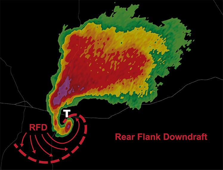
Studies indicate the RFD is a key component in the formation of tornadoes. The RFD develops as mid latitude wind from outside of the storm wrapping around the updraft and forced to the ground as a response to pressure patterns within the thunderstorm.
This causes the air in the RFD to warm and dry and immediately be wrapped back into the updraft itself to intensify its rotation forming a tornado.

Unlike the rain-cooled forward flank downdraft, the RFD is, more times than not, dry and warm. As the air descends it warms by compression and clears out clouds forming a "clear slot".
Identifying the clear slot will greatly assist you by focusing your attention to the most likely area from which a tornado may form. The clear slot is most readily spotted by looking for a horseshoe-shaped pattern in the cloud base.
This horseshoe shape results from the RFD pushing out and under the updraft. The northside of the horseshoe is the most likely place for the formation of a tornado.
Caution, anticyclonic tornadoes can form on the south side of the horseshoe. These tornados are usually short lived and weaker but can be dangerous as they are often unexpected.
In some high prescription supercells, the RFD can be "wet" as they are filled with falling precipitation. Wet RFD are not favorable with tornadoes (not that they can’t occur) but their largest concern is the lack of visibility.
If you observe a wet RFD, it will likely contain very large hail, high winds and obscure any tornado that may exits. Do not attempt to drive through a wet RFD "for a better view".
As with any supercell, you need to be very much aware of your location relative to the storm. The RFD may contain sustained winds over 100 mph and hail larger than baseballs. It can produce more significant damage than the tornado itself.