Cold temperatures will continue across much of the eastern U.S. into today. Heavy lake effect snow continues into today east of Lakes Erie and Ontario. Two Pacific cold fronts will cross the Pacific Northwest early this week followed by another atmospheric river. Heavy rain and gusty winds are expected through midweek, with the potential for renewed urban and river flooding. Read More >
A graphical review of the significant weather events for the region in 2013 is available below.

 |
 |
Annual summary for the state of Oklahoma from SCIPP.

Annual summary for north-central Texas from SCIPP.

Monthly Temperature Statistics from Selected Sites in Oklahoma and western north Texas

 |
 |
January was generally the "calm before the storm" in the winter of 2012-13, featuring above average temperatures and below average precipitation. A much colder and more active pattern arrived in early February, bringing a series of winter storms to the southern Plains over the remainder of the month. Northern and western Oklahoma were hardest-hit.
The first significant storm arrived on February 11-12. Much of the area north and west of I-44 saw over 2" of snowfall, with the bullseye in far southwest Oklahoma, where Sayre recorded 9". After a brief period of mild and dry weather the following week, another system swept into the region on February 20-21. Snowfall along the I-35 and I-40 corridors was generally only 1-4", with the exception of a small bullseye between Norman and Shawnee. However, northwest Oklahoma received major accumulations, ranging up to 15" at Alva. Just a few days later, this was followed up with yet another storm system, the most severe of the winter season.
On February 24-26 a blizzard struck the southern High Plains, with major impacts extending into much of western and northern Oklahoma. The rain-snow line for much of the event hovered about 20-40 miles northwest of I-44, and west of this line, snow accumulations were generally greater than 4". Northwest of a line from Elk City to Enid, amounts over 10" were common. Alva was once again the bullseye for our warning area, reporting 17". Immediately after the storm, the snow depth at Alva was 24" due to the previous two events! Unfortunately, one fatality was reported in Woodward on February 25 when a roof collapsed under the weight of heavy, wet snow.
 |
 |
| A late-season ice storm downs tree branches in Yukon on April 10. Photo courtesy Michael Burke. | An ominous HP supercell moves into Lawton on April 17. Photo courtesy Chris Schwarz. |
March was generally a dry and uneventful month for the southern Plains. The first half was rather mild, while the second half featured a cold spell between the 22nd and 26th that hinted at things to come later in the spring. A modest severe weather event affected western north Texas and the southern half of Oklahoma on March 30-31, yielding numerous reports of large hail.
April featured a prevailing weather pattern than favored extremes. With a persistent upper-level trough over the eastern half of the U.S., unusually strong cold fronts for early spring repeatedly swept down the Great Plains. Ahead of these fronts, temperatures would reach the 70s and 80s with some severe weather; behind the fronts, residents would be forgiven for thinking winter had returned. As a testament to how bone-chilling these airmasses were by April standards, the monthly average temperature at Oklahoma City was 5.5 degrees below normal, making it the fifth-coldest April on record.
Perhaps the most impressive manifestation of the late-season cold occurred on April 9-10, when moderate to significant ice accumulations occurred across the western half of Oklahoma. Widespread, intense thunderstorms occurred behind a cold front that crashed through Oklahoma and north Texas. Temperatures over many areas hovered within a couple degrees of freezing, which kept roads wet and moderated accumulations on other surfaces. Still, some tree damage and power outages occurred, including on the western side of the Oklahoma City metro area.
The most significant severe weather event of the early spring came on April 17th. Yet again, a strong cold front entered Oklahoma with winter-like temperatures in the 30s and 40s to its north. This time, however, the front stalled for a time near the I-44 corridor, allowing supercell thunderstorms to develop just south of there. Several intense, long-lived supercells tracked across western north Texas into southwest Oklahoma during the afternoon and evening hours, producing very large hail and several tornadoes. Thankfully, most of the tornadoes were brief and affected rural areas, though some damage did occur.
May was by far the highest-impact weather month of 2013 in Oklahoma, and virtually all of the significant thunderstorm activity held off until the second half of the month. The highlight of the first half was one final late-season cold blast from May 2-5, when temperatures at Oklahoma City were more than 10 degrees below average for four consecutive days. The high on May 2 immediately after the passage of a strong cold front was only 48 degrees, with the low falling to 34 the next morning.
The weather pattern which had kept the Great Plains cold and dry for much of the spring finally switched to a more classic pattern supportive of severe weather around May 15, a day which featured large hail and one tornado in south-central Oklahoma. As the upper disturbance associated with the severe weather of May 15 moved eastward, a larger one moved in from the west right on its heels, setting the stage for a devastating sequence of events in central Oklahoma. May 18 featured numerous severe thunderstorms, including supercells, across western Oklahoma. These storms produced many reports of damaging winds and large hail, including some up to baseball size.
 |
 |
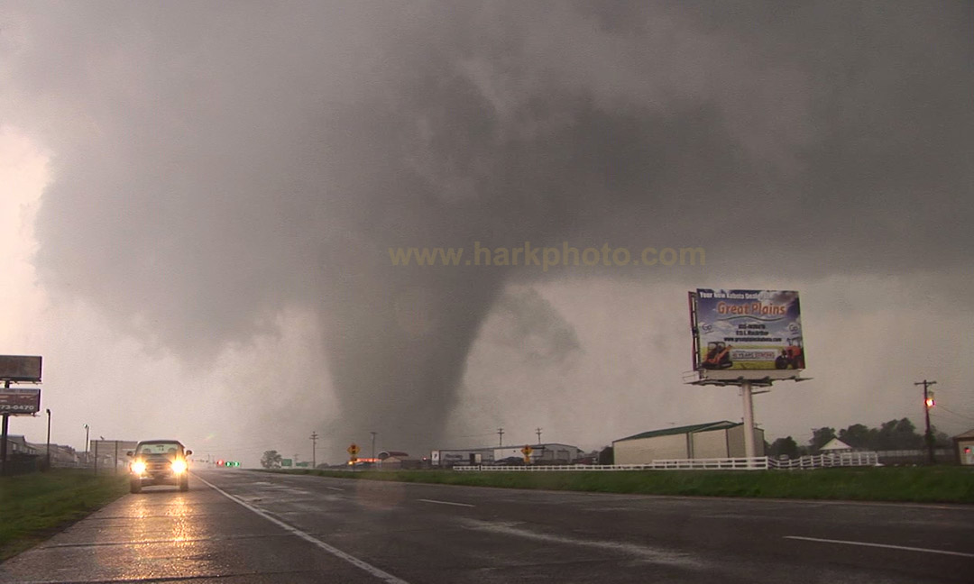
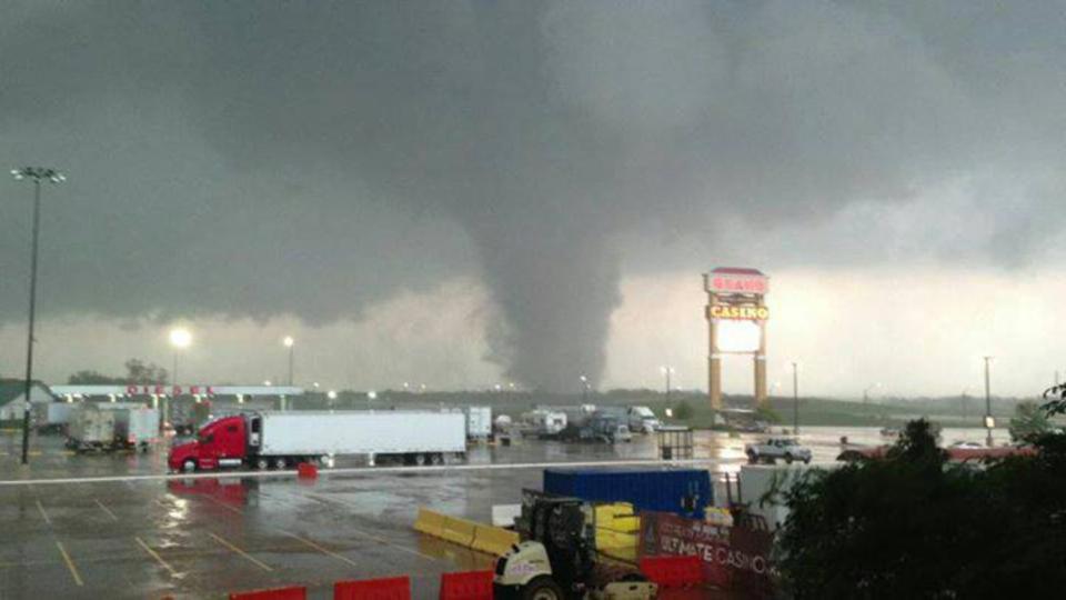
| A deadly EF-4 tornado crosses Highway 177 near Shawnee on May 19, 2013. Photo courtesy Bill Hark. | The same tornado from May 19, 2013 as seen from the Grand Casino near Dale. Photo courtesy Sara Wedersky. |
The dryline pushed eastward the following afternoon, shifting the severe weather threat toward the I-35 corridor. May 19th saw only a few thunderstorms develop along the dryline, but the ones which did develop were intense supercells. Two of these supercells produced tornadoes, some of which were strong and long-track. The first storm dropped an EF-1 tornado in Edmond, followed by a long-track EF-3 from near Luther to east of Carney. Later, another storm which developed southwest of the Oklahoma City metro produced a long-track EF-4 tornado from near Lake Thunderbird to north of Shawnee. This tornado resulted in two fatalities near Shawnee, where the EF-4 damage was found.
 |
| The Moore tornado of May 20, 2013 near Interstate 35. Photo courtesy Gabe Garfield. |
May 20th was the last in a three-day stretch of significant severe weather, and brought the most devastating tornado of the year for Oklahoma. Several supercells once again developed by early afternoon along a dryline in central Oklahoma. One of these storms developed near Chickasha and rapidly intensified, producing a tornado which touched down at 2:56 PM on the west side of Newcastle. The tornado became violent within minutes, then tracked east-northeastward across the city of Moore for about 40 minutes before finally dissipating near Lake Stanley Draper. The Newcastle-Oklahoma City-Moore tornado was rated EF-5 and devastated areas of Moore along its path, with over 20 fatalities. A couple other tornadoes also occurred in Stephens County during the afternoon of May 20.
Several additional episodes of severe weather occurred over the following 10 days in Oklahoma and western north Texas, but it was not until May 31 that another major tornado event struck our region.
 |
 |
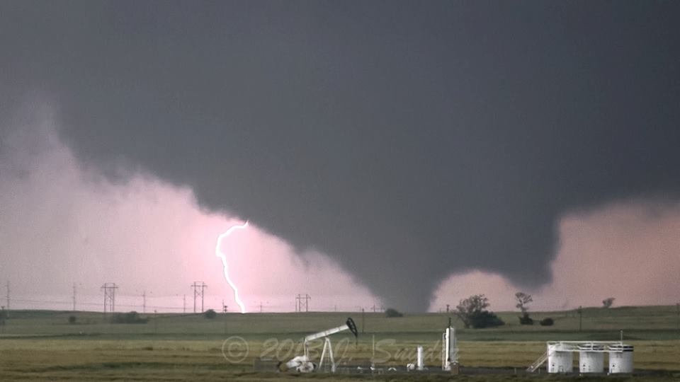
| National Weather Service meteorologists in Norman monitor radar and issue warnings on May 31, 2013. | The El Reno tornado of May 31, 2013. Photo courtesy Jeff Snyder. |
On May 31st, a dryline intersected a warm front near the Oklahoma City metro area yet again, yielding the potential for tornadic thunderstorms. By late afternoon, storms developed 50-75 miles west of the I-35 corridor and began moving east. One supercell storm in Canadian County quickly became dominant and produced a tornado southwest of El Reno at 6:06 PM. Over the following 40 minutes, this tornado became very large, violent, and took an unusual path that "hooked" around El Reno to the west, south, and east (see the graphic on the event page linked above). This tornado was officially rated EF-3 after a damage survey, although mobile radar measured winds in excess of 200 mph just above the ground. It was the widest tornado ever recorded in the United States, with a maximum path width of 2.6 miles near Highway 81. Unfortunately, the El Reno tornado proved to be the third deadly Oklahoma tornado in two weeks, with multiple fatalities in vehicles. Several other tornadoes were reported in and around Oklahoma City through the evening. To add insult to injury, training thunderstorms along the I-40 corridor of central Oklahoma resulted in major flash flooding, which claimed several more lives in the Oklahoma City area.
As the calendar turned to meteorological summer on June 1, the onslaught of severe weather seen in late May ended as abruptly as it had begun. The summer of 2013 differed markedly from the devastating drought and persistent record heat of 2011 and 2012. This year, several bouts of heavy rainfall helped to keep soil moisture high and temperatures mild, especially outside of far western Oklahoma and western north Texas. Oklahoma City had only five days with highs of 100 F or warmer all summer. Wichita Falls, which stayed drier most of the year, had 23 days of 100 F or warmer this summer (plus seven more in September).
With the lack of extreme heat, the main stories through the summer months were periodic severe weather and heavy rainfall. While there were numerous days with scattered large hail and severe wind gusts, along with a few instances of localized flash flooding, none of the events were particularly widespread or high-impact. Oklahoma City recorded 9.84" of rain in the month of July, which is the second most on record since the late 1800s. For comparison, the July rainfall in 2012 was a measly 0.39", less than 5% of this July's total!
A rather long period of fairly tranquil weather was felt from late summer into fall. A handful of severe wind and hail events occurred, but none of these were very widespread nor extreme with mainly quarter size hail and wind gusts ranging from 55 to 65 mph. Otherwise, the main story was the oppressive drought that continued to grip much of southwest Oklahoma and western north Texas in the absence of any meaningful rainfall.
|
After a mild October, November brought a couple early tastes of winter to the southern Plains. A strong cold front that pushed through on November 12 dropped Oklahoma City's low to 19 degrees the following morning. While the week of November 14-20 saw a warmup, a more significant cold front arrived on the 21st, bringing winter precipitation and unseasonably cold temperatures. Oklahoma City experienced two days with high temperatures at or below freezing: November 22nd and 24th. On November 22-23, widespread light sleet and freezing rain affected much of Oklahoma and north Texas, resulting in some moderate ice accumulations. On November 24, more significant precipitation affected western and central Oklahoma in the form of snow. A band of significant accumulations over 4" stretched from near Hollis to north of Lawton, with a maximum of 13" near Vinson. |
 |
Another significant early-season winter storm affected the region with snow and sleet on December 5-6, 2013. The heaviest amounts of 4-6" fell along and just northwest of I-44, from near Altus to the north Oklahoma City metro. An impressive cold spell began during the precipitation and continued for several days afterward, allowing the modest snow cover to stick around for an unusually long period. Oklahoma City's high was in the 20s for four straight days from December 6-9, and below freezing for five straight days (the high on December 5 was 31). With calm winds and snow cover, low temperatures on the morning of December 10 fell below zero across parts of northern and western Oklahoma, while Oklahoma City hit 5 F.
 |
 |
| Total snowfall accumulations from December 5-6, 2013. | Significant accumulation in Quanah, TX, on December 5, 2013. Photo courtesy Bryan Rupp. |
Another winter storm took shape on Friday, December 20th, and lasted through early Sunday morning December 22nd. This storm brought copious amounts of ice to much of central and southwestern Oklahoma, while dumping up to 6 inches of snow across portions of rural northwestern Oklahoma. Up to 0.75 inches of ice accumulation was reported over Canadian and Caddo counties, while much of the rest of central and southwest Oklahoma saw between 0.25 and 0.50 inches. The ice brought down numerous trees and tree limbs and resulted in loss of power in many areas. The event also provided Oklahoma City with enough rain to clench the 2nd wettest year on record.
 |
 |
| Total ice accumulations from December 20-21, 2013. | Total snowfall accumulations from December 21-22, 2013. |
And with the number of winter weather events we saw in December, and the Arctic air masses associated with them, it's no surprise that Oklahoma City wound up 3.9 degrees below normal at 36.7° F for the last month in 2013, which tied 1961 for the 22nd coolest December on record. Similarly, the monthly mean temperature for Wichita Falls was 4.4 degrees below normal at 38.4° F, making it the sixth coolest December on record.
For the third consecutive year, Oklahoma and western north Texas started January in extreme drought. Some improvement was seen for areas near the I-35 corridor during the spring months. In stark contrast to 2011 and 2012, however, it was the summer months which offered the most widespread, beneficial rains. By August, the drought had been (temporarily) eliminated across portions of central Oklahoma and significantly reduced for most of northern and western Oklahoma. Southwest Oklahoma and western North Texas tended to miss out on some of the bigger precipitation events again this year, and have remained in long-term severe to exceptional drought.
The following image is an animated loop of the U.S. Drought Monitor Conditions for the NWS Norman Forecast Area from January through December 2013.

The following image depicts the percent of normal precipitation that had occurred across the NWS Norman forecast area for 2013.
