A dangerous, record heat wave continues across portions of the West through Tuesday. High rip current risk and dangerous surf continue through the weekend. There are flash flooding concerns through the weekend for portions of the Southeast and Southwest. Read More >
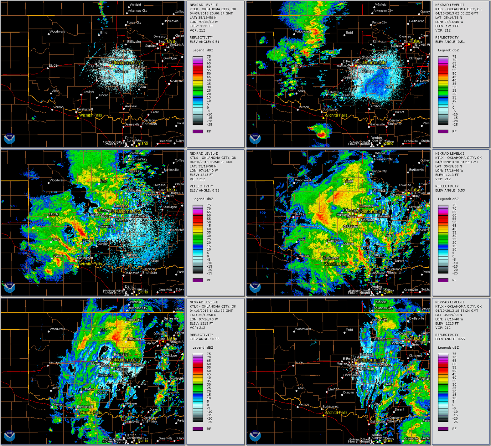
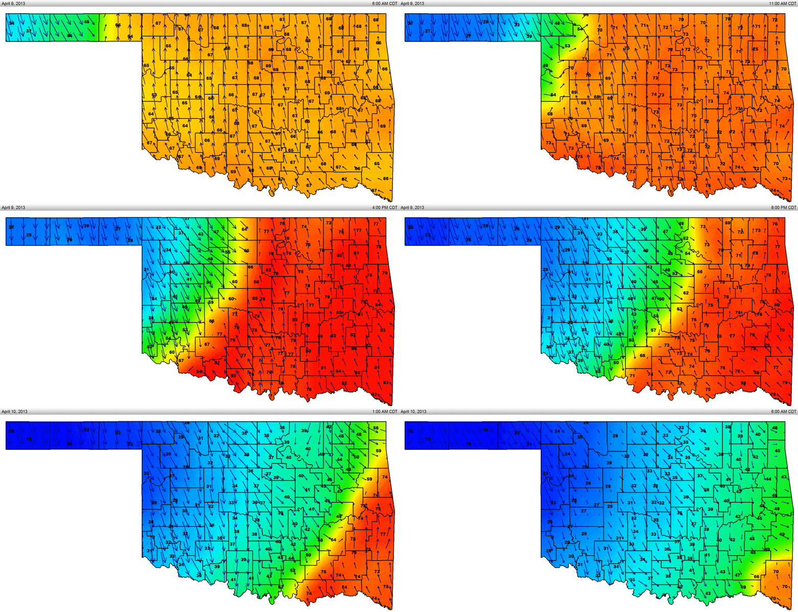
A bi-modal storm system impacted Oklahoma and north Texas from Tuesday April 9th through Wednesday April 10th. Several days of moist southerly flow combined with mainly clear skies lead to ample instability, but a strong capping inversion kept storms from developing much of the day. By mid to late afternoon, an unusually strong, but shallow cold front had moved into central Oklahoma. Temperatures across the front ranged from below freezing over northern and western Oklahoma, to the low 80s over southern and eastern portions of Oklahoma. Despite lift along the front, the capping inversion kept storms from forming. It wasn't until late afternoon and early evening that storms finally developed behind the front in the cold post-frontal air mass. A few isolated storms also formed near the cold front/dryline intersection where convergence was enhanced. With cold temperatures aloft, and very steep lapse rates, large hail was abundant, and several reports of hail exceeding two inches in diameter were received, mainly over portions of western north Texas. A lightning strike from one of the supercells over Archer county Texas near Olney, TX resulted in a tank explosion. Fortunately no injuries were reported.
As the front continued to surge southward, freezing to near freezing temperatures overspread much of western Oklahoma and western north Texas. A potent upper level wave allowed for widespread moderate to heavy rain showers and thunderstorms where surface temperatures were below freezing, generating freezing rain. While not unheard of, freezing rain during April is exceedingly rare in Oklahoma and north Texas. Freezing rain continued into the early afternoon as precipitation finally ended from west to east. Much of western Oklahoma and far western north Texas saw ice accumulations. Fortunately, ground temperatures were relatively warm thanks to several days of temperatures in the 70s and 80s, preventing ice from sticking to roadways. However, ice accumulations of a quarter to a half inch occurred on trees and power lines, resulting in sporadic power outages. this was particularly the case over west central and central Oklahoma. Substantial tree damage also occurred, especially to soft wood trees with increasing leaf canopies due to the recent warmer temperatures.
Freezing rain events are not all that uncommon across Oklahoma and north Texas, especially during the late Winter and early Spring months. However, the late nature of this event does make it stand out. Looking at past events, the latest such freezing rain event that resulted in ice accumulation in Oklahoma City occurred back on April 17-18 of 1953. Northwest Oklahoma, which tends to have a greater frequency of winter weather events, had it's latest freezing rain event in late April 1994 at Gage. While cold fronts of this magnitude certainly bring below average temperatures for a brief time, they cannot accurately foretell what the summer may be like. For instance, the summer of 1953, the year in which Oklahoma City's latest icing occurred, was one of the hottest summers across the Central and Southern Plains on record. What we can say for sure, is that this is an unusually late freezing rain occurrence, and that it likely won't happen again this year. Heading into late April and early May, we are sure to warm up,
 PRELIMINARY LOCAL STORM REPORT...SUMMARY
 NATIONAL WEATHER SERVICE NORMAN OK
 245 PM CDT WED APR 10 2013

 ..TIME...   ...EVENT...      ...CITY LOCATION...     ...LAT.LON...
 ..DATE...   ....MAG....      ..COUNTY LOCATION..ST.. ...SOURCE....
             ..REMARKS..

 0630 AM     FREEZING RAIN    OMEGA                   35.87N 98.20W
 04/10/2013  E0.50 INCH       KINGFISHER         OK   TRAINED SPOTTER

             DOWNED TREES AND SPORADIC POWER OUTAGES ALSO REPORTED.

 0630 AM     FREEZING RAIN    VANCE AIR FORCE BASE    36.34N 97.90W
 04/10/2013  E0.25 INCH       GARFIELD           OK   OTHER FEDERAL

 0700 AM     FREEZING RAIN    CORDELL                 35.30N 98.98W
 04/10/2013  E0.50 INCH       WASHITA            OK   LAW ENFORCEMENT

             1/4 TO 1/2 INCH OF ICE ON TREES, POWER LINES, AND
             VEHICLES.

 0845 AM     FREEZING RAIN    BINGER                  35.31N 98.34W
 04/10/2013  E0.30 INCH       CADDO              OK   LAW ENFORCEMENT

             1/4 TO 1/3 INCH OF ICE ON TREES, POWER LINES, AND
             VEHICLES.

 0845 AM     FREEZING RAIN    HINTON                  35.47N 98.36W
 04/10/2013  E0.25 INCH       CADDO              OK   LAW ENFORCEMENT

             GLAZE TO A QUARTER INCH REPORTED ON ELEVATED SURFACES.

 0848 AM     FREEZING RAIN    EL RENO                 35.53N 97.96W
 04/10/2013  E0.12 INCH       CANADIAN           OK   LAW ENFORCEMENT

 0848 AM     FREEZING RAIN    YUKON                   35.50N 97.74W
 04/10/2013  E0.25 INCH       CANADIAN           OK   UTILITY COMPANY

             1/8 TO 1/4 INCH OF ICE ON TREES, SPORADIC POWER OUTAGES.

 0920 AM     FREEZING RAIN    LAWTON                  34.60N 98.42W
 04/10/2013  E0.25 INCH       COMANCHE           OK   FIRE DEPT/RESCUE

             1/4 INCH OR LESS OF ICE ON TREES AND CARS.

 0920 AM     SNOW             FREEDOM                 36.77N 99.11W
 04/10/2013  E0.5 INCH        WOODS              OK   CO-OP OBSERVER

             MIXED PRECIPITATION REPORTED INCLUDING SLEET, HAIL, AND
             SNOW.

 0920 AM     FREEZING RAIN    WAYNOKA                 36.58N 98.88W
 04/10/2013  E0.25 INCH       WOODS              OK   CO-OP OBSERVER

 0930 AM     FREEZING RAIN    CHEROKEE                36.75N 98.35W
 04/10/2013  E0.25 INCH       ALFALFA            OK   LAW ENFORCEMENT

 0932 AM     FREEZING RAIN    FREDERICK               34.39N 99.01W
 04/10/2013  E0.25 INCH       TILLMAN            OK   FIRE DEPT/RESCUE

             SPORADIC POWER OUTAGES FROM DOWNED TREES.

 0933 AM     FREEZING RAIN    1 SSE HELENA            36.53N 98.26W
 04/10/2013  E0.25 INCH       ALFALFA            OK   CO-OP OBSERVER

 0935 AM     FREEZING RAIN    JEFFERSON               36.72N 97.79W
 04/10/2013  E0.15 INCH       GRANT              OK   CO-OP OBSERVER

 0935 AM     FREEZING RAIN    GREAT SALT PLAINS LAKE  36.74N 98.20W
 04/10/2013  E0.15 INCH       ALFALFA            OK   CO-OP OBSERVER

 0942 AM     FREEZING RAIN    ALTUS                   34.64N 99.33W
 04/10/2013  E0.25 INCH       JACKSON            OK   LAW ENFORCEMENT

 0945 AM     FREEZING RAIN    WATONGA                 35.85N 98.41W
 04/10/2013  E0.25 INCH       BLAINE             OK   CO-OP OBSERVER

 0945 AM     FREEZING RAIN    LAMONT                  36.69N 97.56W
 04/10/2013  E0.15 INCH       GRANT              OK   CO-OP OBSERVER

             1/8 TO 1/16 OF ICE ACCUMULATION REPORTED.

 0945 AM     FREEZING RAIN    5 NE NEWKIRK            36.93N 96.99W
 04/10/2013  E0.05 INCH       KAY                OK   CO-OP OBSERVER

             GLAZE OF ICE ON TREES AND CARS.

 0948 AM     FREEZING RAIN    ELDORADO                34.47N 99.65W
 04/10/2013  E0.25 INCH       JACKSON            OK   FIRE DEPT/RESCUE

 0951 AM     FREEZING RAIN    ANADARKO                35.07N 98.24W
 04/10/2013  E0.05 INCH       CADDO              OK   CO-OP OBSERVER

             GLAZE OF ICE ON TREES AND CARS.

 0951 AM     FREEZING RAIN    FAIRVIEW                36.27N 98.48W
 04/10/2013  E0.25 INCH       MAJOR              OK   LAW ENFORCEMENT

 0951 AM     FREEZING RAIN    MANGUM                  34.88N 99.50W
 04/10/2013  E0.12 INCH       GREER              OK   FIRE DEPT/RESCUE

 0951 AM     FREEZING RAIN    ERICK                   35.21N 99.87W
 04/10/2013  E0.25 INCH       BECKHAM            OK   CO-OP OBSERVER

 0955 AM     FREEZING RAIN    1 SW WALTERS            34.35N 98.32W
 04/10/2013  E0.10 INCH       COTTON             OK   PUBLIC

 0958 AM     FREEZING RAIN    HOLLIS                  34.69N 99.92W
 04/10/2013  E0.10 INCH       HARMON             OK   EMERGENCY MNGR

 1000 AM     FREEZING RAIN    TALOGA                  36.04N 98.96W
 04/10/2013  E0.25 INCH       DEWEY              OK   CO-OP OBSERVER

 1000 AM     FREEZING RAIN    WEATHERFORD             35.53N 98.70W
 04/10/2013  E0.25 INCH       CUSTER             OK   CO-OP OBSERVER

 1002 AM     FREEZING RAIN    PERRY                   36.29N 97.29W
 04/10/2013  E0.05 INCH       NOBLE              OK   CO-OP OBSERVER

             GLAZE OF ICE ON ELEVATED SURFACES.

 1020 AM     FREEZING RAIN    CHILLICOTHE             34.26N 99.51W
 04/10/2013  E0.25 INCH       HARDEMAN           TX   PUBLIC

 1022 AM     FREEZING RAIN    VERNON                  34.15N 99.29W
 04/10/2013  E0.25 INCH       WILBARGER          TX   FIRE DEPT/RESCUE

 1030 AM     FREEZING RAIN    CROWELL                 33.98N 99.72W
 04/10/2013  E0.25 INCH       FOARD              TX   PUBLIC

 1030 AM     FREEZING RAIN    CYRIL                   34.90N 98.20W
 04/10/2013  E0.25 INCH       CADDO              OK   CO-OP OBSERVER

 0134 PM     FREEZING RAIN    3 SSE NORMAN            35.18N 97.42W
 04/10/2013  E0.10 INCH       CLEVELAND          OK   NWS EMPLOYEE

             GLAZE OF ICE ON TREES AND CARS AT THE NWS OFFICE.
PRELIMINARY LOCAL STORM REPORT...SUMMARY
NATIONAL WEATHER SERVICE NORMAN OK
737 AM CDT WED APR 10 2013

..TIME...   ...EVENT...      ...CITY LOCATION...     ...LAT.LON...
..DATE...   ....MAG....      ..COUNTY LOCATION..ST.. ...SOURCE....
            ..REMARKS..

0540 PM     HAIL             3 N RED SPRINGS         33.66N 99.42W
04/09/2013  E1.00 INCH       BAYLOR             TX   CO-OP OBSERVER

0700 PM     NON-TSTM WND GST 3 W MEDICINE PARK       34.73N 98.55W
04/09/2013  M58.00 MPH       COMANCHE           OK   MESONET

0733 PM     HAIL             14 SSW ARCHER CITY      33.41N 98.72W
04/09/2013  E2.75 INCH       ARCHER             TX   TRAINED SPOTTER

0807 PM     HAIL             4 S WINDTHORST          33.52N 98.44W
04/09/2013  M1.75 INCH       ARCHER             TX   TRAINED SPOTTER

0809 PM     HAIL             WINDTHORST              33.58N 98.44W
04/09/2013  E1.00 INCH       ARCHER             TX   TRAINED SPOTTER

0820 PM     HAIL             1 W DEER CREEK          33.63N 98.29W
04/09/2013  E1.00 INCH       CLAY               TX   AMATEUR RADIO

0821 PM     HAIL             VICI                    36.15N 99.30W
04/09/2013  E1.75 INCH       DEWEY              OK   PUBLIC

0821 PM     HAIL             3 E WINDTHORST          33.58N 98.38W
04/09/2013  M2.00 INCH       CLAY               TX   TRAINED SPOTTER

0823 PM     HAIL             VICI                    36.15N 99.30W
04/09/2013  E1.00 INCH       DEWEY              OK   TRAINED SPOTTER

            ALSO FREEZING RAIN.

0829 PM     HAIL             BLUEGROVE               33.67N 98.23W
04/09/2013  E1.00 INCH       CLAY               TX   PUBLIC

0910 PM     NON-TSTM WND GST 3 W MEDICINE PARK       34.73N 98.55W
04/09/2013  M60.00 MPH       COMANCHE           OK   MESONET

0929 PM     HAIL             5 SW DEER CREEK         33.58N 98.34W
04/09/2013  E1.00 INCH       CLAY               TX   TRAINED SPOTTER

0935 PM     HAIL             KAMAY                   33.85N 98.82W
04/09/2013  E1.00 INCH       WICHITA            TX   TRAINED SPOTTER

0952 PM     HAIL             6 SW GRANDFIELD         34.17N 98.76W
04/09/2013  E1.75 INCH       TILLMAN            OK   PUBLIC

1001 PM     HAIL             GRANDFIELD              34.23N 98.69W
04/09/2013  E1.00 INCH       TILLMAN            OK   AMATEUR RADIO

1005 PM     HAIL             GRANDFIELD              34.23N 98.69W
04/09/2013  E1.25 INCH       TILLMAN            OK   AMATEUR RADIO

1005 PM     HAIL             HENRIETTA               33.82N 98.19W
04/09/2013  E0.75 INCH       CLAY               TX   AMATEUR RADIO

1046 PM     HAIL             5 N ALTUS               34.71N 99.33W
04/09/2013  E0.88 INCH       JACKSON            OK   AMATEUR RADIO

            HAIL COVERAGE WAS REPORTED TO BE 1.5 INCHES DEEP.

1100 PM     HAIL             ALTUS AIR FORCE BASE    34.66N 99.29W
04/09/2013  E0.75 INCH       JACKSON            OK   TRAINED SPOTTER

1125 PM     HAIL             HYDRO                   35.55N 98.58W
04/09/2013  E0.25 INCH       CADDO              OK   LAW ENFORCEMENT

1125 PM     NON-TSTM WND GST 3 W MEDICINE PARK       34.73N 98.55W
04/09/2013  E62.00 MPH       COMANCHE           OK   MESONET

1155 PM     HAIL             BENJAMIN                33.58N 99.79W
04/09/2013  E1.00 INCH       KNOX               TX   COUNTY OFFICIAL

1230 AM     NON-TSTM WND GST 3 W MEDICINE PARK       34.73N 98.55W
04/10/2013  M59.00 MPH       COMANCHE           OK   MESONET

1245 AM     HAIL             1 SW VERNON             34.14N 99.30W
04/10/2013  E0.50 INCH       WILBARGER          TX   AMATEUR RADIO

1256 AM     HAIL             5 N MEDICINE PARK       34.80N 98.50W
04/10/2013  E1.00 INCH       COMANCHE           OK   BROADCAST MEDIA

The above animation shows radar reflectivity from 3 pm CDT on the 9th to 2 pm CDT on the 10th. Initially, isolated severe storms can be noted, with a transition to more widespread showers and storms as the loop progresses.

The animated GIF above shows the evolution of the cold front across Oklahoma from 6:00 AM CDT on the 9th, to 6:00 AM CDT on the 10th.