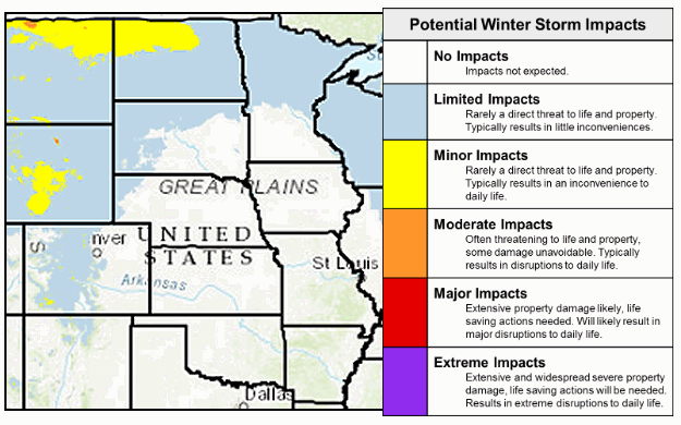
 |
| For Your Information |
| If there is something that may be of interest to you, we will try to make that information available. |
|
|
 |
Winter Weather Awareness Week |
 |
| |
| Introduction |
| |
|
Winter can bring a variety of conditions, including heavy snow, ice, and cold temperatures. These conditions can make driving conditions hazardous, with power outages occurring at times. In the end, you may become exposed to the elements...with your life threatened.
To help the citizens of Arkansas prepare for these conditions, a special week has been set aside to review safety rules and to understand the hazards of winter. This year, Winter Weather Awareness Week runs from November 30 to December 6, 2025.
|
| Important Information |
| |
 |
| In the picture: Winter Weather Awareness Week is a joint effort between the National Weather Service and several partners across Arkansas including the Division of Emergency Management, the Department of Transportation, and the Department of Education. Click to enlarge. |
|
| |
|
The National Weather Service (NWS) will transmit winter weather safety information every day during this special week. You can acquire this information on NOAA Weather Radio All Hazards and the internet.
|
| Information Sent During Winter Weather Awareness Week, 2025 |
| |
| Sunday, November 30, 2025...Introduction...click here. |
| Monday, December 1, 2025...Outlook for the Upcoming Winter...click here. |
| Tuesday, December 2, 2025...Winter Precipitation Types...click here. |
| Wednesday, December 3, 2025...Winter Weather Watches, Warnings and Advisories...click here. |
| Thursday, December 4, 2025...Winter Weather Safety Rules...click here. |
| Friday, December 5, 2025...The Cold of Winter...click here. |
| Winter Forecast |
| |
|
|
Temperature Outlook | Precipitation Outlook
Weak La Niña |
| In the pictures: Given a weak La Niña (cooler than normal water by at least 0.5°C along the equator in the Pacific Ocean), confidence is highest in a warmer and drier than normal winter (December, 2024 through February, 2025) across much of the southern United States. The graphics are courtesy of the Climate Prediction Center and the International Research Institute for Climate and Society/Columbia University. |
|
| |
|
One of the most reliable long-range predictors deals with monitoring water temperatures along the equator in the Pacific Ocean. If the water cools, we trend toward La Niña. If warming occurs, then it's El Niño. Both variables have a say in how the weather behaves across the country, especially when they become dominant. In the coming months, it appears the pendulum will swing weakly toward La Niña, which favors colder/wetter than usual conditions across the northern states this winter, and a warmer/drier scenario farther south.
|
| What It Means For Arkansas |
|
Confidence is swayed toward above average temperatures this winter locally. That does not mean it will be mild the entire three month period (December through February). Instead, it is implied that rounds of cold air will be fewer than in a typical winter.
The same rationale applies to the precipitation outlook. The forecast is leaning toward a drier than normal winter, especially in southern sections of the state. While there will be wet periods (and chances of wintry precipitation if cold air is in place), big slugs of moisture should be less than usual. As a side note, the degree of wetness will dictate how an ongoing drought improves or worsens moving forward. This will be evaluated more closely as winter progresses.
|
|
It must be mentioned that the most recent huge episodes of snow, ice, and severe thunderstorms occurred with La Niña in control. However, confidence in extreme weather this winter is low given that La Niña will not be strong and may be short-lived.
|
| Beware La Niña |
|
With La Niña taking charge, the largest tornado outbreak in Arkansas took place in January of 1999. There were 56 tornadoes spawned. In December of 2000, two crippling ice storms occurred, and remain one of the largest natural disasters in state history. In February of 2008, a tornado tracked 122 miles through seven counties in the north and west. This was a record long track in the state. Another devastating ice storm hit the north in January of 2009. Finally, one to two feet of snow buried the Ozark Mountains in February of 2011. In April and May, an astonishing 67 (of the yearly total of 75) tornadoes were counted. There was also record flooding along the Black and lower White Rivers.
During several of these historic events, La Niña was strong (water temperatures were more than 1.5°C below normal). Since early 2012, La Niña has largely been infrequent and weak.
|
|
Regardless of the phase (El Niño/La Niña), winters have tended to be more mild/wet than cold/dry since 2000. There was a surplus of precipitation by at least two inches in nine of the last twenty five winters. By comparison, precipitation deficits of two inches or more occurred a little less often (six times).
|
| Precipitation During Last 25 Winters in Arkansas |
| Departure From Normal |
Winters Above Average |
Winters Below Average |
| At Least 1" |
10 |
8 |
| At Least 2" |
9 |
6 |
| At Least 3" |
6 |
2 |
|
As far as temperature, readings were at least two degrees warmer than average more than half the time (thirteen winters), and two degrees or more subpar on only three occasions.
|
| Temperatures During Last 25 Five Winters in Arkansas |
| Departure From Normal |
Winters Above Average |
Winters Below Average |
| At Least 1° F |
12 |
7 |
| At Least 2° F |
12 |
3 |
| At Least 3° F |
9 |
3 |
|
Since La Niña is expected to be somewhat underwhelming this winter, the weather pattern may be governed at times by other variables such as the Arctic Oscillation (AO).
|
|
In the strongly negative phase of the AO, pressure is higher toward the North Pole, and this sets up a blocking pattern. Cold air traversing Canada is forced to the south, and our temperatures drop.
|
 |
In the winter of 2010/2011, there was a long term negative AO, and that led to one cold blast after another. On February 9th, 2011, one to two feet of snow blanketed the Ozark Mountains. Six to eight inches of powder accumulated in the Little Rock (Pulaski County) area. It was a top ten snowy winter locally. Such a lengthy negative AO is rare. Usually, AO phases are of short duration (days to weeks), and are tricky to forecast compared to a much more stable El Niño/La Niña (months). |
| In the picture: One to two feet of snow piled up in northwest Arkansas on 02/09/2011. |
| Long Term Strongly Negative AO Occurrences |
|
Since 2000, the AO dropped below -1.5 (strongly negative) for two or more consecutive months only five times. Two of these instances were less than a year apart (December, 2009 to February, 2010 and December, 2010/January, 2011). The next time it happened was ten years later (December, 2020/January, 2021).
|
 |
| In the picture: Subfreezing temperatures were noted all the way into south Texas as of 200 pm CST on 02/15/2021. Readings were below zero as far south as Kansas and Missouri. |
|
| |
|
There was another Arctic intrusion in February, 2021. This time, the heaviest snow (more than twenty inches in places) was in central and southern Arkansas from the 14th through the 18th. In happened in less than a week, and was courtesy of two big storm systems traversing the southern United States. Temperatures during this time frame were twenty to more than thirty degrees below normal.
|
 |
| In the picture: Tornadoes in Arkansas (2000 to 2023). Of the 919 tornadoes spawned in this twenty four year period, 346 tornadoes (37.6%) occurred in the fall/winter (September through February). |
|
| |
|
One other thing to consider is severe weather. Although most people associate the spring months with severe storms, Arkansas is no stranger to tornadoes in the fall and winter. In fact, almost four of ten tornadoes from 2000 to 2023 occurred between September and February.
|
| Cold Weather Headlines |
| |
| WIND CHILL INDEX °F |
| |
WIND SPEED (MPH) |
| TEMP (°F) |
5 |
10 |
15 |
20 |
25 |
30 |
35 |
40 |
| -25 |
-40 |
-47 |
-51 |
-55 |
-58 |
-60 |
-62 |
-64 |
| -20 |
-34 |
-41 |
-45 |
-48 |
-51 |
-53 |
-55 |
-57 |
| -15 |
-28 |
-35 |
-39 |
-42 |
-44 |
-46 |
-48 |
-50 |
| -10 |
-22 |
-28 |
-32 |
-35 |
-37 |
-39 |
-41 |
-43 |
| -5 |
-16 |
-22 |
-26 |
-29 |
-31 |
-33 |
-34 |
-36 |
| 0 |
-11 |
-16 |
-19 |
-22 |
-24 |
-26 |
-27 |
-29 |
| 5 |
-5 |
-10 |
-13 |
-15 |
-17 |
-19 |
-21 |
-22 |
| 10 |
1 |
-4 |
-7 |
-9 |
-11 |
-12 |
-14 |
-15 |
| 15 |
7 |
3 |
0 |
-2 |
-4 |
-5 |
-7 |
-8 |
| 20 |
13 |
9 |
6 |
4 |
3 |
1 |
0 |
-1 |
| 25 |
19 |
15 |
13 |
11 |
9 |
8 |
7 |
6 |
| 30 |
25 |
21 |
19 |
17 |
16 |
15 |
14 |
13 |
| 35 |
31 |
27 |
25 |
24 |
23 |
22 |
21 |
20 |
| In the table: The wind chill index is determined by combining the temperature and wind speed. Given a temperature, the wind chill index will decrease as the wind strengthens. |
|
| |
|
Have you noticed that it feels colder on a winter day when the wind is blowing? This is not your imagination. On a 30 degree afternoon, if there is a 20 mph sustained wind, it feels like 17 degrees to exposed skin. This apparent temperature is the Wind Chill Index, and it can be dangerous as values approach 0 degrees. What if the wind was removed? An ambient temperature of 0 degrees is just as dangerous given calm conditions.
|
|
When temperatures and/or wind chill index values reach at least 0 degrees over northern/central Arkansas, 5 degrees in southern/east central sections, and 10 degrees in the southwest and far southeast, the National Weather Service will usually issue a Cold Weather Advisory.
When temperatures and/or wind chill index values reach at least -10 degrees over northern/central Arkansas, -5 degrees in southern/east central sections, and 0 degrees in the southwest and far southeast, an Extreme Cold Warning may be posted.
These headlines replace Wind Chill Advisories and Wind Chill Warnings, and are made available so people can adequately prepare for the elements. This includes wearing several layers of loose-fitting, light-weight clothing. The layers actually trap warm air, and keep the cold air out. In addition to a coat and scarf, a hat and mittens are recommended (since more than half of your body's heat escapes through your head and hands).
|
| Updated Heavy Snow Criteria (2023) |
| |
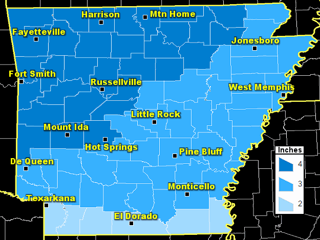 |
| In the picture: Heavy snow criteria per event (up to 48 hours) in Arkansas. |
|
| |
|
Warning criteria thresholds for heavy snow have been updated and simplified nationwide (2023). The updates were made to improve decision support services, collaboration between NWS offices, and communication to customers and partners. Non-meteorological discontinuities were removed to facilitate consistent hazard messaging and headlines. In addition, the criteria is now event based (up to 48 hours) and not tied to 12 or 24 hour periods.
In Arkansas, heavy snow is defined as two inches of accumulation during an event toward the Louisiana border, three inches in southern, central, and eastern sections of the state, and four inches in the north and west (including the Ozark and Ouachita Mountains).
|
 |
| In the picture: Three day Winter Storm Severity Index (WSSI) through 1200 pm CST on 11/20/2019. Limited to minor impacts were expected in the northern and central Rockies, the northern Plains, and the upper Midwest. |
|
| |
|
The underlying basis of the new criteria is a climatological dataset used by the Winter Storm Severity Index (WSSI). This is a tool that enhances communication regarding an event's expected severity. The WSSI provides winter storm impact information out to 72 hours.
|
| Big Winter Events |
| |
 |
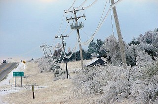
| In the picture: There were ruts in a few neighborhood roads in Sherwood (Pulaski County) to start the morning on 12/26/2012. Otherwise, most roads were snow covered and hazardous. Click to enlarge. |
|
 |
| In the picture: Along U.S. Highway 167 to the south of Cave City (Sharp County), there was ice on the lines and some snow on the ground on 01/28/2009. Click to enlarge. |
|
| |
|
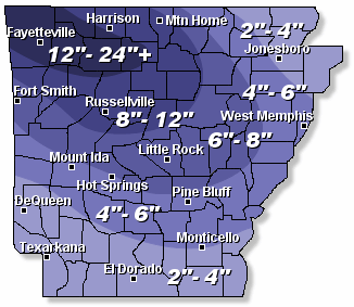
Most winters in Arkansas feature temperatures that fluctuate (sometimes wildly) and periodic rounds of precipitation. If cold air arrives, and sticks around as moisture increases, that is when big snow or ice storms often unfold. Major winter events have affected Arkansas in recent years. On Christmas in 2012, much of the region was buried under a thick blanket of heavy snow, with accumulations over a foot in some areas. At Little Rock (Pulaski County), 10.3 inches of snow piled up. The last time it snowed (more than a trace) in the city on Christmas was 1926! In late January, 2009, one to two inches of freezing rain (and locally more) accrued on trees and power lines in roughly the northern two rows of counties. More than 300,000 utility customers lost power. Tree damage was extensive, and at least 30,000 power poles were downed or snapped.
|
| Precipitation Types |
| |
 |
| Winter Precipitation Types | Example of an Icy Episode (02/11/2021) |
| In the pictures: In Arkansas, it is not uncommon for subfreezing conditions to arrive from the north, and then warm/moist air tries to build into the state from the Gulf Coast before the cold air retreats. That is a recipe for a wintry mess. Clouds and precipitation often result, with snow where cold air is deepest, and rain where it is shallow. Sleet and freezing rain are found somewhere in-between, which was the case on 02/11/2021. On that day, temperatures aloft (between 1000 and 2000 feet) were in the 40s, and this melted snowflakes. Readings were below freezing near the ground (below 1000 feet), and this led to an ice storm. |
|
| |
|
Forecasting precipitation types in Arkansas is challenging. When cold air dives southward from Canada, it is usually shallow by the time it reaches us. Think of it as an upside down bowl of subfreezing conditions, and we are toward the southern edge of the bowl. If temperatures are above freezing over the bowl, and there is precipitation falling, there will likely be melting followed by refreezing. This is a typical ice (freezing rain or sleet) scenario. If the edge of the bowl extends all the way into the clouds, and no warm layer exists, then melting would not occur and here comes the snow!
|
| Watches, Warnings, and Advisories |
| |
|
|
| In the picture: Winter weather headlines were posted for the deep south as of 315 pm CST on 02/14/2021. |
|
| |
|
When a winter event is on the horizon, the National Weather Service will usually have a headline in place. There could be a Watch followed by a Warning and/or Advisory, but what does it mean?
If there is a possibility of heavy snow and/or ice, a Winter Storm Watch will be issued. In the Little Rock County Warning Area, this would be at least three to four inches of snow per event (up to 48 hours), a quarter inch or more of freezing rain, and/or a half inch of sleet or more. If the heavy snow and/or ice becomes imminent, a Winter Storm Warning or Ice Storm Warning will be posted. On very rare occasions, it there is a lot of wind (at least 35 mph), and blowing/drifting snow creates very low visibility (less than a quarter mile), a Blizzard Warning will go out. Anything less than warning criteria will be a Winter Weather Advisory.
|
| Check the Roads |
| |
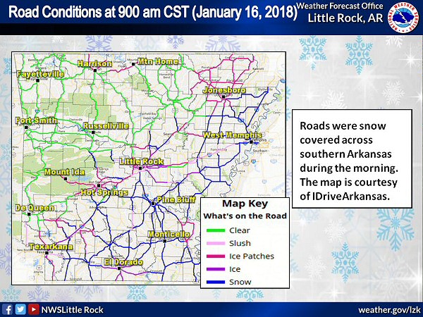 |
| In the picture: Roads were snow and slush covered in much of southern and eastern Arkansas at 900 am CST on 01/16/2018. The image is courtesy of IDriveArkansas. |
|
| |
|
Following a winter event, sometimes it is not a good idea to venture out onto the roads. From a safety standpoint, you are putting yourself at risk of having an accident. Also, you may get in the way of crews trying to treat and clear the roads. If you must drive, please slow down and take it easy! Before you start the vehicle, check the roads at IDriveArkansas. Maps are available to show the status of major thoroughfares; that is; what is on the pavement (such as snow, ice/ice patches, or slush) and how much (such as mostly clear, partly covered, or covered). This information is updated often, especially when there is wintry precipitation.
|
| Links of Interest |
What is on the Road? (examples: clear, slush, ice patches, ice, snow)
Note: When there are issues on the roads, click on affected routes(s) for more information (such as extent of route covered by snow/ice). |
| Understanding Route Conditions (interpreting snow/ice coverage on roads) |
|


