 |
| Storm Reports |
| Are you interested in what happened during a recent event? Check out the report below. |
|
|
 |
Very Cold/Light Snow on January 18-22, 2025 |
 |
| |
|
|
| |
|
As mid-January rolled around, the coldest air of the season was on the horizon. The brunt of the Arctic blast was set to arrive on the 20th/21st. While there was promise of a winter storm, data showed heavy snow staying to the south of Arkansas. This event proved to be historic.
|
|
|
| |
|
We did not miss out on snow entirely. On the leading edge of the Arctic blast, a band of light snow set up over the Ozark Mountains (toward the Missouri border) late on the 18th/early on the 19th. Mountain Home (Baxter County) picked up two inches of accumulation, with an inch at Bellefonte (Boone County), Bruno (Marion County), Gassville (Baxter County), Glencoe (Fulton County), Harrison (Boone County), Pineville (Izard County), Poughkeepsie (Sharp County), and Wheeling (Fulton County).
|
 |
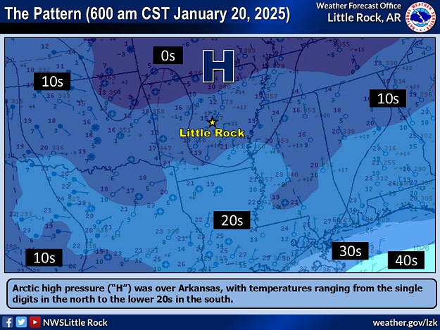
| In the picture: Arctic high pressure ("H") was over Arkansas, with temperatures ranging from the single digits in the north to the lower 20s in the south at 600 am CST at 01/20/2025. |
|
| |
|
By the morning of the 20th/21st, multiple locations in the north had temperatures in the single digits. The lowest readings in this two day period included 1 degree at Compton (Newton County), 3 degrees at Horseshoe Bend (Izard County), Mountain Home (Baxter County), Salem (Fulton County), and Winslow (Washington County), 4 degrees at Hardy (Sharp County), Harrison (Boone County), and Lead Hill (Boone County), and 5 degrees at Mammoth Spring (Fulton County).
There was also a little more snow during this time frame. This time, some locations in central/southern Arkansas got flakes and up to a dusting of accumulation.
|
 |
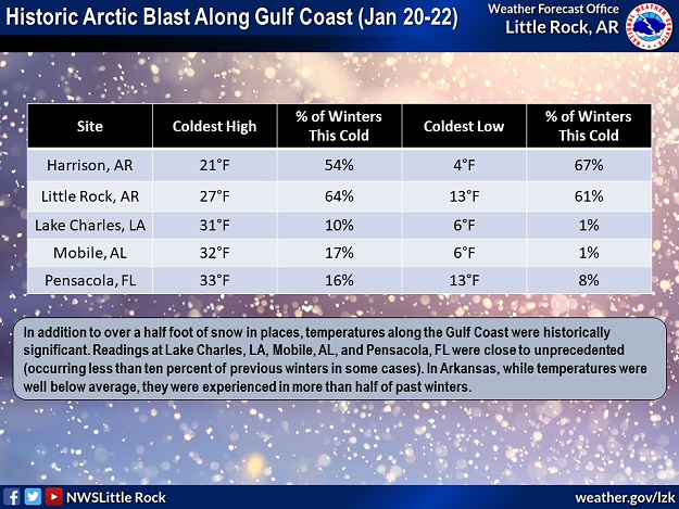
| In the picture: Coldest high/low temperatures on January 20-22, 2025 along the Gulf Coast were historic, with readings that rarely occur. While readings in Arkansas were well below average, they were experienced in more than half of past winters. |
|
| |
|
From an historic perspective, while temperatures across the state were certainly chilly (below average by 15 to 25 degrees), they did not make it into the record books. That was not the case along the Gulf Coast where cold and snow were nearly unprecedented.
|
| A Cold January |
|
Given colder than usual conditions during this event and in the days surrounding a winter storm on January 9th/10th, temperatures were roughly six degrees below average statewide through the 22nd. This was a huge departure from the mild weather experienced in December, 2024 (temperatures more than four degrees above average).
|
|
|
| In the picture: Modern snowfall records were shattered at New Orleans, LA on 01/21/2025. The city was buried under 8.0 inches of snow, which was well above the record 2.7 inches in December, 1963. The information is courtesy of the National Weather Service in New Orleans/Baton Rouge, LA via X (formally Twitter). |
|
| |
|
More than a half foot of snow piled up at Baton Rouge, LA (7.6 inches), Mobile, AL (7.5 inches), and Pensacola, FL (8.9 inches) on the 21st/22nd. All-time snow records were shattered at these sites.
|
|
|
| In the video: A very rare/historic heavy snow event caused accidents in the Pensacola, FL area on 01/21/2025. The video is courtesy of the Florida Department of Transportation via X (formally Twitter). |
|
| |
|
By the morning of the 22nd, Lake Charles, LA and Mobile, AL had a low temperature of only 6 degrees! It had not been this cold at the former location since February, 1899 (3 degrees). At the latter location, while it was colder in January, 1985 (3 degrees), it was another eighty six years (February, 1899) before this feat was duplicated (-1 degree).
|
|
|
| In the picture: There was a swath of heavy snow from the Gulf Coast to the Carolinas in the forty eight hour period ending at 600 am CST on 01/23/2025. |
|
| |
|
The heavy snow band extended from Houston, TX eastward to New Orleans, LA, Albany, GA, and on into the Carolinas. Snow totals from three inches to a foot were common.
|
| Fires in Southern California |
|
As this event concluded, fires had burned in the Los Angeles, CA area for at least two weeks. Three fires over ten thousand acres (Eaton, Hughes, and Palisades fires) were the result of very dry conditions (only 0.16 inch of rain since the beginning of October, 2024/more than six inches below average), a worsening drought, and 60 to 80 mph Santa Ana wind gusts (to fan the flames). The fires were responsible for mass evacuations (over 200,000 people), torching at least 15,000 structures, and 28 fatalities (according to media sources).
|
|
|