National Weather Service United States Department of Commerce
Monthly Storm Reports and Storm Data
Storm Reports
Are you interested in what happened during a recent event? Check out the report below.
 
January, 2025 Monthly Summary
 
Monthly Statistics
 
  Temperatures Precipitation
Site Max Min Avg Norm Dep Hi Lo Sum Norm Dep
Fayetteville (NW AR) 45.2 21.7 33.5 36.4 -2.9 67 7 1.77 2.75 -0.98
Harrison (NC AR) 43.1 24.3 33.7 37.0 -3.3 67 4 2.78 2.67 +0.11
Jonesboro (NE AR) 42.5 27.6 35.1 38.7 -3.6 63 10 5.43 3.52 +1.91
Fort Smith (WC AR) 47.3 25.8 36.6 40.4 -3.8 62 13 2.93 2.91 +0.02
Little Rock (C AR) 47.7 27.4 37.5 40.7 -3.2 66 13 3.53 3.50 +0.03
Texarkana (SW AR) 53.7 33.0 43.4 44.6 -1.2 69 19 3.96 3.64 +0.32
El Dorado (SC AR) 51.7 28.4 40.1 44.7 -4.6 72 12 3.34 4.39 -1.05
Pine Bluff (SE AR) 49.0 30.4 39.7 42.8 -3.1 72 15 2.34 3.82 -1.48


Monthly temperatures were generally well below normal while rainfall totals varied across the state.


Record Temperatures
 
Low temperature records broken in January. Check out the records below.


Site Record Low (Date of Occurrence)
Hot Springs 13 (1/22)
North Little Rock 15 (1/22)
Stuttgart 16 (1/22) 
 
 
Quick Event Summary
 

January was an active month with more than a few rounds of winter weather along with a few thunderstorms. The first tornado of the year occurred on the 5th, it was an EF1 tornado in Lincoln County. A winter storm impacted much of the state January 9th and 10th. Some heavy rain occurred as well, especially later in the month.


Near to above normal temperatures were in place at the start of the month across much of the state. Temperatures warmed dramatically on the 5th as a warm front lifted north across the state. On the 5th a strong storm system approached and began to move across the state with some rain and thunderstorms seen across much of the state. The severe weather threat associated with the storm system was confined to portions of central, southern and eastern Arkansas. Activity moved east of the MS River by the evening hours. Behind the storm system much colder air blew in from the west with gusty winds and rapidly cooling temperatures on the 5th and 6th. Some light snow occurred across northern Arkansas into the 6th with flurries being a little more widespread. 


Temperatures remained cold for several days before another storm system approached from the SW. This brought widespread snow to the northern half to two thirds of the state and sleet/freezing rain to parts of southern AR on the 9th and 10th.

 
Link of Interest
January 9-10, 2025 (Winter Storm)
 

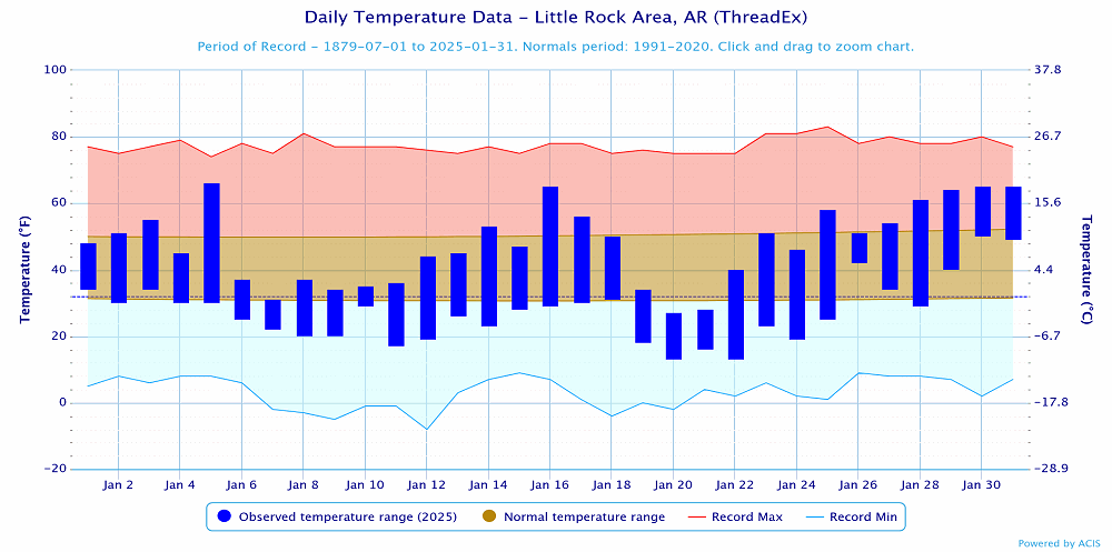
Snow remained on the ground for over a week in a lot of places, especially on north facing slopes and in shaded areas. Some light rain occurred on the 17th with warmer temperatures seen from January 14-17.

Much colder air came into the state on the 18th with cold northerly winds seen through the day and night. A weak system moved through from the evening of the 18th into the early morning hours of the 19th. This brought some light snow to northern parts of the state with as much as 2 inches noted around Mountain Home. 

Another weak system and front moved across the state from the 20-21 with some flurries noted across much of the state. A dusting of snow was seen in a few spots, including portions of Boone and Newton Counties. 

 
Link of Interest
January 18-22, 2025 (Light Snow/Very Cold)
 

Warmer temperatures were seen across the state through the 26th with dry conditions persisting through the 25th. On the 26th a weak system moved through and provided light rain to much of the southern half of the state. A few spots across mainly northwest Arkansas saw a little bit of sleet as well.


Temperatures warmed and mostly dry conditions were seen from the 27th through the 29th. As a slow moving upper level storm system approached from the SW, light rain began to spread from SW to NE across the state during the afternoon and evening of the 29th. More widespread rain and thunderstorms moved across the state during the overnight hours of the 29th into the 30th. Some locations picked up very heavy rainfall. Rain and storms moved east of the state by the late evening hours of the 30th. Dry air and above normal temperatures were seen in the wake of the storm system.  

 
Link of Interest
January 29-30, 2025 (Flooding Rain)
 
Temperatures at Little Rock (Pulaski County).
In the picture: Temperatures at Little Rock (Pulaski County). Click to enlarge.


Precipitation at Little Rock (Pulaski County).
In the picture: Precipitation at Little Rock (Pulaski County). Click to enlarge.


Precipitation across Arkansas.
In the picture: Precipitation across Arkansas.


Link of Interest
Detailed Monthly Statistics