 |
| Storm Reports |
| Are you interested in what happened during a recent event? Check out the report below. |
|
|
 |
Winter Storm on January 9-10, 2025 |
 |
| |
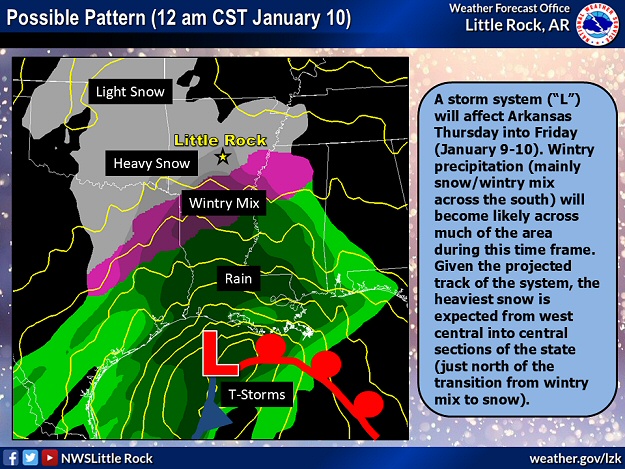 |
| In the picture: A storm system ("L") tracking along the Gulf Coast pumped moisture northward into colder air in Arkansas at 1200 am CST on 01/10/2025. Heavy snow fell across northern and central sections of the state, with a wintry mix (and an ice storm in places) farther south. |
|
| |
|
After watching snow pile up in areas just to the north of Arkansas on January 4th/5th, a winter storm was set to unleash plenty of frozen precipitation across much of the state on the 9th/10th.
|
 |
| Temperatures/Weather at 200 am CST (01/10) | Road Conditions at 115 am CST (01/10) |
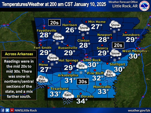
| In the pictures: At 200 am CST on 01/10/2025, temperatures were in the mid 20s to mid 30s, with snow falling across the northern half of Arkansas, and a mix of sleet, freezing rain, and rain across the southern counties. Road conditions reflected the weather conditions, with snow covered roads in northern/central sections of the state, and patchy ice farther south. |
|
| |
|
The region already had cold air in place, and it was a matter of how much moisture would be available. Plugging in as much as one to one and a half inches of liquid, and figuring on a roughly 10 to 1 snow to liquid ratio, parts of Arkansas were in for more than a foot of heavy wet snow.
Snow began across the western counties during the late morning of the 9th, and made it into central sections of the state including the Little Rock (Pulaski County) area between 200 pm and 300 pm CST. Nothing fell from the sky in the northeast until very late on the 9th/the wee hours of the 10th.
|
|
|
| In the video: There was a line of traffic for hours along Interstate 30 due to an accident involving multiple trucks near Malvern (Hot Spring County) on 01/09/2025. The video is courtesy of Brian Emfinger via X (formally Twitter). |
|
| |
|
Roads become snow covered and hazardous across the northern and central counties. Close to Malvern (Hot Spring County), multiple trucks were involved in an accident along Interstate 30, and this tied up traffic for hours.
|
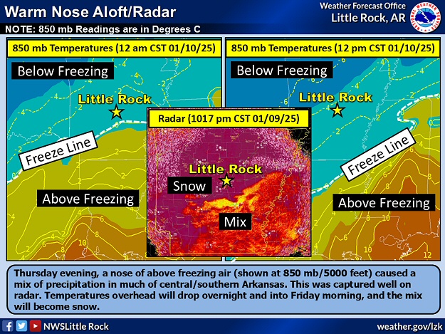 |
| In the picture: A nose of above freezing air was found mainly south of Little Rock (Pulaski County) at 1200 am CST on 01/10/2025. Snow falling into this "warm layer" melted and turned into sleet and freezing rain near the ground. This was captured well by the WSR-88D (Doppler Weather Radar) Correlation Coefficient (CC) product, with a unform purple color where snow was occurring, and a yellow/orange hue representing a wintry mix. Temperatures cooled aloft as the morning progressed, and the mix eventually became snow. |
|
| |
|
Farther south, temperatures aloft climbed above freezing. The chances of snow dwindled (due to melting), and probabilities of ice increased as liquid precipitation encountered subfreezing conditions near the ground. This "warm layer" (almost 6,000 feet deep at Shreveport, LA) managed to reach the central third of Arkansas during the evening of the 9th, and there was a brief period of sleet experienced (instead of all snow).
|
| Sounding at Shreveport, LA (600 pm CST January 9, 2025) |
| Height |
Temperature |
| Ground |
33F |
| 1,400 Feet |
28F |
| 3,000 Feet |
31F |
| 4,400 Feet |
29F |
| 5,700 Feet |
37F |
| 7,600 Feet |
38F |
| 9,400 Feet |
36F |
| 11,700 Feet |
30F |
| 13,800 Feet |
23F |
| Note: The "warm layer" (temperatures above freezing/in yellow above) was almost 6,000 feet deep (from 5,000 feet to 11,000 feet). |
 |
| Snow/Ice Totals | Liquid Precipitation |
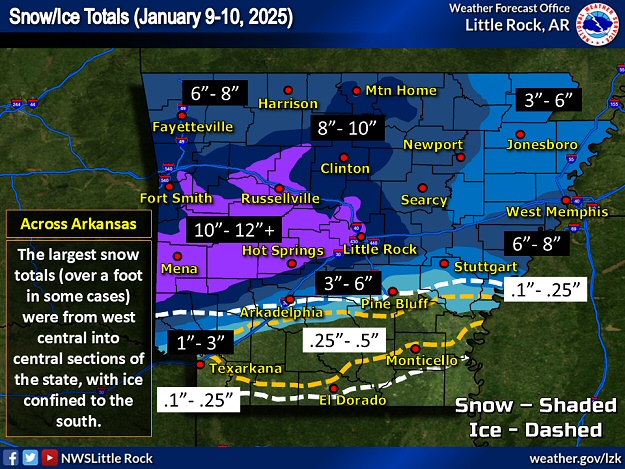
| In the pictures: Snow and ice totals on January 9-10, 2025. Where the heaviest snow (10" to 12"+) occurred from west central into central Arkansas, liquid precipitation averaged 1" to 1.5". |
|
| |
|
By the time the event was over, the northern half of the state was buried under six to more than twelve inches of snow. Briggsville (Yell County) and Mena (Polk County) racked up an impressive 14 inches of accumulation! At the latter location, the cooperative observer reported 13 inches on the 9th, which was the highest one day total locally since records began in the late 1800s.
|
|
|
| In the video: This boxer experienced snow for the first time in Sherwood (Pulaski County) during the morning of 01/10/2025. Instead of being tentative, the dog ran around the backyard and played in about ten inches of accumulation. |
|
| |
|
Just south of Lake Hamilton (Garland County) and at Potter Junction (Polk County), 13 inches of snow was measured. There was a foot of snow at Bonnerdale (Hot Spring County), Lonsdale (Garland County), Ola (Yell County), Perryville (Perry County), and Silver (Montgomery County), and 11 inches of powder at Hot Springs (Garland County), Mount Ida (Montgomery County), Newhope (Pike County), Queen Wilhelmina State Park (Polk County), and Rover (Yell County).
|
|
|
| In the picture: This mesoscale discussion (courtesy of the Storm Prediction Center) expressed concern about freezing rain in southern Arkansas through the early morning hours of 01/10/2025. |
|
| |
|
Meanwhile, there was an ice storm (accruals at least a quarter inch) in parts of the south. Freezing rain coated exposed surfaces such as trees and power lines, and this led to power outages. Locales with this much ice included Ashdown (Little River County), Glendale (Lincoln County), Hampton (Calhoun County), Lewisville (Lafayette County), Magnolia (Columbia County), and Prescott (Nevada County).
|
|
|

