|
| Storm Reports |
| Are you interested in what happened during a recent event? Check out the report below. |
|
|
 |
Freezing Rain to Heavy Rain/Flooding on January 22-29, 2024 |
 |
| |
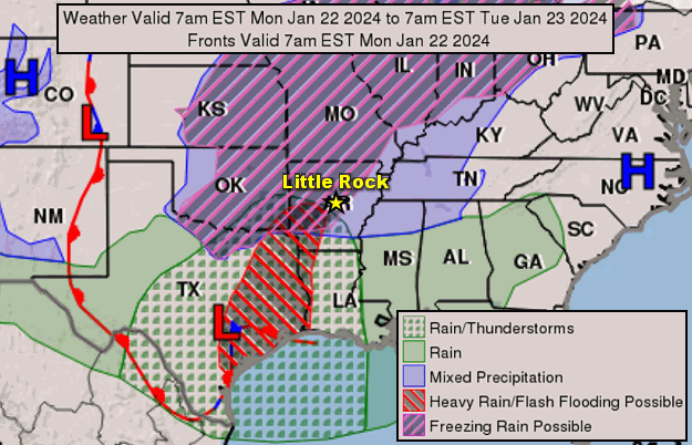 |
| In the picture: The forecast map showed Arctic high pressure ("H") along the mid-Atlantic Coast, and moving away from Arkansas on 01/22/2024. Even so, temperatures remained subfreezing early in the day as moisture increased from the southwest. This led to a period of freezing rain in the morning. As temperatures slowly warmed, much of the state had rain in the afternoon, with much more to come in the days to follow. |
|
| |
|
On the heels of a second blast of Arctic air in January (late on the 18th through the 21st), warmth and moisture tried to build into Arkansas from the southern Plains on the 22nd. This air mass flowed over a shallow layer of subfreezing conditions that lingered near the ground. When rain eventually developed, it turned to ice.
|
|
|
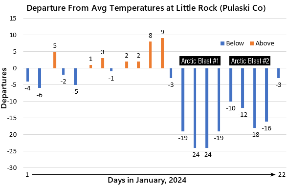
| In the picture: Temperatures were well below average at Little Rock (Pulaski County) from January 14-21, 2024. Two blasts of Arctic air were responsible, with this event at the end of blast number two. |
|
| |
|
Freezing rain began before dawn and continued through the morning in northern, western, and central sections of the state. This included the Ozark and Ouachita Mountains, and the Arkansas River Valley west of Little Rock (Pulaski County).
|
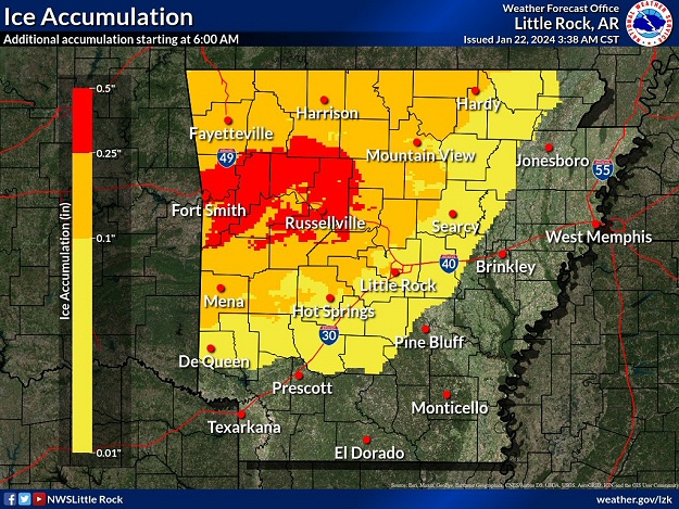 |
| In the picture: The forecast called for widespread ice accumulations from a tenth to more than a quarter inch (an ice storm) in much of northern, western, and central Arkansas on 01/22/2024. |
|
| |
|
Ice accruals mostly ranged from a little less than a tenth of an inch to a little over a quarter inch. One of the larger accruals reported was almost four tenths of an inch near Strickler (Washington County). Lavaca (Sebastian County) had 0.25 inch, with around two tenths of an inch at Harrison (Boone County) and Russellville (Pope County), and 0.14 inch at Hot Springs (Garland County). De Queen (Sevier County), Dierks (Howard County), and the North Little Rock Airport (Pulaski County) had 0.10 inch.
|
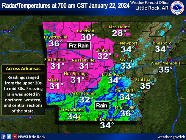 |
| In the picture: The WSR-88D (Doppler Weather Radar) showed precipitation over the southwest half of Arkansas at 700 am CST on 01/22/2024. Temperatures were below freezing in northern, western, and central sections of the state, and this is where freezing rain occurred. |
|
| |
|
Farther south/east, temperatures were barely warm enough to keep precipitation in the form of liquid (lower to mid 30s), and ice did not become an issue.
|
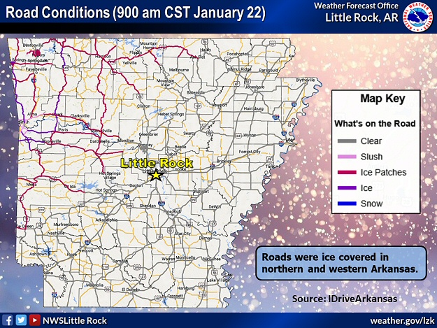 |
| In the picture: Roads were icy in parts of northern and western Arkansas at 900 am CST on 01/22/2024. The information is courtesy of IDriveArkansas. |
|
| |
|
By 900 am CST, many roads in the north/west were icy and dangerous. Fortunately, there was not enough ice to cause much in the way of power outages.
|
|
|
| In the video: Roads were icy and dangerous in the West Fork (Washington County) area early on 01/22/2024. The video is courtesy of Brian Emfinger via X (formally Twitter). |
|
| |
|
Numerous accidents occurred, with vehicles sliding off the pavement (unable to stop on the ice). By late morning/early afternoon, temperatures slowly climbed above 32 degrees, and road conditions improved. From there (the next five or so days), this turned into a heavy rain event.
|
 |
| Rain in Arkansas | Rain Across the Region |
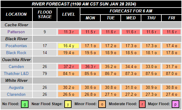
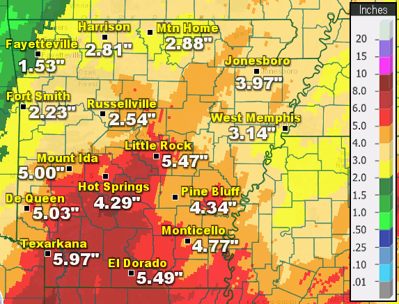
| In the pictures: Seven day rainfall ending at 600 am CST on 01/28/2024. Four to more than seven inches of rain dumped in portions of central and southern Arkansas. Along the Gulf Coast, more than ten inches of precipitation was measured in eastern Texas and southern Louisiana. |
|
| |
|
Four to more than seven inches of rain came down in central and southern Arkansas through 600 am CST on the 28th. Rainfall was generally steady, and rates were not high enough to cause much in the way of flash flooding. However, there was a lot of standing water, streams and creeks were on the rise, and a lot of ditches were full. Also, as Arctic air was replaced by a milder environment (temperatures in the 50s to lower 60s by the 24th), a lot of fog formed and visibilities dropped.
|
| Highest Rainfall Totals (Seven Day Period Ending at 600 am CST on 01/28/2024) |
| Location |
Amount |
| Magnolia (Columbia County) |
7.70" |
| Benton (Saline County) |
7.43" |
| Lewisville (Lafayette County) |
7.24" |
| Malvern (Hot Spring County) |
7.04" |
| Antoine (Pike County) |
6.72" |
| Murfreesboro (Pike County) |
6.44" |
|
On the evening of the 23rd, dense fog (and low visibility) may have been partly to blame for an accident involving a 27-year-old mother and her 5-year-old child. The vehicle they were in went off the road and overturned into a ditch filled with water near Trumann (Poinsett County). They were both killed.
|
|
|
| |
|
Minor to moderate flooding was noted along several tributaries including the Black, Cache, Little Missouri, Ouachita, and lower White Rivers. On the 27th, a swollen Ouachita River at Camden (Ouachita County) was at its highest level in six years, and inundated nearby roads. During the predawn hours, a motorist along one of these roads became stranded, and had to be rescued. A couple of days later, a levee was breached near Pitts (Poinsett County), and prompted Flood/Flash Flood Warnings for adjacent areas of Jackson and Poinsett Counties.
|
|
|