|
| Storm Reports |
| Are you interested in what happened during a recent event? Check out the report below. |
|
|
 |
Huge Hail/Damaging Wind/Isolated Tornadoes on June 25-26, 2023 |
 |
| |
 |
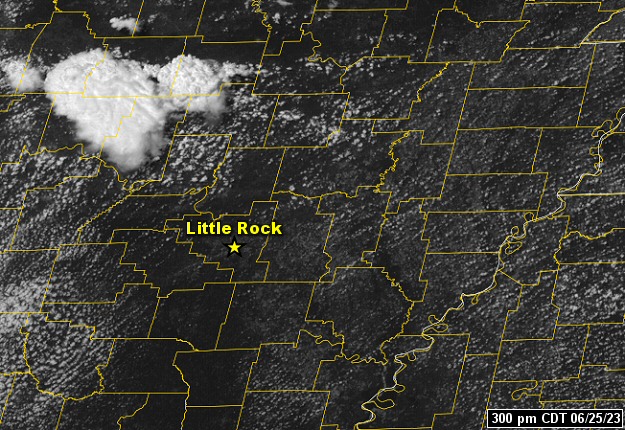
| In the picture: A storm system ("L") and west/northwest winds aloft moved around the periphery of high pressure ("H") and drove a cold front into a very unstable environment from the Ohio Valley to Arkansas on 06/25/2023. This is where severe storms were most likely. |
|
| |
|
A very busy June continued heading into the last week, but not before it got hot. Arkansas was on the fringe of high pressure to the southwest, and record heat in Texas. Del Rio, TX and San Angelo, TX had all-time record high temperatures of 115 degrees and 114 degrees respectively on the 21st. At the latter site, the same reading was reached the day before. We were getting a taste of these oppressive conditions on the 25th, with thermometers showing mid to upper 90s at most locations. As this was happening, a storm system and associated cold front moved around the periphery of the high, and reached the state during the afternoon and evening. It was about to get interesting.
|
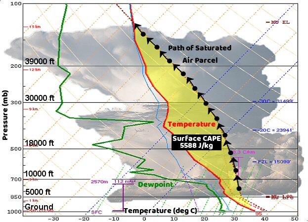 |
| Sounding at 300 pm CDT (06/25) | Heat Index Values at 400 pm CDT (06/25) |
| In the pictures: The sounding (temperature and dewpoint profile with height) at the North Little Rock Airport (Pulaski County) revealed a very unstable atmosphere at 300 pm CDT on 06/25/2023. Saturated air parcels were much warmer than the environmental temperature (arrows to the right of the red line), leading to extreme values of CAPE (Convective Available Potential Energy/a measure of instability). CAPE is directly related to updraft strength, and the parcels ascended rapidly to make clouds/storms. Heat index values values at 400 pm CDT ranged from 105 to 115 degrees across central and southern Arkansas. |
|
| |
|
The atmosphere was plenty unstable (well above normal temperatures/plenty of humidity) to support thunderstorm development as the front arrived. Afternoon heat indices peaked between 105 and 115 degrees across much of the region (except the Ozark and Ouachita Mountains). Data acquired with a balloon at 300 pm CDT indicated CAPE (Convective Available Potential Energy/a measure of instability) values close to 6,000 Joules/kilogram! This meant that storm updrafts would be powerful, and easily able to suspend hailstones aloft (allowing them to grow). Once these storms collapsed, a rush of cooler air would likely send other storms (on the leading edge of the outflow) quickly downstream to produce destructive winds.
|
|
|
| |
|
It was all put into motion at 225 pm CDT. This is when the first Severe Thunderstorm Warning was issued for Franklin and Madison Counties (northwest Arkansas). There were several reports of huge hail across the north, and then a transition to wind began as storms headed into central/eastern Arkansas by 500 pm CDT.
|
|
|
| In the picture: Tennis ball size hail was collected near Salus (Newton/Johnson Counties) during the afternoon of 06/25/2023. The photo is courtesy of Stevie French through Zachary Hall via Twitter. |
|
| |
|
Grapefruit size hail occurred at Thola (Searcy County), with hail slightly larger than baseballs a few miles northwest of Gold Hill (Pope County), Landis (Searcy County), Mountain View (Stone County), and Timbo (Stone County). Salus (Johnson/Newton Counties) got tennis ball size hail.
|
| Baseball Size Hail or Larger (June 25, 2023) |
| Location |
Hail Size (Inches) |
| Thola (Searcy County) |
4.50 |
| Landis (Searcy County) |
3.00 |
| Mountain View (Stone County) |
3.00 |
| Timbo (Stone County) |
3.00 |
| 3 WNW Gold Hill (Pope County) |
3.00 |
| Note: Miles and directions from locations are shown, such as "3 WNW" (three miles west-northwest). |
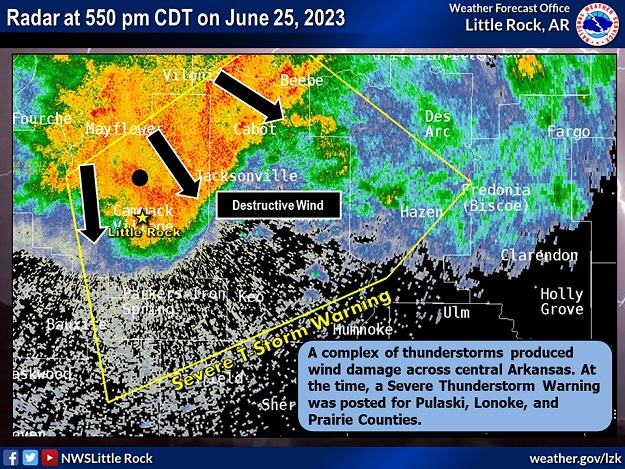 |
| In the picture: A complex of thunderstorms produced wind damage across central Arkansas during the late afternoon of 06/25/2023. At the time (550 pm CDT), a Severe Thunderstorm Warning was posted for Pulaski, Lonoke, and Prairie Counties. |
|
| |
|
While the hail was impressive, so was the wind. Gusts from 75 to 80 mph were measured near McCreanor and Tomberlin (both in Lonoke County). A 69 mph gust was recorded at Little Rock National Airport (Pulaski County), and Swifton (Jackson County) had a 68 mph gust. The wind gusted to 60 mph at DeWitt (Arkansas County), and 59 mph at Jonesboro Municipal Airport (Craighead County).
|
|
|
| In the picture: A tree fell through a house in Conway (Faulkner County) during the afternoon of 06/25/2023. The photo is courtesy of Brandon Miller via Twitter. |
|
| |
|
Trees, power lines, and power poles were all over the place at Conway (Faulkner County). Some of the trees were on homes and vehicles. A woman was pinned under a tree in her house and was injured. According to one media source, a local official called it the worst storm damage in decades. Trees were also toppled at Carlisle (Lonoke County). A tree landed on a mobile home, and killed two people. Another resident was injured.
|
|
|
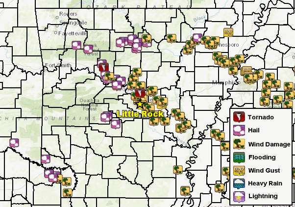
| In the picture: There were numerous reports of severe weather across Arkansas on June 25-26, 2023. |
|
| |
|
Trees and/or power poles were downed or snapped in many places including Allison (Stone County), Bono (Craighead County), Cave City (Sharp County), Dermott (Chicot County), DeWitt (Arkansas County), Eudora (Chicot County), Humphrey (Arkansas/Jefferson Counties), Keo (Lonoke County), the Little Rock (Pulaski County) area, Lonoke (Lonoke County), Morrilton (Conway County), Terrell (Crittenden County), Tuckerman (Jackson County), Ulm (Prairie County), Vilonia (Faulkner County), and Wilson (Mississippi County). A whopping 150,000 utility customers lost power!
There was major structural damage noted at a church in England (Lonoke County). Metal farm buildings were roughed up near Calvin (Lawrence County).
Finally, there was a weak tornado (rated EF1) identified two to three miles east-northeast of Dover (Pope County). Trees were uprooted in a converging pattern, which is a sign of a tornado. Another tornado (rated EFU, where "U" is unknown due to a lack of surveyable evidence) touched down briefly just southwest of Cato (Pulaski County).
|
|
|
| In the picture: This is a Top 3 most active June in Arkansas as far as all severe weather reports, severe wind reports, and severe hail reports. |
|
| |
|
Through the 25th, this was the second most active June on record as far as the number of severe weather reports (wind and hail). 2009 took the top spot. Reports of large hail topped the list by far, with close to forty instances of very large hail (two inches in diameter or larger). 2009 was in second place with only seven cases of very large hail.
Outside of Arkansas, a half dozen tornadoes tore through southern Indiana and central Kentucky on the 25th. Hail reached tennis ball to softball size, and damaging straight-line wind gusts peaked over 100 mph. One of the stronger tornadoes (rated EF2) caused a home to collapse just south of Windom, IN. This resulted in a fatality and an injury.
|
|
|
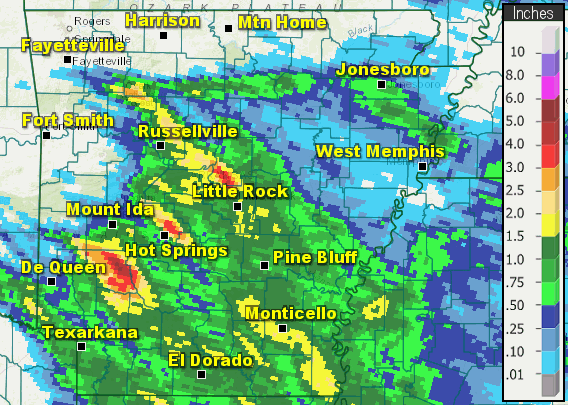
| In the picture: Twenty four hour rainfall through 700 am CDT on 06/26/2023. |
|
| |
|
Back at home, far northern sections of the state missed out on significant rainfall during this event. This is where abnormally dry conditions existed as of the 20th, as well as a moderate drought in the northeast. Farther south, some sites picked up more than two inches of precipitation in the twenty four hour period ending at 700 am CDT on the 26th. Antoine (Pike County) received 3.31 inches of rain, with 3.10 inches at Murfreesboro (Pike County), 2.68 inches at Conway (Faulkner County), 2.45 inches at Marche (Pulaski County), 2.32 inches at Morrilton (Conway County), and 2.24 inches at Malvern (Hot Spring County).
|
|
|