| |
Temperatures |
Precipitation |
| Site |
Max |
Min |
Avg |
Norm |
Dep |
Hi |
Lo |
Sum |
Norm |
Dep |
| Fayetteville (NW AR) |
88.2 |
63.0 |
75.6 |
73.6 |
+2.0 |
98 |
56 |
4.63 |
4.31 |
+0.32 |
| Harrison (NC AR) |
86.2 |
63.0 |
74.6 |
74.4 |
+0.2 |
99 |
55 |
4.39 |
3.85 |
+0.54 |
| Jonesboro (NE AR) |
88.7 |
68.0 |
78.4 |
79.0 |
-0.6 |
98 |
59 |
4.32 |
3.05 |
+1.27 |
| Fort Smith (WC AR) |
91.5 |
69.3 |
80.4 |
78.8 |
+1.6 |
102 |
64 |
2.63 |
4.56 |
-1.93 |
| Little Rock (C AR) |
91.6 |
70.3 |
81.0 |
78.1 |
+2.9 |
100 |
66 |
4.49 |
3.55 |
+0.94 |
| Texarkana (SW AR) |
94.1 |
72.3 |
83.2 |
78.9 |
+4.3 |
99 |
67 |
6.55 |
3.92 |
+2.63 |
| El Dorado (SC AR) |
90.8 |
68.0 |
79.4 |
79.3 |
+0.1 |
96 |
62 |
5.33 |
3.88 |
+1.45 |
| Pine Bluff (SE AR) |
91.0 |
70.0 |
80.5 |
79.1 |
+1.4 |
98 |
66 |
3.53 |
3.27 |
+0.26 |
Temperatures were generally above to well above average (by more than four degrees in some cases). Precipitation was above average across much of the state, with some locations seeing amounts more than 2 inches above average.
| |
| There were no temperature records tied or broken in June. |
| |
| Site |
Record High (Date of Occurrence) |
| |
|
 |
| In the picture: A NWS Storm Prediction Center map of storm reports received during the month of June. |
| |
Hot and dry conditions in place across the state in late May persisted through at least the first week of June as little to no rain fell in many places during that timeframe and temperatures climbed into the 90s in most locations. After the quiet first week of June things rapidly escalated across the state and much of the country. June 2023 was one for the record books, with tens of millions of dollars worth of damage caused by severe storms across Arkansas.
While overall severe weather reports in May were lower than average, this June was the most active since June 2011 (in the US). Locally, severe weather reports in June across Arkansas were the highest since at least the year 2000. There were more severe weather reports in June than the months from Jan-May combined. When counting only tornadoes, June 2023 had the second highest count on record (6) falling short of the record (8) set in both June of 1989 and 1998.
In addition to the active severe weather during the month, dangerous heat became a concern near the end of the month with a few sites reaching the century mark from June 28-30. Abundant moisture remained in place as well, which made temperature in the 90s to around 100 feel more like 105-120 at times.
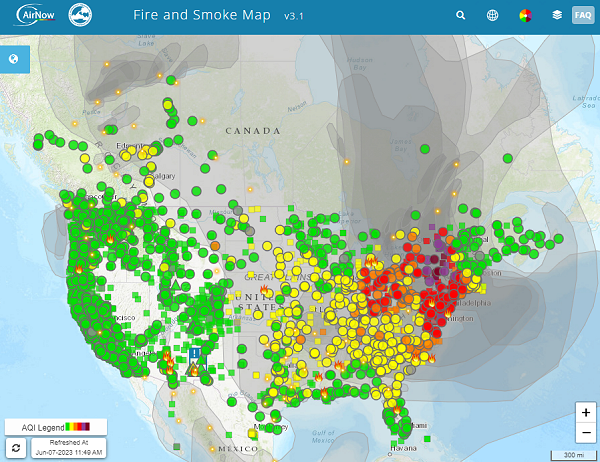 |
| In the picture: Large western Canada wildfires continued to produce significant amounts of smoke that moved into northern, central and eastern parts of the US. This led to poor air quality as noted in this image on June 7. |
| |
Other than the widespread severe weather observed across the state in June and the late month dangerous heat, parts of the US had to contend with poor air quality at times. This reduction in air quality was due to significant amounts of smoke caused by very large wildfires across western Canada. EPA air quality sensors recorded some of the world's worst air quality at times across parts of the United States.
|
|
| In the picture: A strong thunderstorm was observed from the NWS office in North Little Rock as well as by the NWS radar. |
| |
 |
| In the picture: Swaths of large hail revealed the paths of severe storms (mostly from northwest to southeast) on 06/14/2023. Hail was up to two inches in diameter during the morning, and up to softball size (four inches in diameter) in the afternoon/evening. |
| |
A persistent pattern that provided dangerous heat to parts of Texas and the southwest US allowed for storm systems to repeatedly track across the middle and southern parts of the country. With a strong ridge of high pressure to the southwest, storm systems would ride southeastward along the northern periphery of the ridge, impacting areas along the way. This led to numerous severe weather events that caused widespread wind damage, very large hail and even a few tornadoes.
Hail to the size of baseballs (or larger) occurred across the state on June 11,13,14,16 and 25. 6 tornadoes occurred across the state. These took place on June 18 (4) and June 25 (2).
|
|
| In the picture: A look at the severe weather setup in place for June 25. |
| |
Widespread thunderstorms moved across the state on the 25th. Hail larger than baseballs fell, wind damage occurred in numerous locations and two weak tornadoes developed in Perry and Pulaski Counties. Damaging winds associated with a line of thunderstorms caused 2 injuries as well as 2 fatalities. These were all caused by trees falling on homes.
| Temperature and Precipitation Trends |
| |
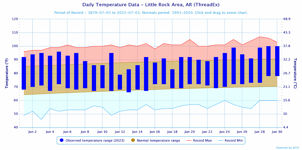 |
| In the picture: Temperatures at Little Rock (Pulaski County). Click to enlarge. |
|
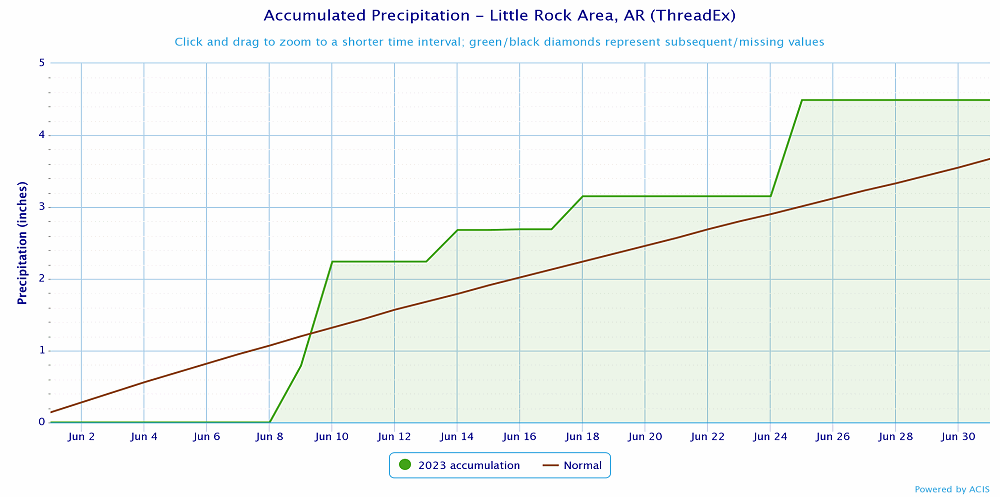 |
| In the picture: Precipitation at Little Rock (Pulaski County). Click to enlarge. |
|
 |
| In the picture: Precipitation across Arkansas. |
|
|


