 |
| Storm Reports |
| Are you interested in what happened during a recent event? Check out the report below. |
|
|
 |
Severe Storms on March 14-15, 2025 |
 |
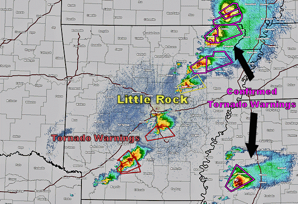 |
| In the picture: Radar view of tornado producing storms from the late evening hours of March 14, 2025. |
|
| |
| A powerful storm system moved from the Southern Plains toward the Great Lakes from Friday, March 14th to Saturday, March 15th. On the 14th, a dry line and cold front at the surface moved east into the state. A sufficient amount of moisture was in place across the state and surrounding areas along with strong instability and available wind shear. Storms began to develop across far southern Missouri and north-central Arkansas during the evening hours of March 14th and continued through the late evening and overnight hours, eventually expanding south and east across much of the state. |
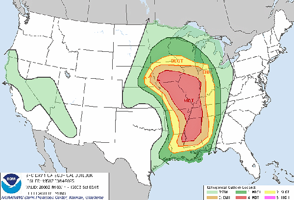 |
| In the picture: The NWS Storm Prediction Center issued Day 1 convective outlook included enhanced and moderate risk areas for severe weather across parts of Arkansas and locations to the north and south of the state. |
|
| |
|
The NWS Storm Prediction Center had been issuing severe weather outlooks well in advance of this severe weather event. The first outlook was issued on March 9th, which highlighted a slight risk of severe weather for March 14th from southeast Iowa to southern Louisiana. On March 10th, an enhanced risk of severe weather was outlined across all but western and southern Arkansas as well as adjacent portions of Missouri, Tennessee and Mississippi. As the event drew near, a moderate risk area was eventually introduced which encompassed much of the Mid and Lower Mississippi River Valley, including northeast Arkansas.
|
|
|
| In the post: A radar confirmed tornado was observed near Melbourne (Izard County) moving northeast toward Ash Flat (Sharp County). |
|
| |
|
As the storms developed during the evening of March 14th, they encountered a favorable environment which allowed them to become powerful supercells. They quickly began to rotate and many of these storms produced severe weather, including some hail as well as several tornadoes. The best overlap of favorable ingredients for tornadoes to occur existed across the northeast third of the state. Storms in these areas produced several tornadoes of which many were strong (EF2 or higher rating).
|
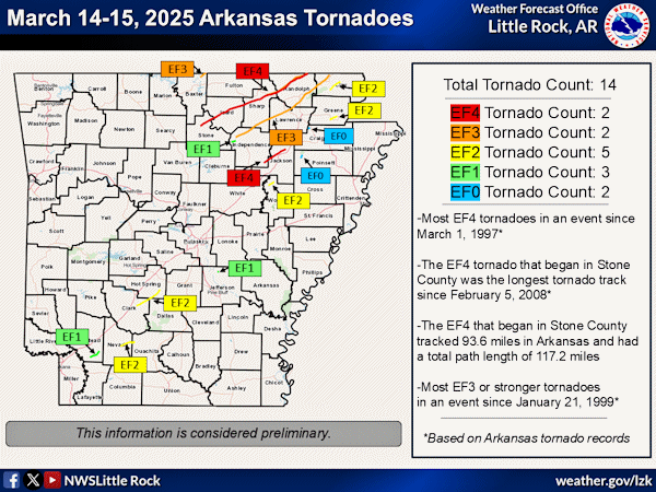 |
| In the picture: Preliminary surveyed tornado tracks across Arkansas from March 14-15, 2025. |
|
| |
|
Given the volatile environment, some tornadoes remained on the ground for a long time. Most tornadoes that occur across Arkansas and surrounding areas are usually weak and only persist for a short while. This was not the case with this event and some of the tornadoes ended up having total path lengths of more than 10 miles with one tornado ended up being on the ground for over 100 miles. This is exceptionally rare and only occurs during some of the most devastating tornado events noted over the years.
|
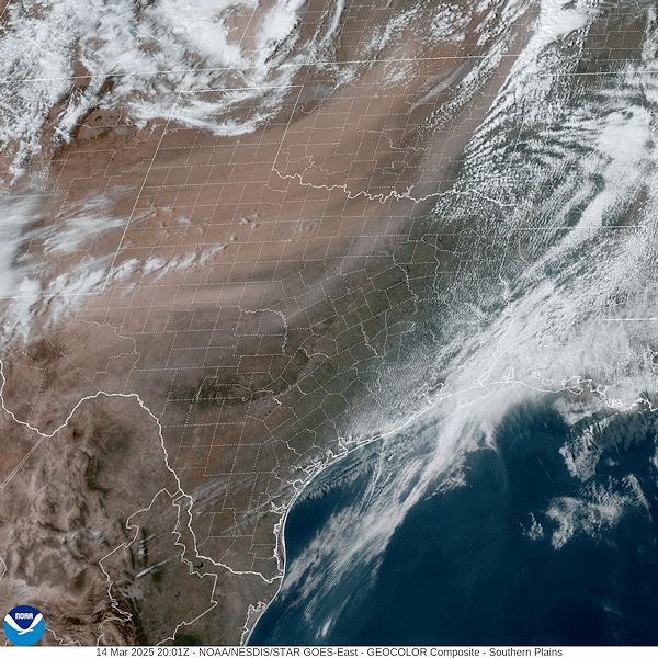 |
| In the picture: Visible satellite imagery from the afternoon of March 14, 2025 shows dust being lifted northeast across Texas, Oklahoma and Kansas. |
|
| |
|
One indication of how strong the upper level and surface low pressure systems were was the amount of dust that was transported into the state from the southwest US. Dust was readily transported from west Texas and southeast New Mexico across portions of Oklahoma, Arkansas and Missouri. Non-thunderstorm wind gusts from the Texas panhandle into Oklahoma were in the 60 to 80 mph range with some locally higher gusts observed as well. The dust led to hazy conditions across Arkansas from March 14-15 with many locations that received precipitation reporting muddy rainfall and dirty vehicles after things dried out.
|
|
|

