Are you interested in what happened during a recent event? Check out the report below.
Severe Storms/Flooding Rain on March 14-15, 2024
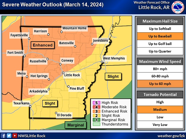
In the picture: There was an enhanced risk of severe weather across the northwest half of Arkansas during the afternoon and evening of 03/14/2024. This is where very large hail (golf ball size or bigger), wind damage, and isolated tornadoes were most likely. The forecast is courtesy of the Storm Prediction Center in Norman, OK.
Heading into mid-March, there was not much severe weather in Arkansas to start 2024. There was only one confirmed tornado (on February 9th) between Sardis and East End (both in Saline County). Even so, an active weather pattern was setting up on March 14th, and additional tornadoes were possible.
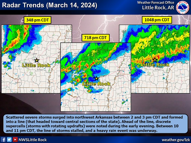
In the pictures: Scattered severe storms in northwest Arkansas formed into a line during the afternoon of 03/14/2024. Ahead of the line, discrete supercells (storms with rotating updrafts) were noted in the early evening from west central into central sections of the state. This is where a combination of instability and shear were the most supportive of tornadoes. As the evening progressed, the line of storms stalled across the central counties, and a heavy rain event was underway.
A cold front plowed into a very unstable environment during the early afternoon. Thunderstorms mushroomed in the northwest half of the state, with powerful updrafts driving moisture well aloft to make ice/very large hail. While the wind turned with height to create rotation in developing storms, it was not as impressive as the instability. It appeared any tornadoes would be isolated.
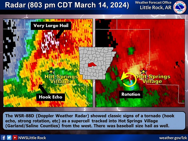
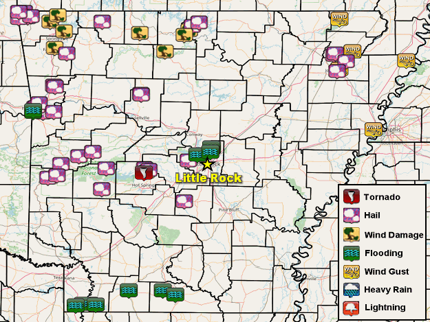
In the picture: The WSR-88D (Doppler Weather Radar) showed classic signs of a tornado (hook echo, strong rotation, etc) as a supercell tracked into Hot Springs Village (Garland/Saline Counties) from the west around 800 pm CDT on 03/14/2024. There was baseball size hail as well.
The storms that caused the most concern popped up in the evening from west central into central Arkansas. These discrete cells mostly rotated aloft (above 8,000 feet), with less spin toward the ground. However, one storm managed to turn more than the rest, and a tornado was spawned at Hot Springs Village (Garland/Saline Counties).
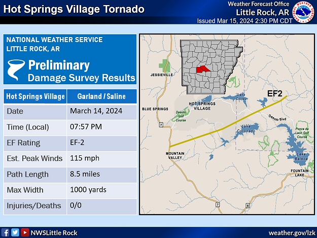
In the picture: A tornado (rated EF2) tracked 8 to 9 miles through Hot Springs Village (Garland/Saline Counties) during the evening of 03/14/2024.
The chaos started close to Highway 7 just north of the Mountain Valley (Garland County) community. Numerous trees were downed or snapped along the path (8 to 9 miles) of the tornado (rated EF2). Many homes were damaged mainly by falling trees. Baseball size hail was also reported. The local water treatment plant lost power, and relied on generators. Leaks were also detected, and the system became overwhelmed leading to water shortages.
In the video: There was a lot of damage/chaos following a tornado (rated EF2) in Hot Springs Village (Garland/Saline Counties) during the evening of 03/14/2024. The video is courtesy of Brian Emfinger via YouTube.
This was the only tornado counted during the event, but there was a close call worth mentioning. As the parent storm headed to the east, video captured a funnel cloud illuminated by lightning in west Little Rock (Pulaski County).
In the picture: Severe weather and flash flood reports on March 14-15, 2024.
Elsewhere, there was softball size hail west of Sulphur Springs (Benton County), and tea cup size hail at Gravelly (Yell County). Tennis ball to baseball size stones pelted Gravette and Maysville (both in Benton County), with golf balls near Prattsville (Grant County) and at Y City (Scott County). Thunderstorm wind gusts estimated around 65 mph damaged a boat dock on Beaver Lake southeast of Monte Ne (Benton County). Trees were toppled at Harrison (Boone County).
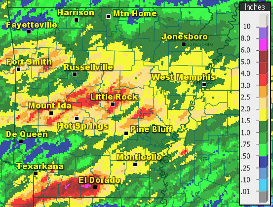
In the picture: Twenty four hour rainfall through 700 am CDT on 03/15/2024.
Late on the 14th/early on the 15th, this turned into a heavy rain event across the central and southern counties. Some locations received more than four inches of precipitation. Twenty four hour totals as of 700 am CDT on the 15th included 6.10 inches at El Dorado (Union County), 5.35 inches at Cabot (Lonoke County), 4.01 inches at Little Rock (Pulaski County), 3.91 inches at Thatcher Lock and Dam (Union County), 3.50 inches at Hot Springs National Park (Garland County), and 3.45 inches at Moro Bay State Park (Bradley County).
FLOODINGðŸŒŠâš¡ï¸ The Maumelle Fire Department is using a BOAT to rescue residents at the Windsor Place Townhomes. Thank you to our first responders for alway answering the call. #ARWX@KARK4News@FOX16Newspic.twitter.com/6oTbJXR3tJ
In the video: More than four inches of rain dumped in Maumelle (Pulaski County) during the evening of 03/14/2024, and this led to flooding in places. Vehicles were stalled or stranded in high water, and rescues by boat became necessary. The video is courtesy of Gary Burton JR via X (formally Twitter).
The rain came down so fast in Maumelle (Pulaski County) that high water stranded vehicles and created a lake near some townhomes. People had to be rescued by boat. Highway 160 between Bradley (Lafayette County) and Doddridge (Miller County) was flooded and closed. Roads were under water and/or washed out from El Dorado (Union County) to Lisbon (Union County) and Magnolia (Lafayette County). Cars were stalled, and motorists needed assistance.