 |
| Storm Reports |
| Are you interested in what happened during a recent event? Check out the report below. |
|
|
 |
Isolated Severe Storms on January 5, 2025 |
 |
| |
|
|
| |
|
The year (2025) got off to a fast start, with an active pattern in play by the 4th. At that time, snow and ice were spreading through the central Plains toward the mid-Mississippi Valley. In Arkansas, we were focused more on severe weather.
|
 |
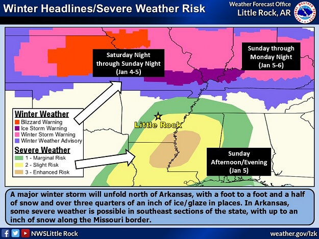
| Winter Headlines/Risk of Severe Weather (01/04) | Probabilistic Scenario (01/02) |
| In the pictures: By the late afternoon of 01/04/2025, winter headlines (including Blizzard Warnings) were posted to the north of Arkansas, with a risk of severe thunderstorms (the next day) in southeast sections of the state. The headlines fit the probabilistic scenario of snow, ice, and severe weather three days prior to the event. |
|
| |
|
Scattered severe thunderstorms were in the forecast in southeast sections of the state during the afternoon of the 5th. This was ahead of a southern Plains storm system surrounded by subfreezing air to the north and very mild (springlike) conditions to the south.
|
 |
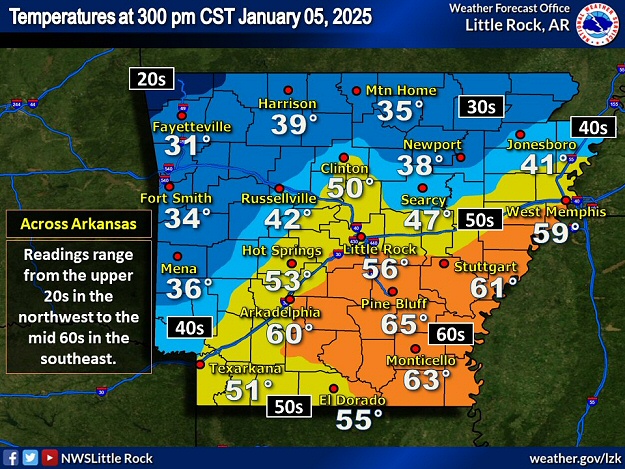
| In the picture: At 300 pm CST on 01/05/2025, temperatures varied by more than thirty degrees across Arkansas, and ranged from the upper 20s in the northwest to the mid 60s in the southeast. |
|
| |
|
In the southeast, temperatures climbed into the 60s on the 5th, and there was enough warmth and moisture (instability/fuel) to support thunderstorm development. There was a tremendous amount of wind energy and a lot of turning with height. This caused thunderstorms to rotate and eventually spawn isolated tornadoes.
|
|
|
| In the video: A weak tornado (rated EF1) tracked through areas just north and west of Garrett Bridge (Lincoln County) during the afternoon of 01/05/2025. The video is courtesy of Blake Morgan via X (formally Twitter). |
|
| |
|
A weak tornado was witnessed just north and west of Garrett Bridge (Lincoln County) around 205 pm CST. The tornado roughed up two chicken houses and damaged the roofs on a couple of homes. This was the first tornado of the year in Arkansas and was given an EF1 rating. Elsewhere, thunderstorm gusts downed trees near Perrytown (Hempstead County).
|
|
|
| In the picture: Heavy snow accumulated north of Arkansas in the seventy two hour period ending at 600 am CST on 01/07/2025. |
|
| |
|
After the storm system exited to the east, cold air poured into the region. West to northwest winds gusted to 30 to 40 mph. Lingering moisture resulting a brief period of light snow/flurries toward the Missouri border. There was enough snow (mostly a dusting) to cover roads in the northwest (Ozark Mountains).
Snow was a much bigger issue in a swath from Kansas into northern/central Missouri and all the way to the central Appalachians, northern Virginia, Maryland, and Delaware. Eight to twelve inches of powder covered a lot of real estate, with foot to foot-and-a-half accumulations in places. Just south of the snow area, a stripe of freezing rain/ice was crippling (half to three quarter inch accruals) in some cases (downing trees/power lines/causing widespread power outages).
|
|
|