National Weather Service United States Department of Commerce
Monthly Storm Reports and Storm Data
Storm Reports
Are you interested in what happened during a recent event? Check out the report below.
 
September, 2023 Monthly Summary
 
Monthly Statistics
 
  Temperatures Precipitation
Site Max Min Avg Norm Dep Hi Lo Sum Norm Dep
Fayetteville (NW AR) 86.7 59.2 73.0 69.0 +4.0 97 50 5.45 4.26 +1.19
Harrison (NC AR) 83.5 59.6 71.6 69.9 +1.7 93 50 5.65 4.06 +1.59
Jonesboro (NE AR) 88.4 63.6 76.0 73.2 +2.8 96 53 1.94 3.30 -1.36
Fort Smith (WC AR) 90.1 66.7 78.4 74.8 +3.6 102 60 3.40 4.04 -0.64
Little Rock (C AR) 91.1 67.0 79.1 74.0 +5.1 102 59 0.46 3.01 -2.55
Texarkana (SW AR) 88.9 66.8 77.8 75.4 +2.4 101 60 3.54 3.60 -0.06
El Dorado (SC AR) 88.1 65.1 76.6 75.8 +0.8 97 57 4.44 3.23 +1.21
Pine Bluff (SE AR) 92.4 65.9 79.2 74.7 +4.5 104 56 0.49 3.09 -2.60


Temperatures across the state during September were well above average while precipitation was well below average. 


Record Temperatures
 
Temperature records broken in September. Check out the records below.
Site Record High (Date of Occurrence)
Jacksonville/LR AFB 92T (9/26)
Batesville 94 (9/29), 95T (9/30)
Stuttgart 93T (9/29)
North Little Rock 92 (9/26)
 
 
Quick Event Summary
 

While there were a few periods of active weather, cool temperatures and heavy rainfall across parts of the state during the month, September will be remembered for being hot and dry with worsening drought conditions. 


A map of Arkansas that shows burn bans and wildfire danger.
In the picture: Maps of Arkansas that show burn bans and wildfire danger as of September 1st. 
 

Storms were noted at the beginning of the month with cool temperatures briefly seen before warming back up through the 6th. Widespread storms were noted on Labor Day with some areas receiving 1-3 inches of rain, many areas continued to miss out on beneficial rainfall. 

A front moved through the state on September 6th after highs hit 100 or more in some areas. A few severe thunderstorms developed across central into southern Arkansas causing wind damage. The most notable severe weather occurred as a thunderstorm rapidly developed and collapsed over West Little Rock and produced a microburst that unleashed 70-80 mph winds along areas that were impacted by the March 31st tornado near I-430 and Rodney Parham. Power outages were in excess of 16,000 with numerous homes and businesses damaged as well as hundreds of downed trees.

Hot temperatures persisted across western Arkansas on the 7th when a few sites hit 100 again. A few storms developed across southern AR and moved into northern LA. Camden recorded a wind gust of 53 mph. More storms developed overnight into the early morning hours on the 8th across western Arkansas, moving S-SE. These storms brought locally heavy rain, a lot of lightning and some hail. The main story was damaging wind across portions of Crawford County and again from southern Montgomery County across Pike County. The most widespread damage was in Pike County where numerous state highways were blocked by downed power lines and trees. The rain and clouds kept temperatures cool across much of the state.


In the picture: The morning of September 15th was quite cool across the state with locations across northern and western Arkansas seeing lows in the upper 40s.
 

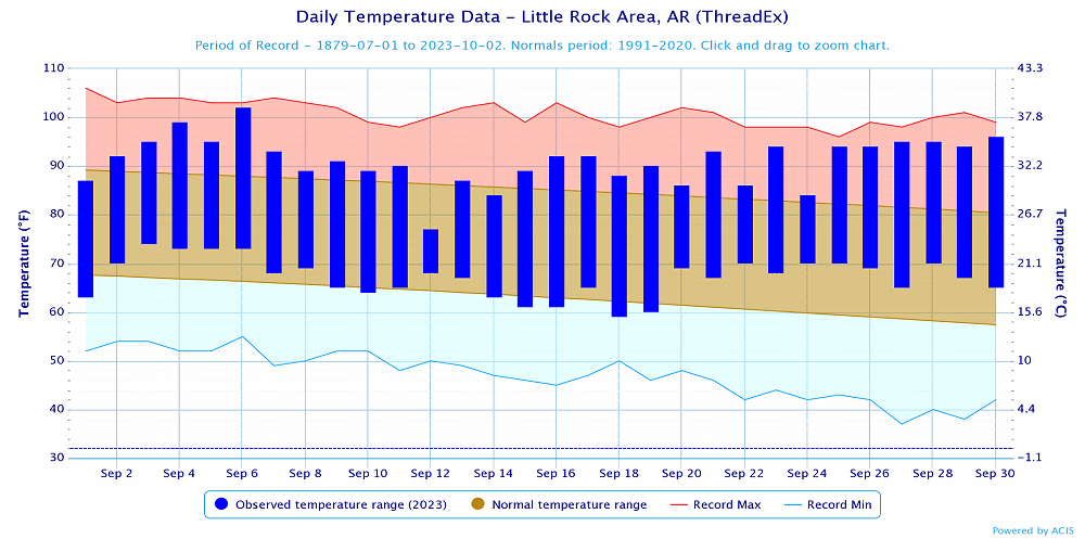
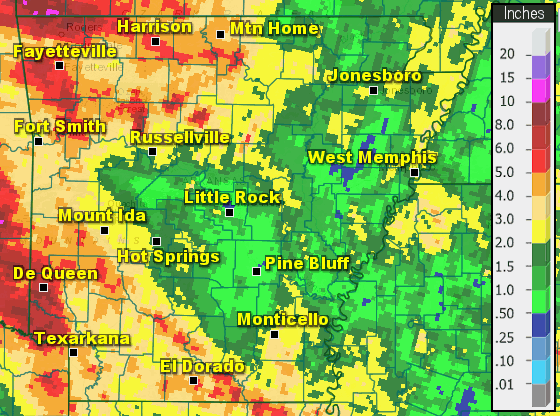
Warm temperatures but below normal were observed through the 12th when a cold front moved across the state and brought some rain with it. Most locations picked up less than 0.25” but a few spots picked up locally higher amounts. This brought cooler temperatures to the area. Some rain persisted across southern AR from Sep 13-14. Dry air was in place through the 18th which helped overnight lows become fairly cool with daytime highs climbing to near to above average. 

A weak storm system moved across the region from Sep 19-20 with rain observed across much of northern and western AR on the 20th. Some areas experienced heavy rain, but plenty of locations across the state missed out entirely.

A stronger storm system moved across the Central/Southern Plains on Saturday, Sep 23rd which caused widespread strong to severe storms across eastern OK, KS and southern MO. A few strong storms moved across western AR, but no reports of severe weather were received. Locally heavy rain occurred across the NW, but beneficial rain spread southeast across much of the state during the morning hours of the 24th.  

Beyond the 24th, hot and dry conditions were seen nearly statewide. 
 

A map of Arkansas that shows drought conditions as of September 28.
In the picture: A map of Arkansas that shows drought conditions as of September 28.


Link of Interest
Dry across Central/Eastern Arkansas in September
 
Temperature and Precipitation Trends
 
Temperatures at Little Rock (Pulaski County).
In the picture: Temperatures at Little Rock (Pulaski County). Click to enlarge.


Precipitation at Little Rock (Pulaski County).
In the picture: Precipitation at Little Rock (Pulaski County). Click to enlarge.


Precipitation across Arkansas.
In the picture: Precipitation across Arkansas.


Link of Interest
Detailed Monthly Statistics