 |
| About This Page |
| Arkansas has had its share of historic events, many of which will be in our memories for years to come. |
|
|
 |
Heavy Rain/Deadly Flash Flooding on June 10-11, 2010 |
 |
| |
|
|
While high pressure began building over the southeast United States on June 10th, a storm system aloft moved slowly around the high from northeast Texas into southwest Arkansas. |
| In the pictures: A storm system ("LOW") tracked into Arkansas from the southwest by 06/10/2010. The system moved around a building ridge of high pressure ("HIGH") in the southeast United States. |
| More About the Storm |
| Before the storm system arrived, it was responsible for significant flash flooding in Texas. On June 9th, the system dumped more than 10 inches of rain about 20 miles northeast of San Antonio (south central Texas) in Comal and Guadalupe Counties. Several people were rescued from rooftops and evacuations were ordered. On the 10th, similar precipitation amounts closed roads in Tyler (northeast Texas), and there were numerous rescues from flooded homes in neighboring towns. Ironically, the rain hit during the early morning hours in both cases as it did in Arkansas (on the 11th). |
| The system brought two rounds of showers and thunderstorms from southwest into central sections of the state during the afternoon and evening hours. |
|
| In the pictures: The satellite showed one area of clouds and precipitation from southwest into central Arkansas during the afternoon of 06/10/2010. This was followed closely by an MCS (Mesoscale Convective System...or large cluster of showers and thunderstorms) by evening. |
 |
| In the picture: Heavy rain occurred from northeast Texas into western Arkansas in the twenty four hour period ending at 700 am CDT on 06/11/2010. |
|
| |
|
By the early morning hours of the 11th, rain was widespread from Texarkana (Miller County) to Little Rock (Pulaski County). One to three inch amounts were common, with locally over four inches.
|
 |
Twenty four hour rainfall totals through 700 am CDT on the 11th included 6.83 inches at Mount Ida (Montgomery County), 6.78 inches at Hopper (Montgomery County) and 6.55 inches at Glenwood (Pike County). |
| In the picture: Twenty four hour precipitation through 700 am CDT on 06/11/2010. |
| There was at least half a foot of rain at the Albert Pike Recreation Area (Montgomery County). With this much liquid, a serious flash flood event unfolded. |
|
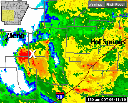
| In the pictures: The WSR-88D (Doppler Weather Radar) showed storms continually developing to the southeast of Mena (Polk County) and moving over the Albert Pike Recreation Area (Montgomery County)...or "X"... during the early morning hours of 06/11/2010. |
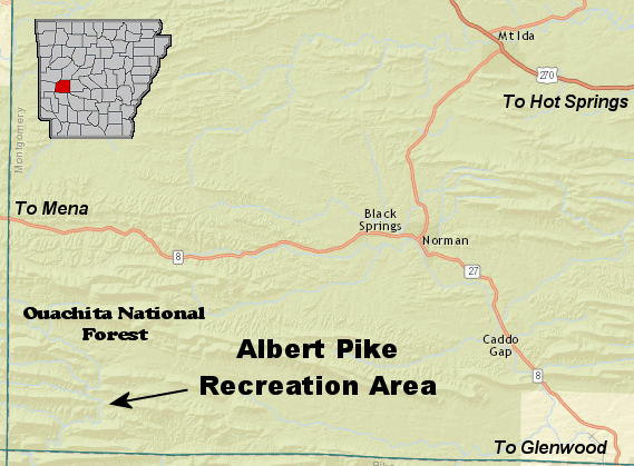 |
| In the picture: Flash flooding devastated the Albert Pike Recreation Area (Montgomery County) early on 06/11/2010. There are several small creeks and streams in and around the campground, including the Little Missouri River. These tributaries rose rapidly during the event (due to at least six inches of rain in just a few hours). |
|
| |
| As many as 200 to 300 people campers awoke to rapidly rising water. Tragically, there were 20 fatalities reported at this location. |
| The Little Missouri River, which runs through the area, climbed almost 20 feet in just a few hours at the nearby town of Langley (Pike County). |
| Why Was This Event So Deadly? |
| (1) Rainfall Rates: Two to three inches of rain fell per hour for several hours. |
| (2) Terrain: Water flowed rapidly down hillsides, collected in small streams and creeks, and was funneled into the Little Missouri River. |
| (3) Type of Tributary: Most rivers rise and fall slowly over a period of days. The Little Missouri River is more flashy, and goes up and down in hours. |
| (4) Time of Day: This event occurred in the middle of the night when people were asleep. |
| (5) Location: The remoteness of the area made it difficult to relay information. High water cut off access into and out of the area, making escape/rescue efforts difficult to impossible. |
| The river crested just over 23 feet, which is the highest level since records began in 1988 (according to the USGS...or United States Geological Survey). This shattered the previous record by 10 feet! |
| Little Missouri River at Langley (Pike County) on 06/11/2010 |
| Time |
Stage (ft) |
| 200 am CDT |
3.81 |
| 230 am CDT |
5.83 |
| 300 am CDT |
9.87 |
| 330 am CDT |
13.91 |
| 400 am CDT |
17.70 |
| 430 am CDT |
20.57 |
| 500 am CDT |
22.30 |
| 530 am CDT |
23.39 |
| 600 am CDT |
22.40 |
| 630 am CDT |
19.41 |
|
In a media interview, a woman living in the area most of her life said an event of this magnitude had not occurred since the 1960s. However, at that time, it was not the popular camping spot it is today.
While as many as a dozen flood events have been documented in the area since 1940, it appears this event was unprecedented. One USGS hydrologist estimated this as a 500 year event.
|
| Deadliest Flash Flood Event? |
|
There have been memorable flash flood episodes in Arkansas. On May 19, 1990, water several feet deep flowed down Central Avenue in Hot Springs (Garland County), with one person killed. The northwest half of the state experienced the worst flooding in years on December 2-3, 1982. Moisture along a stalled front yielded more than a foot of rain in spots, and six deaths resulted (mostly in automobiles driving into high water). On September 13, 1978, 10 to 13 inches of rain from Benton (Saline County) to southwest Little Rock (Pulaski County) was responsible for ten fatalities. At Harrison (Boone County), Crooked Creek overflowed its banks and sent a torrent of water into town on May 7, 1961. Four people lost their lives.
While these episodes were historic, the Montgomery County event was the deadliest on record in the state.
This was the deadliest of all weather related events across the region since the tornado outbreak of March 1, 1997 (25 fatalities).
|
| About 15 miles to the east, the Caddo River at Caddo Gap (Montgomery County) also experienced significant rises (roughly 17 feet) between 300 am and 800 am CDT on the 11th. Flooding occurred in the community, and farther downstream at Glenwood (Pike County). |
|
|
There were several reports of flash flooding in western Arkansas early on June 11, 2010. For a look at some reports, click here. |
| In the picture: Preliminary reports of flash flooding in the Little Rock County Warning Area on June 11, 2010 (in red). |
|
|


