Are you interested in what happened during a recent event? Check out the report below.
Flooding Rain on January 29-30, 2025
In the video: An intense storm system in the southwest United States on 01/28/2025 tracked into the Plains a couple of days later. Ahead of the system, abundant moisture was pulled northward into Arkansas. Areas of heavy rain (and rumbles of thunder) resulted, especially in northern, western, and central sections of the state.
Heading into the last few days of January, there was a lot of dryness in Arkansas. Sure, there was a winter storm on the 9th/10th (snow accumulations over a foot in places), but that did not stop precipitation deficits from growing to an inch to more than two inches across the state (through the 28th). Then the focus turned to a potent storm system over the southwest United States. Abundant moisture preceded the system on the 29th/30th, and a deluge was about to happen.
Precipitation in January, 2025 (Through the 28th)
Site
Amount
Normal
+/-
% of Normal
Fayetteville (NW AR)
0.57
2.53
-1.96
23%
Harrison (NC AR)
0.87
2.44
-1.57
36%
Jonesboro (NE AR)
1.50
3.21
-1.71
47%
Fort Smith (WC AR)
0.86
2.64
-1.78
33%
Little Rock (C AR)
1.36
3.20
-1.84
43%
West Memphis (EC AR)
1.84
3.47
-1.63
53%
Texarkana (SW AR)
1.99
3.30
-1.31
60%
El Dorado (SC AR)
2.69
3.96
-1.27
68%
Pine Bluff (SE AR)
1.76
3.45
-1.69
51%
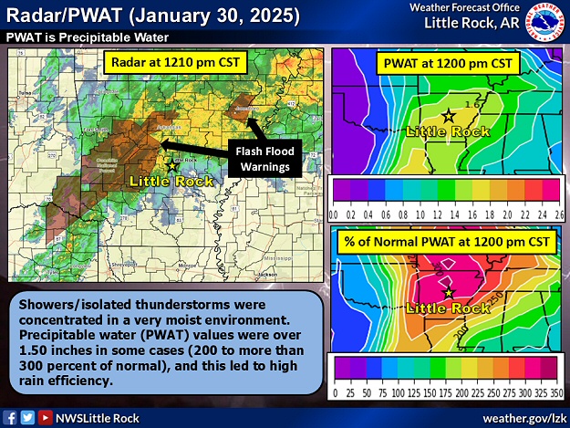
In the picture: The WSR-88D (Doppler Weather Radar) showed showers/isolated thunderstorms concentrated in a very moist environment in Arkansas at 1210 pm CST on 01/30/2025. Precipitable water (PWAT) values were over 1.50 inches in some cases (200 to more than 300 percent of normal), and this led to high rain efficiency.
Moisture levels were two to over three times what is expected in late January, and that often leads to heavy to excessive rain. In this case, downpours were most likely in northern, western, and central Arkansas, and the forecast called for three to four weeks of rain (and possibly more) in just two days.
10:55 AM-Here's the latest on areas in a Flood Watch through Thursday. Some of this morning's weather data indicates that the heaviest rain may occur a bit more south/east. This had led us to add some more counties to the watch area. #arwxpic.twitter.com/9t9rgIV3Wz
In the picture: Flash Flood Watches were posted in northern, western, and central Arkansas through 01/30/2025.
The first batch of showers arrived across region during the afternoon/evening of the 29th. However, this event did not get into full swing until the overnight hours and into the 30th. This is when precipitation rates ramped up, and the potential for flash flooding increased markedly.
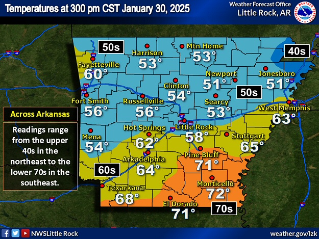
In the picture: Temperatures were only in the 40s/50s in rain cooled air across the northern half of Arkansas at 300 pm CST on 01/30/2025. Farther south, readings climbed into the 60s/70s, and there was an outside chance of severe weather.
Widespread rain/rumbles of thunder held temperatures in the 50s over the northern half of Arkansas during the afternoon of the 30th. By then, Flash Flood Warnings were in place, and high water issues were occurring. There was little to nothing falling from the sky farther south, and this allowed the environment to warm up (readings in the 60s/70s). In this part of the state, there was an outside chance of severe weather (that did not materialize).
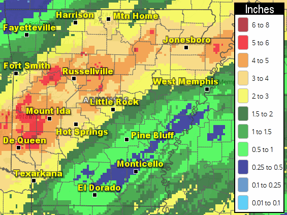
In the picture: Forty eight hour rainfall through 600 am CST on 01/31/2025.
Once the event ended, some places north/west of Little Rock (Pulaski County) received over five inches of rain. Forty eight hour totals ending at 600 am CST on the 31st included 5.99 inches at Cushman (Independence County), 5.71 inches at Langley (Pike County), 5.53 inches at Big Fork (Polk County), 5.32 inches at Mountain View (Stone County), 5.31 inches at Mount Ida (Montgomery County), 5.30 inches at Dierks (Howard County), 5.23 inches at Beedeville (Jackson County), 5.19 inches at Long Pool (Pope County), 5.05 inches at Botkinburg (Van Buren County), 5.04 inches at Subiaco (Logan County), 5.02 inches at Batesville (Independence County), 5.01 inches at Center Ridge (Conway County), and 5.00 inches at Evening Shade (Sharp County).
Too much rain flooded Highway 80 west of Waldron (Scott County), Highway 307 north of Belleville (Yell County), Highway 224 south of Swifton (Jackson County), the intersection of Highways 115 and 117 near Jesup (Lawrence County), and Highway 175 at Cherokee Village (Sharp County). There was a vehicle stalled in high water along a county road southwest of Brookland (Craighead County). Creeks overflowed and there was water in a basement east of Vilonia (Faulkner County).
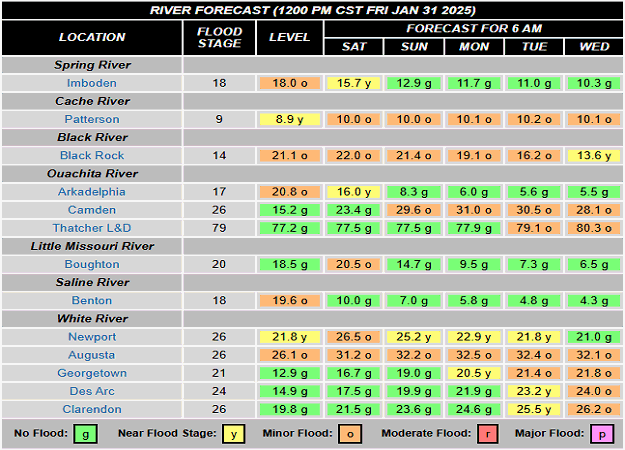
In the picture: Minor river flooding was expected or already occurring along several tributaries in Arkansas on 01/31/2025.
Area tributaries became elevated, with moderate flooding experienced on the Petit Jean River at Danville (Yell County). Otherwise, flooding was generally minor along portions of the Black, Cache, Fourche LaFave, Little Missouri, Ouachita, Saline, Spring, and White Rivers.