 |
| Storm Reports |
| Are you interested in what happened during a recent event? Check out the report below. |
|
|
 |
Spotty Severe Storms Then Cooling Off/Dry on August 19-31, 2023 |
 |
| |
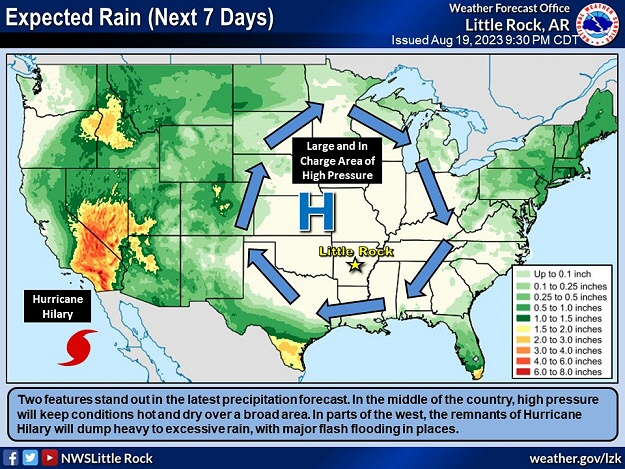 |
| In the picture: High pressure ("H") provided widespread oppressive (hot/humid) conditions in Arkansas by 08/19/2023. There was also little to no rain. Meanwhile, the remnants of Hurricane Hilary dumped heavy to excessive rain in the western United States. |
|
| |
|
Excessive heat and a lack of rain were on the menu heading into the latter half of August. From the 19th through the 26th, triple digits temperatures were common, especially in central and southern Arkansas. During much of this time frame, there wasn't a drop of precipitation statewide.
As the rain stopped locally, the remnants of Hurricane Hilary brought a deluge to the western states (a rare event). A year's worth of liquid was measured at Death Valley National Park (in southern California) on the 20th. The 2.20 inches of rain made it the wettest day on record at the site. State rainfall records due to a tropical system were set in Idaho, Montana, Nevada, and Oregon.
|
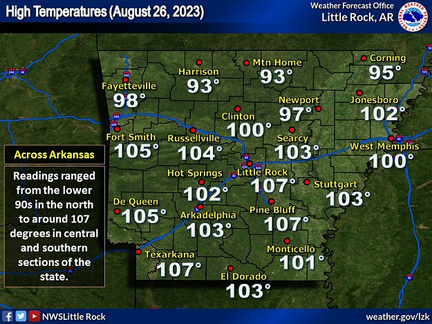 |
| In the picture: High temperatures on 08/26/2023. Readings ranged from the lower 90s in northern Arkansas to around 107 degrees in central and southern sections of the state. |
|
| |
|
Back in Arkansas, perhaps the hottest day of the month was the 26th. The high temperature was 107 degrees at Little Rock (Pulaski County), Pine Bluff (Jefferson County), and Texarkana (Miller County), and 105 degrees at De Queen (Sevier County) and Fort Smith (Sebastian County). Heat index values topped 115 degrees in places.
|
 |
| Forecast Map (08/26) | Forecast Map (08/27) |
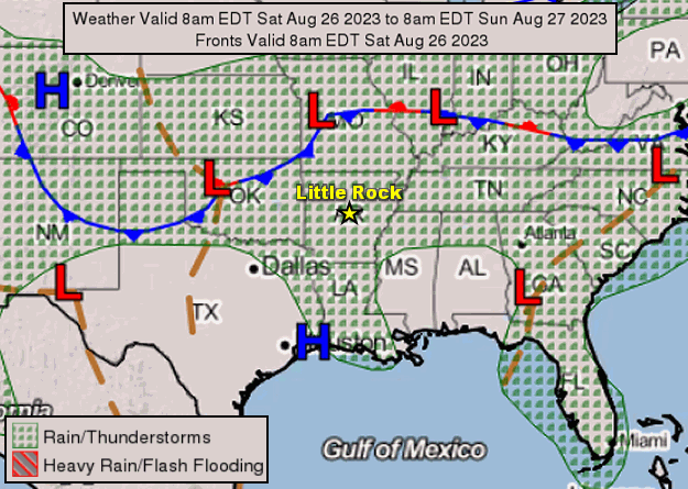
| In the pictures: Forecast maps showed a cold front pushing into Arkansas from the north on 08/26/2023, and exiting the state toward the Gulf Coast the next day. The front triggered scattered strong to severe thunderstorms. |
|
| |
|
Fortunately, the big area of high pressure responsible for the heat high wobbled toward the Rockies, and allowed a cold front to head this way from the north. The front triggered strong to severe thunderstorms.
|
|
|
| In the video: The WSR-88D (Doppler Weather Radar) showed scattered strong to severe thunderstorms in northeast Arkansas at 410 pm CDT on 08/26/2023. Precipitation eventually spread into the central counties. |
|
| |
|
Storms were focused across northeast Arkansas by 400 pm CDT or so. Later in the afternoon and early evening, storms developed farther south toward Little Rock (Pulaski County).
Thunderstorm winds downed trees and power lines in Charlotte, Cord, and Newark (all in Independence County). The temperature dropped from 97 degrees to 73 degrees near Cushman (Independence County). Multiple power poles were snapped southeast of Hartman (Johnson County). A toppled tree blocked Highway 128 just north of Lonsdale (Garland County). There was more tree damage at a cemetery northeast of El Paso (White County).
|
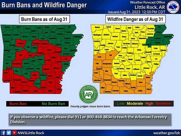 |
| In the picture: As August ended, there was a moderate to high wildfire danger in all but northeast Arkansas. Burn bans were posted in thirty two (of seventy five) counties. |
|
| |
|
After the front passed through (by the 27th), conditions were much more comfortable. Temperatures peaked in the mid 80s to mid 90s, and humidity levels were low. While that was good news for folks working and playing outdoors, it stressed vegetation. By the end of the month, county burn bans markedly increased, and wildfires were a big concern.
To the south, it felt like a furnace along the Gulf Coast on the 27th. All-time record high temperatures were tied at Houston, TX (109 degrees) and broken at New Orleans, LA (105 degrees). At the former location, the same reading was reached on the 24th and on September 4, 2000.
|
 |
| In the picture: The forecast on 08/28/2023 called for Tropical Storm Idalia to become a major hurricane before reaching the Florida Gulf Coast less than forty eight hours later. |
|
| |
|
In the tropics, Hurricane Idalia made landfall near Keating Beach, FL during the morning of the 30th. This was a Category 3 storm (maximum sustained wind around 125 mph). A life threatening storm surge sent water inland and flooded up to 6,000 homes twenty to thirty miles north of Tampa, FL (Pasco County). Record storm surges were observed in spots such as Cedar Key, FL. At least half a million utility customers in Florida lost power.
|
|
|
| In the video: As the circulation (around the eye) of Hurricane Idalia went from offshore to onshore, water rushed into Keating Beach, FL (significant and life threatening storm surge) early on 08/30/2023. The video is courtesy of Brian Emfinger via X (formally Twitter). |
|
| |
|
Idalia remained a hurricane in southern Georgia before weakening to a tropical storm in the Carolinas. Along the path of the system, five to more than ten inches of rain fell. Flooding temporarily closed Highway 75 near Valdosta, GA. At Charleston, SC, a flow inland ahead of Idalia caused water to top a seawall protecting the city. It was the fifth highest water level on record, and this led to major coastal inundation in the downtown area. In nearby Goose Creek, SC, a tornado flipped a car onto another vehicle along U.S. Highway 52. Two people were injured.
|
|
|

