 |
| For Your Information |
| If there is something that may be of interest to you, we will try to make that information available. |
|
|
 |
Remembering Big Events in Recent Junes |
 |
| |
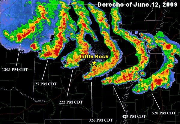 |
| In the picture: A long-lived bow echo, or "derecho" (Spanish for "straight", or in this case, straight-line winds), rocketed eastward across Arkansas in four to five hours during the afternoon of 06/12/2009. |
|
| |
|
On June 12, 2009, a long-lived bow echo, or "derecho", produced 60 to 80 mph winds and locally higher gusts (more than hurricane force) as it raced from northwest into central and east central Arkansas. A bow echo is a backwards "C" shaped line of storms. Strong to damaging winds often punch through the rear of the storms, causing them to bulge forward (which explains the bowing). There were numerous trees and power lines downed, and spotty structural damage. At least 70,000 homes were left without power.
|
 |
On the 30th, big hailstorms mushroomed over central sections of the state. Quarter to baseball size stones tore up roofs, siding, vehicles and crops from North Little Rock and Sherwood (both in Pulaski County) to Lonoke (Lonoke County). Most of the hail in the two county area occurred between 430 pm and 600 pm CDT. |
| In the picture: The WSR-88D (Doppler Weather Radar) showed high reflectivities aloft (at 25,000 feet), indicating a hail core with a storm over Sherwood (Pulaski County) at 509 pm CDT on 06/30/2009. Reflectivity is the amount of energy returning to the radar after sampling a storm. Ice (hail) happens to be a very good reflector. Golfball to baseball size hail occurred with the storm. |
| One car dealer said it was the first time in the 40 year history of the dealership that a "hail sale" would be held. The University of Arkansas Cooperative Extension Service indicated that between 22 and 27 farmers lost 60% to 100% of their crops. Corn stalks that were 8 feet tall were cut in half and soybeans were beaten to the ground. |
 |
| In the picture: Quarter size hail covered the ground at the National Weather Service in North Little Rock (Pulaski County) during the afternoon of 06/30/2009. Click to enlarge. |
 |
A year later (on June 11, 2010), a slow moving storm system aloft wobbled into the state from Texas. During the predawn hours, the system produced over six inches of rain in parts of the Ouachita Mountains, including the Albert Pike Recreation Area (Montgomery County). The Little Missouri River rose twenty feet in just a few hours, and claimed twenty lives. |
| In the picture: Twenty four hour precipitation through 700 am CDT on 06/11/2010. |
|
In late June of 2012, a horrible drought was underway locally following the driest April/May on record. A ridge of high pressure (common summertime feature) built over much of the country. This resulted in record heat.
|
 |
| In the picture: High temperatures on 06/28/2012. |
|
On the 28th, the mercury topped out at 109 degrees at Mountain Home (Baxter County), Russellville (Pope County) and Searcy (White County). All-time record high temperatures for June were set at Harrison (Boone County) and Little Rock (Pulaski County). It was 107 degrees at both places.
Interestingly, it was just about the hottest June afternoon ever a few days earlier (on the 25th), with several monthly heat records snapped. Those records were met or exceeded.
|
 |
| Before Rain | After Rain |
| In the pictures: A field was turned into a lake at McCrory (Woodruff County) on 06/29/2014. The photos are courtesy of LeAnne Gaddy via Twitter. |
|
| |
|
Moving forward a couple of years, the sky opened over eastern Arkansas during the wee hours of June 29th. A system aloft from the northwest triggered a gully washer that resulted in more than a half foot of rain. Rising water led to evacuations of homes, especially in Crittenden, Monroe, St. Francis and Woodruff Counties. Main thoroughfares were blocked by water and closed, including U.S. Highway 49. The Cache River at Patterson (Woodruff County) swelled to over 11 feet (flood stage is 9 feet), and this flooded thousands of acres of farmland. A Flash Flood Emergency was issued by the National Weather Service in and around Memphis, TN.
|
| Federal Disaster Declaration |
|
Federal disaster declarations were made in ten (10) counties mainly due to excessive rain and widespread flooding. This included Cross, Independence, Jackson, Lee, Lonoke, Monroe, Prairie, St. Francis, White and Woodruff Counties.
|
|
In the twenty four hours ending at 700 am CDT on the 29th, Little Dixie (Woodruff County) got a staggering 10.32 inches of precipitation! At Howell (Woodruff County), 9.66 inches fell, with 7.45 inches at McCrory (Woodruff County), 7.10 inches at Georgetown (White County), 6.60 inches at Madison (St. Francis County), 5.34 inches at Oil Trough (Independence County) and 4.75 inches at Des Arc (Prairie County).
A 24-hour rainfall record was snapped at Augusta (Woodruff County), with 7.50 inches edging the previous record of 7.30 inches on November 19, 1988.
|
 |
| In the picture: Record or near record crests occurred along the Arkansas River in late May and early June, 2019. At several forecast points, previous record crests were surpassed by more than two feet. |
|
| |
|
In early June of 2019, the Arkansas River rose to unprecedented levels at several forecast points. Crests were more than two feet above previous high marks at Van Buren (Crawford County), Toad Suck (Perry County), and Pendleton (Desha County).
As the month began, a breached levee near Dardanelle (Yell County) sent torrents of water toward town. Sandbagging took place to protect property from rising water. While many homes were spared, farms and farmland in the area were heavily impacted, and there was major damage to Highway 155.
|
|
|
| In the picture: The Lollie Levee near Conway (Faulkner County) held its ground on 06/07/2019 against a record high Arkansas River. The information is courtesy of the City of Conway via Twitter. |
|
| |
|
There was also a lot happening around Conway (Faulkner County). On the 3rd, a Flood Warning was issued for Lake Conway as Palarm Creek backed up. People were advised to evacuate before water flowed into houses surrounding the lake a couple of days later.
Meanwhile, there were images of Lollie Levee eroding, and it appeared that failure was imminent. This put parts of Conway (Faulkner County) in danger of flooding. There were more evacuations, and the situation was monitored closely. By the 7th, it became clear that the levee would hold. The levee was presented a key to the city on the 10th.
|
|
|


