|
| Storm Reports |
| Are you interested in what happened during a recent event? Check out the report below. |
|
|
 |
Beryl Brings Tornadoes/Flooding Rain on July 8-9, 2024 |
 |
| |
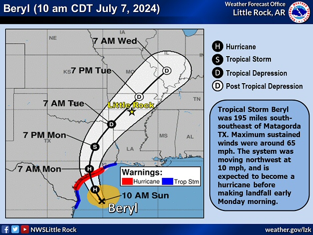 |
| In the picture: Tropical Storm Beryl was closing in on the Texas Gulf Coast on 07/07/2024. The system became a hurricane before making landfall early the next morning. Soon after, the remnants of Beryl made an appearance in Arkansas, and unleashed areas of heavy rain/isolated tornadoes. |
|
| |
|
June was a dry month across much of northern and parts of central Arkansas. One to more than three inch rainfall deficits were common. As July began, drought conditions existed in some areas north of Little Rock (Pulaski County). Downpours were needed, and they eventually came from the tropics.
Before dawn on July 8th, Hurricane Beryl made landfall near Matagorda, TX with 80 mph sustained winds. As Beryl moved inland and gradually weakened, the outer bands of the system headed in our direction.
|
| More About Beryl |
|
At one time, Beryl was a Category 5 hurricane (top of the scale/maximum sustained winds close to 165 mph) in the eastern Caribbean Sea late on July 1st/early on the 2nd. Beryl maintained Category 4 status (140 mph sustained winds) as the system brushed the southern coast of Jamaica on the 3rd. Two days later, Beryl hit the Yucatan Peninsula as a Category 2 hurricane (110 mph winds) before weakening into a Tropical Storm and eventually emerging into the Gulf of America.
|
 |
| Tornadic Storm in Dallas County | Tornado Warnings Nationwide (July 7-10) |
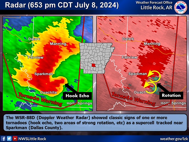
| In the pictures: The WSR-88D (Doppler Weather Radar) showed classic signs of one or more tornadoes (hook echo, two areas of strong rotation, etc) as a supercell tracked near Sparkman (Dallas County) during the early evening of 07/08/2024. A Tornado Warning was in effect at the time. This was one of more than two hundred Tornado Warnings issued from the Texas Gulf Coast to New England on July 7-10, 2024. |
|
| |
|
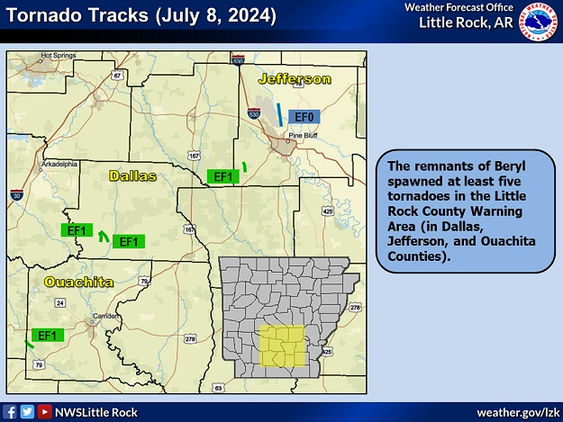
During the afternoon and evening, scattered thunderstorms across the central and southern counties exhibited strong rotation at times. Tornado Warnings were issued in places, and nine tornadoes were spawned.
|
| Beryl Making History |
|
There were ten tornadoes tallied in Arkansas on July 8th (associated with the remnants of Beryl). This was the largest July tornado outbreak in the state (previous record was five tornadoes on the 9th in 1964), and the most tornadoes in the month of July (topping the eight tornadoes in 2009).
|
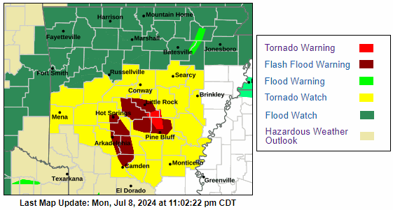 |
| In the picture: Headlines for tornadoes and flash flooding were posted in Arkansas during the evening of 07/08/2024 as the remnants of Hurricane Beryl approached from Texas. |
|
| |
|
If that wasn't enough, areas of heavy rain followed. Tropical moisture led to a deluge, with rainfall rates topping five inches per hour!
|
|
|
| |
|
As far as the tornadoes, there were five of them tallied in the Little Rock County Warning Area. They were generally brief and weak (rated EF0/EF1), and affected Dallas, Jefferson, and Ouachita Counties (with the latter tornado nudging into eastern Nevada County before dissipating). Mostly tree damage was observed, but there was also spotty minor structural damage. In the southwest, five additional weak tornadoes skipped through Columbia, Lafayette, and Miller Counties.
|
|
|
| In the video: The WSR-88D (Doppler Weather Radar) showed very heavy rain spreading into Faulkner and White Counties from Pulaski, Lonoke, and Prairie Counties (all in central Arkansas) at 1220 am CDT on 07/09/2024. |
|
| |
|
Once the clouds opened, it was impressive. Roughly six tenths of an inch of rain dumped at the North Little Rock Airport (Pulaski County) in five minutes (a rate of 7.20 inches an hour).
|
|
|
| |
|
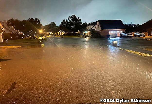
Precipitation came down much faster than it could be carried away, and there was street flooding in the Little Rock (Pulaski County) area and at Bryant (Saline County). Roads were also under water at Hickory Plains (Prairie County). If not for the drought and a dry June, high water problems would have likely been more widespread.
|
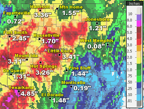 |
| In the picture: Twenty four hour rainfall through 700 am CDT on 07/09/2024. |
|
| |
|
In the twenty four hour period ending at 700 am CDT on the 9th, multiple locations got more than five inches of rain. Morrilton (Conway County) had 6.54 inches (the second highest one day total since records began in 1919), with 6.03 inches at Millwood Dam (Little River County), 5.90 inches at Center Ridge (Conway County), 5.30 inches at Crystal Valley (Pulaski County), and 5.09 inches at Mountain View (Stone County). Interestingly, parts of southeast Arkansas received amounts less than a quarter inch.
|
| Twenty Four Hour Rainfall Through 700 am CDT on 07/09/2024 |
| Site |
Amount (Inches) |
| Morrilton (Conway Co) |
6.54 |
| Millwood Dam (Little River Co) |
6.03 |
| Center Ridge (Conway Co) |
5.90 |
| Crystal Valley (Pulaski Co) |
5.30 |
| Mountain View (Stone Co) |
5.09 |
| DeGray Lake SP (Clark/Hot Spring Cos) |
4.97 |
| Perry (Perry Co) |
4.95 |
| Texarkana (Miller Co) |
4.85 |
| Batesville (Independence Co) |
4.80 |
| Antoine (Pike Co) |
4.76 |
| Nashville (Howard Co) |
4.68 |
| Heber Springs (Cleburne Co) |
4.57 |
| Benton (Saline Co) |
4.53 |
| Greers Ferry Dam (Cleburne Co) |
4.35 |
| Newport (Jackson Co) |
4.20 |
| Booneville (Logan Co) |
4.10 |
| Ozone (Johnson Co) |
4.10 |
| Jasper (Newton Co) |
4.00 |
|
Checking the CoCoRaHs (Community Collaborative Rain, Hail, and Snow) network, a gauge about five miles south of Texarkana (Miller County) collected 7.27 inches of liquid, with 6.85 inches three miles west of Greenbrier (Faulkner County), 6.84 inches two to three miles west of Conway (Faulkner County), and 6.70 inches two miles northeast of Bigelow (Perry County).
On the 9th (after 700 am CDT), showers and a few rumbles of thunder lingered before the remnants of Beryl exited to the northeast. An inch or more of water was measured at a few locales, including Mountain Home (Baxter County) with 1.51 inches.
|
|
|